<?xml version="1.0" encoding="ISO-8859-1"?><article xmlns:mml="http://www.w3.org/1998/Math/MathML" xmlns:xlink="http://www.w3.org/1999/xlink" xmlns:xsi="http://www.w3.org/2001/XMLSchema-instance">
<front>
<journal-meta>
<journal-id>0012-7353</journal-id>
<journal-title><![CDATA[DYNA]]></journal-title>
<abbrev-journal-title><![CDATA[Dyna rev.fac.nac.minas]]></abbrev-journal-title>
<issn>0012-7353</issn>
<publisher>
<publisher-name><![CDATA[Universidad Nacional de Colombia]]></publisher-name>
</publisher>
</journal-meta>
<article-meta>
<article-id>S0012-73532016000500006</article-id>
<article-id pub-id-type="doi">10.15446/dyna.v83n199.55589</article-id>
<title-group>
<article-title xml:lang="en"><![CDATA[Reduction of computational times using the equivalent rectangle concept in the physics-based surface: subsurface models]]></article-title>
<article-title xml:lang="es"><![CDATA[Reducción de tiempos computacionales usando el concepto de rectángulo equivalente en los modelos físicos superficiales: subsuperficiales]]></article-title>
</title-group>
<contrib-group>
<contrib contrib-type="author">
<name>
<surname><![CDATA[Hurtado]]></surname>
<given-names><![CDATA[Juliana]]></given-names>
</name>
<xref ref-type="aff" rid="A01"/>
</contrib>
<contrib contrib-type="author">
<name>
<surname><![CDATA[Causapé]]></surname>
<given-names><![CDATA[Jesús]]></given-names>
</name>
<xref ref-type="aff" rid="A02"/>
</contrib>
<contrib contrib-type="author">
<name>
<surname><![CDATA[Abrahao]]></surname>
<given-names><![CDATA[Raphael]]></given-names>
</name>
<xref ref-type="aff" rid="A03"/>
</contrib>
<contrib contrib-type="author">
<name>
<surname><![CDATA[Pérez]]></surname>
<given-names><![CDATA[Anibal J.]]></given-names>
</name>
<xref ref-type="aff" rid="A04"/>
</contrib>
</contrib-group>
<aff id="A01">
<institution><![CDATA[,Universidad Antonio Nariño Facultad de Ingeniería Ambiental ]]></institution>
<addr-line><![CDATA[Bogotá ]]></addr-line>
<country>Colombia</country>
</aff>
<aff id="A02">
<institution><![CDATA[,Instituto Geológico y Minero de España  ]]></institution>
<addr-line><![CDATA[Zaragoza ]]></addr-line>
<country>España</country>
</aff>
<aff id="A03">
<institution><![CDATA[,Universida de Federal da Paraiba Facultad de Energía Renovable ]]></institution>
<addr-line><![CDATA[Paraiba ]]></addr-line>
<country>Brasil</country>
</aff>
<aff id="A04">
<institution><![CDATA[,Universidad Antonio Nariño Facultad de Ingeniería Ambiental ]]></institution>
<addr-line><![CDATA[Bogotá ]]></addr-line>
<country>Colombia</country>
</aff>
<pub-date pub-type="pub">
<day>00</day>
<month>12</month>
<year>2016</year>
</pub-date>
<pub-date pub-type="epub">
<day>00</day>
<month>12</month>
<year>2016</year>
</pub-date>
<volume>83</volume>
<numero>199</numero>
<fpage>50</fpage>
<lpage>56</lpage>
<copyright-statement/>
<copyright-year/>
<self-uri xlink:href="http://www.scielo.org.co/scielo.php?script=sci_arttext&amp;pid=S0012-73532016000500006&amp;lng=en&amp;nrm=iso"></self-uri><self-uri xlink:href="http://www.scielo.org.co/scielo.php?script=sci_abstract&amp;pid=S0012-73532016000500006&amp;lng=en&amp;nrm=iso"></self-uri><self-uri xlink:href="http://www.scielo.org.co/scielo.php?script=sci_pdf&amp;pid=S0012-73532016000500006&amp;lng=en&amp;nrm=iso"></self-uri><abstract abstract-type="short" xml:lang="en"><p><![CDATA[The interaction between surface and subsurface domains in a basin can be studied using a physics-based model; however, the calibration and validation processes require a high computational effort due to their complex geometry. The authors propose an alternative to reduce the computational times during the calibration model by simplifying the geometry of the watershed that applies the equivalent rectangle concept. A quasi-3D equivalent rectangle is used to define the specific soil parameters of the Lerma river basin through sensitivity analysis that will later be applied in the calibration. The simplified model can highly accurately identify the parameter range for the initial values of the calibration process as well as if the reduction in running times is significant. Thus, the rectangle equivalent concept offers an alternative to speed-up the calibration of a 3-D fully-coupled surface sub-surface model.]]></p></abstract>
<abstract abstract-type="short" xml:lang="es"><p><![CDATA[La interacción entre la superficie y subsuperficie de una cuenca se puede estudiar utilizando modelos físicos, pero debido a su compleja geometría los procesos de calibración y validación requieren altos tiempos computacionales. Para ello, se propone una alternativa que permita reducir los tiempos de calibración del modelo, mediante la simplificación de la geometría de la cuenca y empleando el concepto del rectángulo equivalente. El rectángulo equivalente es usado para definir los parámetros del suelo de la cuenca del río Lerma, a través de un análisis de sensibilidad, que posteriormente son empleados dentro de la calibración. El modelo simplificado identifica con una gran precisión los rangos y valores iniciales de los parámetros utilizados para los procesos de calibración y además reduce significativamente los tiempos computacionales. Por lo tanto, el concepto de rectángulo equivalente ofrece una alternativa para acelerar la calibración de modelos acoplados superficie-subsuperficie.]]></p></abstract>
<kwd-group>
<kwd lng="en"><![CDATA[Equivalent rectangle]]></kwd>
<kwd lng="en"><![CDATA[calibration]]></kwd>
<kwd lng="en"><![CDATA[parameterization]]></kwd>
<kwd lng="en"><![CDATA[surface-subsurface model]]></kwd>
<kwd lng="en"><![CDATA[hydrological modeling]]></kwd>
<kwd lng="es"><![CDATA[Rectángulo equivalente]]></kwd>
<kwd lng="es"><![CDATA[calibración]]></kwd>
<kwd lng="es"><![CDATA[parametrización]]></kwd>
<kwd lng="es"><![CDATA[modelos superficial-subsuperficial]]></kwd>
<kwd lng="es"><![CDATA[modelación hidrológica]]></kwd>
</kwd-group>
</article-meta>
</front><body><![CDATA[ <p><font size="1" face="Verdana, Arial, Helvetica, sans-serif"><b>DOI:</b> <a href="http://dx.doi.org/10.15446/dyna.v83n199.55589" target="_blank">http://dx.doi.org/10.15446/dyna.v83n199.55589</a></font></p>    <p align="center"><font size="4" face="Verdana, Arial, Helvetica, sans-serif"><b>Reduction of computational times using the  equivalent rectangle concept in the physics-based surface - subsurface models</b></font></p>     <p align="center"><i><b><font size="3" face="Verdana, Arial, Helvetica, sans-serif">Reducci&oacute;n de  tiempos computacionales usando el concepto de rect&aacute;ngulo equivalente en los modelos f&iacute;sicos superficiales - subsuperficiales</font></b></i></p>     <p align="center">&nbsp;</p>     <p align="center"><b><font size="2" face="Verdana, Arial, Helvetica, sans-serif">Juliana Hurtado <i><sup>a</sup></i>,   Jes&uacute;s Causap&eacute; <i><sup>b</sup></i>, Raphael Abrahao <i><sup>c</sup></i> &amp; Anibal J. P&eacute;rez <i><sup>d</sup></i></font></b></p>     <p align="center">&nbsp;</p>     <p align="center"><font size="2" face="Verdana, Arial, Helvetica, sans-serif"><sup><i>a</i></sup><i> Facultad de Ingenier&iacute;a Ambiental, Universidad Antonio Nari&ntilde;o, Bogot&aacute;, Colombia.       <a href="mailto:julihurtadop@gmail.com">julihurtadop@gmail.com</a>    <br>   <sup>b </sup>Instituto   Geol&oacute;gico y Minero de Espa&ntilde;a (IGME), Zaragoza, Espa&ntilde;a. <a href="mailto:j.causape@igme.es">j.causape@igme.es</a>    <br>     <sup>c</sup> Facultad de Energ&iacute;a Renovable, Universidade       Federal da Paraiba, Paraiba, Brasil.       <a href="mailto:raphael@cear.ufpb.br">raphael@cear.ufpb.br</a>    <br>       <sup>d</sup> Facultad de Ingenier&iacute;a Ambiental, Universidad Antonio Nari&ntilde;o, Bogot&aacute;,         Colombia. <a href="mailto:anibperez@uan.edu.co">anibperez@uan.edu.co</a></i></font></p>     ]]></body>
<body><![CDATA[<p align="center">&nbsp;</p>     <p align="center"><font size="2" face="Verdana, Arial, Helvetica, sans-serif"><b>Received:   February 3<sup>rd</sup>, de 2016. Received in revised form: July 5<sup>th</sup>,   2016. Accepted: August 26<sup>th</sup>, 2016</b></font></p>     <p align="center">&nbsp;</p>     <p align="center"><font size="1" face="Verdana, Arial, Helvetica, sans-seriff"><b>This work is licensed under a</b> <a rel="license" href="http://creativecommons.org/licenses/by-nc-nd/4.0/">Creative Commons Attribution-NonCommercial-NoDerivatives 4.0 International License</a>.</font><br /><a rel="license" href="http://creativecommons.org/licenses/by-nc-nd/4.0/"><img style="border-width:0" src="https://i.creativecommons.org/l/by-nc-nd/4.0/88x31.png" /></a></p><hr> <font size="2" face="Verdana, Arial, Helvetica, sans-serif"><b>Abstract</b></font><font size="2" face="Verdana, Arial, Helvetica, sans-serif">    <br> The  interaction between surface and subsurface domains in a basin can be studied  using a physics-based model; however, the calibration and validation processes  require a high computational effort due to their complex geometry. The authors  propose an alternative to reduce the computational times during the calibration  model by simplifying the geometry of the watershed that applies the equivalent  rectangle concept. A quasi-3D equivalent rectangle is used to define the  specific soil parameters of the Lerma river basin through sensitivity analysis  that will later be applied in the calibration. The  simplified model can highly accurately identify the parameter range for the  initial values of the calibration process as well as if the reduction in  running times is significant. Thus, the rectangle equivalent concept offers an  alternative to speed-up the calibration of a 3-D fully-coupled surface  sub-surface model.</font>     <p></p>     <p><font size="2" face="Verdana, Arial, Helvetica, sans-serif"><i>Keywords:</i> Equivalent  rectangle; calibration; parameterization; surface-subsurface model;  hydrological modeling. </font></p>     <p><font size="2" face="Verdana, Arial, Helvetica, sans-serif"><b>Resumen    <br> </b></font><font size="2" face="Verdana, Arial, Helvetica, sans-serif">La interacci&oacute;n  entre la superficie y subsuperficie de una cuenca se puede estudiar utilizando  modelos f&iacute;sicos, pero debido a su compleja geometr&iacute;a los procesos de  calibraci&oacute;n y validaci&oacute;n requieren altos tiempos computacionales. Para ello, se  propone una alternativa que permita reducir los tiempos de calibraci&oacute;n del  modelo, mediante la simplificaci&oacute;n de la geometr&iacute;a de la cuenca y empleando el  concepto del rect&aacute;ngulo equivalente. El rect&aacute;ngulo equivalente es usado para  definir los par&aacute;metros del suelo de la cuenca del r&iacute;o Lerma, a trav&eacute;s de un  an&aacute;lisis de sensibilidad, que posteriormente son empleados dentro de la  calibraci&oacute;n. El modelo simplificado identifica con una gran precisi&oacute;n los  rangos y valores iniciales de los par&aacute;metros utilizados para los procesos de  calibraci&oacute;n y adem&aacute;s reduce significativamente los tiempos computacionales. Por  lo tanto, el concepto de rect&aacute;ngulo equivalente ofrece una alternativa para acelerar la calibraci&oacute;n de modelos acoplados superficie-subsuperficie.</font></p>     <p><font size="2" face="Verdana, Arial, Helvetica, sans-serif"><i>Palabras Clave:</i> Rect&aacute;ngulo equivalente; calibraci&oacute;n;  parametrizaci&oacute;n; modelos superficial-subsuperficial; modelaci&oacute;n hidrol&oacute;gica.</font></p> <hr>     ]]></body>
<body><![CDATA[<p>&nbsp;</p>     <p><font size="3" face="Verdana, Arial, Helvetica, sans-serif"><b>1. Introduction</b></font></p>     <p><font size="2" face="Verdana, Arial, Helvetica, sans-serif">Modeling  is a basic tool in hydrology since it enables predictions and diagnoses of the  basin flows and it generally takes into account the study area's environmental  characteristics. Models can be physical, analogue, or mathematical. Physical  models have been very important in the past. However, the mathematical group of  models is the most easily and universally applied and the one with the most  rapid development regarding having a scientific basis and application &#91;1&#93;. According to the applicability and the objective of the simulation,  there are different types of models that can be used (lumped, distributed,  conceptual, physics-based, among others) and these accurately represent the  analyzed natural system. Among these models, the fully-coupled physics-based  models have arisen as useful tools to represent hydrological processes of a  catchment area &#91;2-9&#93;. The study focused on the  interaction between surface and subsurface flow in a basin using the  physics-based hydrological models &#91;10-12&#93;. These describe water movement by  solving the diffusive wave approximation of the shallow water equations in the  overland flow, and are helped by Richard's equation. However, for the  calibration and validation processes, these models need longer computational  times due to the high temporal and spatial resolution required. </font></p>     <p><font size="2" face="Verdana, Arial, Helvetica, sans-serif">Considering  the spatial accuracy needed in the model, the whole catchment area and its  boundaries are discretized by several thousand grid nodes. Each node has  specific values for the parameters used in the model. To reduce the number of  calibration parameters, zones of homogeneous parameter values have been set;  this is in order to evaluate and identify which parameters are available from  field data and which ones need some fitting. An additional condition for the  calibration parameter selection is that parameters must influence the model  output, i.e. model predictions should be sensitive to changes in the values of  the parameters: this feature is called identifiability.</font></p>     <p><font size="2" face="Verdana, Arial, Helvetica, sans-serif">In  these types of models, parameters' values are estimated with a manual  trial-and-error procedure since the automated calibration codes -which use  mathematical optimization algorithms-, have difficulties with sparse data or  require too many model runs &#91;13&#93;. Therefore, the modeler's  experience is very important for the success and quality of the results.</font></p>     <p><font size="2" face="Verdana, Arial, Helvetica, sans-serif">Sensitivity  studies are a suitable tool to quantify the influence of the initial set of  parameters' values on the model outputs. Commonly, the methods use direct  numerical differentiation, and the simulation repeats with a slightly different  parameters value. There are two different kinds of sensitivity analysis, the  first, local sensitivities, evaluates the sensitivity at one point of the  parameter space and is usually applied in simple hydrological modeling cases.  The second, global analysis, repeats the first method at many points of the  parameter space. These processes require the previously mentioned huge  computational effort; however, the physics-based models demand a high temporal  and spatial resolution. Thus, a method to solve these problems is proposed  using a geometrical simplifications model, where the topography and geology  become simpler. </font></p>     <p><font size="2" face="Verdana, Arial, Helvetica, sans-serif">A  quasi-3D equivalent rectangle model (ERM), similar to that presented in &#91;14&#93; is suggested as a substitute for  the 3-D fully-coupled model, and it has the purpose of speeding up the  parameterization and calibration processes. In this method, certain geometrical  characteristics such as surface area and perimeter remain the same as in the  original model, while other parameters are simplified, such as the elevation  distribution of the watershed, which is represented by the hypsometric curve.  The ERM may be applied to small to moderate catchments, in which the slope has  an important feature in the basin and can be represented without taking into account  lateral variation in the geology.</font></p>     <p><font size="2" face="Verdana, Arial, Helvetica, sans-serif">The aim  of the study is to show that the simplified proposed approximation can assess  and identify the suitable parameter ranges and the respective sensitivity. It  will then transfer it to a realistic model (3-D physic-based model), which will  reduce computational times. The study focuses on the Lerma basin, which is  located in the southeast of the Arba watershed in Spain.</font></p>     <p>&nbsp;</p>     <p><font size="3" face="Verdana, Arial, Helvetica, sans-serif"><b>2. Materials and methods</b></font></p>     ]]></body>
<body><![CDATA[<p><font size="2" face="Verdana, Arial, Helvetica, sans-serif">The first step  before performing the calibration is to define the parameters that will be used  in this process. This activity is referred to in the literature as  parameterization &#91;1&#93;, which involves a sensitivity analysis.  Since calibration is typically manual is important to define relatively small  parameter ranges that help to reduce the demanding computational times. Also,  for the sensitivity study, it is adequate to identify the starting parameters'  values (initial guess) as these help to reduce the number of iterations that  are required.</font></p>     <p><font size="2" face="Verdana, Arial, Helvetica, sans-serif">Sensitivity is an important analytical tool  for parameterization as it evaluates and quantifies the influence of the  parameters in the model outputs. If the outputs are sensitive to the change of  parameter values, the parameter is set as identifiable, which is a significant  characteristic for parameterization. For most models, including the  physics-based one, the sensitivities are calculated through numerical  differentiation, which define the model output at a location (<i>x</i>) and a time (<i>t</i>), given a vector of parameters values <b><i>p</i></b> with a total of  parameter values (<img src="/img/revistas/dyna/v83n199/v83n199a06eq002.gif">), defined as <img src="/img/revistas/dyna/v83n199/v83n199a06eq004.gif">. In this case, <img src="/img/revistas/dyna/v83n199/v83n199a06eq006.gif"> can be a simulated hydraulic head of the  subsurface domain or a simulated discharge in the surface domain. To determine  sensitivities, only the model outputs at a location and time where previous  data is recorded or observations have been previously made are considered. A  numerical approximation of the sensitivity <img src="/img/revistas/dyna/v83n199/v83n199a06eq008.gif"> using a forward-difference scheme can computed  as:</font></p>     <p><img src="/img/revistas/dyna/v83n199/v83n199a06eq01.gif"></p>     <p><font size="2" face="Verdana, Arial, Helvetica, sans-serif">Where <img src="/img/revistas/dyna/v83n199/v83n199a06eq014.gif"> is the standard basis vector  at position <i>i,</i> and <img src="/img/revistas/dyna/v83n199/v83n199a06eq016.gif"> is the change (increase) that is applied to each of the analyzed parameters respective to a  defined variable (henceforth perturbation). </font></p>     <p><font size="2" face="Verdana, Arial, Helvetica, sans-serif">If <img src="/img/revistas/dyna/v83n199/v83n199a06eq018.gif"> depends linearly on <b><i>p</i></b>,  more specifically, when small perturbations generate the same effect on the model output no matter the  original parameter value, <img src="/img/revistas/dyna/v83n199/v83n199a06eq020.gif"> simulations will be needed for the  computational process. One will be used for the parameter vector <b><i>p</i></b> and the other for the <img src="/img/revistas/dyna/v83n199/v83n199a06eq022.gif"> for each parameter perturbation (small  increment). Moreover, if the dependence of <img src="/img/revistas/dyna/v83n199/v83n199a06eq018.gif"> on <b><i>p</i></b> is nonlinear, the local  sensitivities can vary significantly since each parameter perturbation depends  not only on the perturbed value, but also on the parameters' values that are  unperturbed. In this case, global sensitivity evaluation is used, for which the  local sensitivities (<img src="/img/revistas/dyna/v83n199/v83n199a06eq024.gif">) are calculated for different  values of each parameter studied <img src="/img/revistas/dyna/v83n199/v83n199a06eq026.gif">. This increases the number of  required simulations. </font></p>     <p><font size="2" face="Verdana, Arial, Helvetica, sans-serif">In our  surface-subsurface model, nonlinearity is present in both governing equations,  the diffusive wave, and the Richards equation. If within the parameterization,  global sensitivities at different parameter values are similar, nonlinearity is  not a problem. However, if sensitivity of one or more parameters changes  drastically, there can be many inconsistences. It should also be pointed out  that a parameter in local sensitivity could be considered unimportant in terms  of hydrological response, but it may be very important in global evaluation. Thus,  for the present study and for the physics-based model, the global sensitivities  analysis is used for each parameter.</font></p>     <p><font size="2" face="Verdana, Arial, Helvetica, sans-serif">As previously stated, global sensitivity can  also be affected by the values chosen for the remaining parameters (i.e.,  unperturbed parameters) &#91;15&#93;; therefore, the global evaluation  should be repeated for several different values in parameter space for the <img src="/img/revistas/dyna/v83n199/v83n199a06eq028.gif"> remaining parameters. These will also increase  the required simulations up to <img src="/img/revistas/dyna/v83n199/v83n199a06eq030.gif">. For this analysis, the  computational effort is high due to the large number of simulations that are  required in order to calculate an absolute global sensitivity (i.e., the total  of the global sensitivity measures) in a physics-based model. </font></p>     <p><font size="2" face="Verdana, Arial, Helvetica, sans-serif">In order to estimate the global sensitivity,  the Composite Scaled Sensitivities (CSS) is applied. CSS evaluates the local  sensitivities for a range of parameters' values; it then groups the data,  classifies each of the parameter analyzed, and finally averages the values  based on the results. CSS was introduced by Hill &#91;16&#93; and can be expressed as &#91;17&#93;:</font></p>     <p><img src="/img/revistas/dyna/v83n199/v83n199a06eq02.gif"></p>     <p><font size="2" face="Verdana, Arial, Helvetica, sans-serif">Where <img src="/img/revistas/dyna/v83n199/v83n199a06eq034.gif"> is the total number of  observations considered to calculate the composited scaled sensitivities, <img src="/img/revistas/dyna/v83n199/v83n199a06eq036.gif"> is a diagonal matrix <img src="/img/revistas/dyna/v83n199/v83n199a06eq038.gif"> of the parameter values used  to calculated the sensitivity, <img src="/img/revistas/dyna/v83n199/v83n199a06eq040.gif"> is the local sensitivity  matrix <img src="/img/revistas/dyna/v83n199/v83n199a06eq042.gif"> containing all terms of the  form <img src="/img/revistas/dyna/v83n199/v83n199a06eq008.gif">, and <img src="/img/revistas/dyna/v83n199/v83n199a06eq044.gif"> is a weighting matrix <img src="/img/revistas/dyna/v83n199/v83n199a06eq046.gif">. For the purposes of comparison, in order to evaluate the  applicability of the simplified model proposed, CSS are computed for both the  simplified model and the real catchment.</font></p>     ]]></body>


<body><![CDATA[<p><font size="2" face="Verdana, Arial, Helvetica, sans-serif">In  conclusion, the parameterization process in the physics-based  surface-subsurface model includes a global sensitivity analysis. This helps to  identify the parameters that are important in model fitting and at what ranges  of values these parameters are sensitive. This would help to define the correct  parameter values for the calibration.</font></p>     <p><font size="2" face="Verdana, Arial, Helvetica, sans-serif">After  the relevant parameters are defined, calibration is performed. The purpose of  the calibration is to establish that the model can reproduce field measurements  and estimate parameter values based on measured quantities. Calibration can be  performed manually or automatically. While manual calibration is deemed to be  subjective due to the arbitrary decision of the modeler about the performance  of the model, automatic calibration may imply significant computation times  that are not affordable in very complex applications. The choice of the  calibration method depends on the modeler and is conditioned by the model  running time. </font></p>     <p><font size="2" face="Verdana, Arial, Helvetica, sans-serif">In order to test whether the calibrated model  performs well, in the sense that the deviations between the measured and  simulated values are within an acceptable range, an <i><font face="Symbol">C</font><sup>2</sup></i>-test of the objective function normalized by the  covariance matrix of the error, C<sub>yy</sub>, is often calculated. In  particular, the optimization function <img src="/img/revistas/dyna/v83n199/v83n199a06eq048.gif"> is used, where<i> DoF </i>is the model's  degree of freedom, which is defined as the difference between the number of  observations and the number of calibration parameters &#91;11&#93;.</font></p>     <p><font size="2" face="Verdana, Arial, Helvetica, sans-serif"><b><i>2.1. A quasi-3D equivalent rectangle model (ERM)</i></b></font></p>     <p><font size="2" face="Verdana, Arial, Helvetica, sans-serif">In order to reduce the computational  times in the parameterization, the geometrical characteristics of the catchment  were simplified by using the equivalent rectangle. What this method does is  convert the watershed 3-D fully coupled model into a quasi-3-D equivalent  rectangle. The model total surface area <i>A</i> and the perimeter <img src="/img/revistas/dyna/v83n199/v83n199a06eq050.gif"> are preserved; these  variables are useful to be able to determine the width (<i>w</i>) and length (<i>l</i>) of the  ERM base plane. The solution for <i>w</i> and <i>l</i> are the following systems:</font></p>     <p><img src="/img/revistas/dyna/v83n199/v83n199a06eq0304.gif"></p>     <p><font size="2" face="Verdana, Arial, Helvetica, sans-serif">The previous equations follow the equivalent  rectangle concept, which was introduced by Roche &#91;18&#93;. They study the influence of the  geometrical characteristics of a basin on its hydrological response. However,  the topographic structure is simplified into a single hillslope, which keeps  the hypsometric curve of the natural basin &#91;14&#93;. The hypsometric curve is an  empirical cumulative distribution function, <img src="/img/revistas/dyna/v83n199/v83n199a06eq058.gif">, that is discretized by a digital  elevation model (DEM). Since the resolution (cell size) of the DEM is known,  the elevation value is associated with frequency <img src="/img/revistas/dyna/v83n199/v83n199a06eq060.gif">, where <img src="/img/revistas/dyna/v83n199/v83n199a06eq062.gif"> is the area of one DEM cell, and <img src="/img/revistas/dyna/v83n199/v83n199a06eq064.gif"> is the total area of the watershed that is  plotted against the elevation values <img src="/img/revistas/dyna/v83n199/v83n199a06eq066.gif">. The cumulative frequency <img src="/img/revistas/dyna/v83n199/v83n199a06eq068.gif"> is plotted along the abscissa and the  elevation along the ordinate. This can  expressed as:</font></p>     <p><img src="/img/revistas/dyna/v83n199/v83n199a06eq05.gif"></p>     <p><font size="2" face="Verdana, Arial, Helvetica, sans-serif">Where <img src="/img/revistas/dyna/v83n199/v83n199a06eq072.gif">, is the  DEM's number of cells and <img src="/img/revistas/dyna/v83n199/v83n199a06eq074.gif"> is an indicator of a random variable, which is  set to 1 when the property <img src="/img/revistas/dyna/v83n199/v83n199a06eq076.gif"> is accomplished. Otherwise the value is zero.</font></p>     <p><font size="2" face="Verdana, Arial, Helvetica, sans-serif">Since the rectangle is uniform in the <i>y</i>-direction, <i>w</i> is set to be uniform and a quasi-3D model is assumed. For the  subsurface domain, given the DEM, the ERM can be reproduced by representing the  hypsometric curve of the aquifer top and bottom surface. Thus, it assumes that  vertical geometry is simple where the catchment boundaries of the surface  coincide with the boundaries of the subsurface. In order to test the ERM in the  parameterization process of the physic-based surface-subsurface model we used  the Lerma catchment.</font></p>     ]]></body>
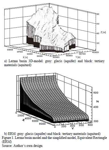
<body><![CDATA[<p>&nbsp;</p>     <p><font size="3" face="Verdana, Arial, Helvetica, sans-serif"><b>3. Case study: Lerma basin</b></font></p>     <p><font size="2" face="Verdana, Arial, Helvetica, sans-serif">The  Lerma basin has an area of approximately 7.5 km<sup>2</sup> and is located  south-east of the Arba catchment, which is within the Ebro basin &#91;2,9&#93;. The catchment is a semi-arid  area that was formerly fallows land that was transformed into an irrigation  agriculture catchment in 2006. It has two lithological units that are characterized by a quaternary  deposit, and the overlying tertiary bedrock is made of lutites and marlstones &#91;9&#93;. The upper unit represents a phreatic aquifer,  hereafter called &quot;glacis&quot;, that is seasonally fed by precipitation and  irrigation (agriculture is a strong activity at the basin). The glacis has  permeable characteristics, it is unconsolidated, and has clastic deposits that  generally are present in arid or semi-arid climates. The tertiary unit  represents an aquitard, hereafter called &quot;buro&quot;. This formation is relatively  sensitive to weathering and fracturing processes, and there is possible  filtration of water from upper layers &#91;9&#93;. Despite being an aquitard, the  model includes the top part of this formation for the simulation.</font></p>     <p><font size="2" face="Verdana, Arial, Helvetica, sans-serif">A  digital elevation model (DEM) of 25 m cell-sized was used. Hydrological  information (daily rainfall, air temperature, wind velocity, relative humidity  and solar radiation) was obtained from a climatological station located five  kilometers from the Lerma basin. A soil characterization campaign was performed  in 10 different points of the Lerma basin, in order to obtain soil properties.  The samples collected (depth of one meter) were classified by different  textures (clayey, clayey-loam and sandy-clayey-loam) and bulk densities.  Porosities (Ø) were calculated from soil densities at saturated and dry  conditions; specific storage <img src="/img/revistas/dyna/v83n199/v83n199a06eq078.gif"> and residual water saturation (<img src="/img/revistas/dyna/v83n199/v83n199a06eq080.gif">) were defined from literature. To  define hydraulic conductivities (<img src="/img/revistas/dyna/v83n199/v83n199a06eq082.gif">), information from a pumping test  performed within the Arba catchment was used. Values obtained were between 1  and 7.7 m/d, which are larger than the ones found in the literature (0.005 and  1.0 m/d) for the same lithologic unit. To determine the van-Genuchten  parameters (used in the subsurface domain, together with Richards equation),  <font face="Symbol">a</font> and <i>n</i>, we faced some  difficulties as in the literature review there are only typical values for  these parameters &#91;19,20&#93;: <font face="Symbol">a</font> varies between 0.05 and  6.0 m<sup>-1</sup>, while <i>n</i> is between  1.01 and 2. As previously described, the soil properties reflect a huge  uncertainty in the parameter values. For this reason the hydraulic conductivity  and the van-Genuchten parameters are taken into account for the  parameterization process. </font></p>     <p><font size="2" face="Verdana, Arial, Helvetica, sans-serif">Another  parameter that commonly has a significant influence on hydrological models is  the overland flow friction coefficient. Previous investigations &#91;21&#93; suggest that the  overland flow friction coefficient may have a very high sensitivity on the  calibration of flow-coupled models. Therefore, Manning's roughness coefficient,  n<sub>m</sub>, which is very often used to express overland flow friction, was also subject to investigation during the  parameterization of the Lerma basin model.</font></p>     <p><font size="2" face="Verdana, Arial, Helvetica, sans-serif">Boundary  conditions for the ERM are set to no flow except for the outlet that is defined  as critical depth. This is similar to the conceptual model of the Lerma Basin  presented in &#91;2,3&#93;. These assumptions were  incorporated into the ERM in order for the results to be comparable. Subsurface  parameters were assumed to be isotropic in the whole domain. For the initial  conditions of the model, the dynamic water balance approach presented by &#91;9&#93; was used. Following this  approach, the ERM was repeatedly forced with one-year meteorological input data  (rainfall and evapotranspiration) until a steady-state was reached. </font></p>     <p>&nbsp;</p>     <p><font size="3" face="Verdana, Arial, Helvetica, sans-serif"><b>4. Results</b></font></p>     <p><font size="2" face="Verdana, Arial, Helvetica, sans-serif">As  previously mentioned, a simplification of the Lerma basin 3-D fully-coupled was  performed in order to reduce the computational times in the calibration process  of a physics-based surface-subsurface model. The main idea behind reducing  these times was to achieve an adequate parameterization (correct choice of the  calibration parameters), where a quasi-3D model based on the concept of  equivalent rectangle was used to study the sensitivity of certain parameter  ranges. In the simplification, the elevation distribution of the watershed is  represented by the hypsometric curve. </font></p>     <p><font size="2" face="Verdana, Arial, Helvetica, sans-serif">In the  ERM, glacis and buro units have uniform parameter values (area-weighted average  value). This results in a simplified two-layer scheme in the subsurface  structure; the first is a phreatic aquifer overlying an aquitard. Both the 3-D  fully coupled model (hereafter called the complex model) and the Lerma basin  ERM are shown <a href="#fig01">Fig 1</a>.</font></p>     ]]></body>
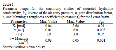
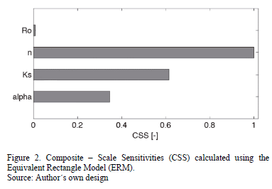
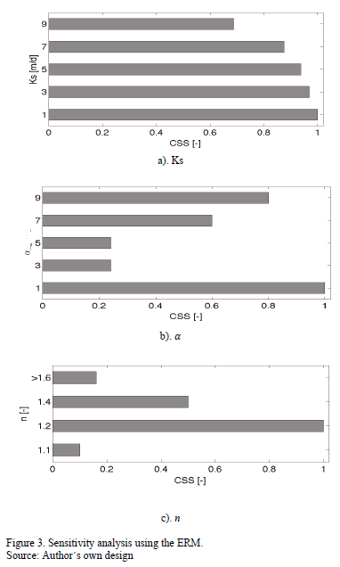
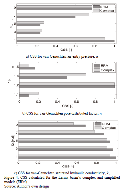
<body><![CDATA[<p align="center"><font size="2" face="Verdana, Arial, Helvetica, sans-serif"><a name="fig01"></a></font><img src="/img/revistas/dyna/v83n199/v83n199a06fig01.gif"></p>     <p><font size="2" face="Verdana, Arial, Helvetica, sans-serif">The parameters chosen for the parameterization process  are hydraulic conductivity (<img src="/img/revistas/dyna/v83n199/v83n199a06eq082.gif">), the van Genuchten  parameters,</font> <font size="2" face="Verdana, Arial, Helvetica, sans-serif">inverse air entry  pressure (<font face="Symbol">a</font>), and pore distribution factor (<i>n</i>). The Manning's roughness coefficient (<img src="/img/revistas/dyna/v83n199/v83n199a06eq092.gif">) was also being investigated. <a href="#tab01">Table 1</a> presents the range of the  parameter values and the perturbation (<img src="/img/revistas/dyna/v83n199/v83n199a06eq016.gif">) used for each parameter (<img src="/img/revistas/dyna/v83n199/v83n199a06eq094.gif">) in the sensitivity analysis. When this analysis was performed,  only physical values of the soils and predominant land-use within Lerma basin &#91;9&#93; were  tested.</font></p>     <p align="center"><font size="2" face="Verdana, Arial, Helvetica, sans-serif"><a name="tab01"></a></font><img src="/img/revistas/dyna/v83n199/v83n199a06tab01.gif"></p>     <p><font size="2" face="Verdana, Arial, Helvetica, sans-serif">The first step in the parameterization  process is to define the parameters that have a relevant effect on the  hydrological response of the watershed. Thus, we undertook a sensitivity assess  and then a ranking parameter (i.e. <i>ks</i>, <font face="Symbol">a</font>, <i>n </i>and <i>Ro</i>)  was calculated using the ERM. Larger CSS values indicate parameters that are  more meaningful. CSS' <a href="#fig02">Fig 2</a>. presents the CSS normalized ranking, and it can be  observed that the CSS value for Manning's roughness coefficient is very low  compared to <i>ks</i>, <font face="Symbol">a</font>, and <i>n</i>; this is also detailed in Perez et al. &#91;19&#93;. Hence, the  parameterization exercise presented in this paper focused on the remaining  three parameters (<i>ks</i>, <font face="Symbol">a</font>, and <i>n</i>). It is important to mention that the values of <i>Ro</i> used ranged from 0.03 to 0.05 as  these values correspond to values are typically presented in the literature in  terms of the cropping patterns associated with the Lerma Basin.</font></p>     <p align="center"><font size="2" face="Verdana, Arial, Helvetica, sans-serif"><a name="fig02"></a></font><img src="/img/revistas/dyna/v83n199/v83n199a06fig02.gif"></p>     <p><font size="2" face="Verdana, Arial, Helvetica, sans-serif">In order to speed up the calibration, it  is important to narrow down the dimension of the significant parameter space  and set the range for which the parameters are sensitive. In order to do this,  we used multiple simulations with different parameter value combinations for<img src="/img/revistas/dyna/v83n199/v83n199a06eq096.gif">, <font face="Symbol">a</font>, and <i>n</i>. We  calculated CSS values for each range of parameters, we assumed the weighting  factor (<font face="Symbol">w</font>) to be the inverse of the measurement error matrix (<img src="/img/revistas/dyna/v83n199/v83n199a06eq098.gif">), and we set a relative error of 10% for the discharge measurements. The results provided a ranking for each  parameter that shows the variation of the sensitivity in the parameter space  (see <a href="#fig03">Fig 3</a>). This helps to reduce the parameter range for calibration and  consequently the computational times. For the three rankings, it is possible to  observe values for which the sensibility on the model output is higher. </font></p>     <p align="center"><font size="2" face="Verdana, Arial, Helvetica, sans-serif"><a name="fig03" id="fig03"></a></font><img src="/img/revistas/dyna/v83n199/v83n199a06fig03.gif"></p>     <p><font size="2" face="Verdana, Arial, Helvetica, sans-serif">To demonstrate the applicability of the  ERM, the sensitivity study (CSS) was also performed using the 3-D fully coupled  model of the Lerma basin with more than 200,000 elements. For a comparable  analysis between these two models, the homogeneous glacis was also assumed in  the complex model. The CSS was calculated as having equivalent conditions to  those used in the ERM, i.e. having equivalent combinations of parameter values,  precipitation, evapotranspiration, and irrigation data. The results of the CSS  values for the ERM and the 3-D fully-coupled model are shown in <a href="#fig04">Fig 4</a>.</font></p>     <p align="center"><font size="2" face="Verdana, Arial, Helvetica, sans-serif"><a name="fig04"></a></font><img src="/img/revistas/dyna/v83n199/v83n199a06fig04.gif"></p>     <p><font size="2" face="Verdana, Arial, Helvetica, sans-serif">The calculated CSS values for both models  are very similar and they show the applicability of the simplification on  parameter studies. According to the  figure, values of CSS for the inverse of the air-entry pressure, <font face="Symbol">a</font>, are higher (around 1). They decrease around 3 and 5 and increase again for higher  values of <font face="Symbol">a</font>. CSS for <i>n</i> show higher values around <img src="/img/revistas/dyna/v83n199/v83n199a06eq100.gif">. CSS values decrease for  higher values of n. For the case of <img src="/img/revistas/dyna/v83n199/v83n199a06eq102.gif">CSS values slightly  decrease when of <img src="/img/revistas/dyna/v83n199/v83n199a06eq082.gif"> values increase.</font></p>     ]]></body>
<body><![CDATA[<p><font size="2" face="Verdana, Arial, Helvetica, sans-serif">To further investigate the applicability  of the ERM, the model is used in the Lerma basin calibration process. &#91;2&#93; proposed a calibration of the Lerma basin, but as it is highlighted by &#91;3&#93;, the  approach presented is slow. In this study, the ERM is used to speed-up the  calibration process. </font></p>     <p><font size="2" face="Verdana, Arial, Helvetica, sans-serif">To calibrate the model, instead of using  the complex model the ERM was used. Also, values of the calibration parameters  (i.e. k<sub>s</sub>, <font face="Symbol">a</font>, and n) were systematically changed by using an  automatic approach performed using the software PEST &#91;22&#93; within the pre-defined ranges. This was undertaken until a reasonably good  performance of the model, compared to the measured data, was found. To improve  the agreement between simulated and measured data, the set of calibrated  parameters obtained using the ERM was introduced to the complex model. Five  more iterations were then needed to achieve the model's best performance. </font></p>     <p><font size="2" face="Verdana, Arial, Helvetica, sans-serif">While with the original approach (using  the complex model) more than 100 manual iterations that took 50,000 minutes  were needed to achieve the best performance, the approach using the ERM that  included more than 1000 automatic iterations and five iterations with the  complex model only took less than 7000 minutes. This reduction in the time  required to calibrate the model was more than 700%.</font></p>     <p><font size="2" face="Verdana, Arial, Helvetica, sans-serif">In <a href="#fig05">Fig 5</a>, the evolution of the  performance of the model expressed as the ratio <i><font face="Symbol">C</font><sup>2</sup></i>/DoF is presented. As is shown, the optimal value of the ratio  (best performance of the model) was reached after 1000 automatic iterations  using the ERM model and five more iterations using the complex model.</font></p>     <p align="center"><font size="2" face="Verdana, Arial, Helvetica, sans-serif"><a name="fig05"></a></font><img src="/img/revistas/dyna/v83n199/v83n199a06fig05.gif"></p>     <p><font size="2" face="Verdana, Arial, Helvetica, sans-serif">Calibrated values obtained for the glacis  formation were <img src="/img/revistas/dyna/v83n199/v83n199a06eq104.gif">, <img src="/img/revistas/dyna/v83n199/v83n199a06eq106.gif">, and <img src="/img/revistas/dyna/v83n199/v83n199a06eq108.gif">; and for the buro formation <img src="/img/revistas/dyna/v83n199/v83n199a06eq110.gif">, <img src="/img/revistas/dyna/v83n199/v83n199a06eq112.gif">, and <img src="/img/revistas/dyna/v83n199/v83n199a06eq114.gif">, are very close to the  average calibrated values reported by &#91;2,3&#93; for the glacis and the buro. </font></p>     <p>&nbsp;</p>     <p><font size="3" face="Verdana, Arial, Helvetica, sans-serif"><b>5. Conclusions</b></font></p>     <p><font size="2" face="Verdana, Arial, Helvetica, sans-serif">The reduction in running times with the  simplification of the watershed geometry is significant: while a single run  with the 3-D fully-coupled model of the Lerma basin takes between 420 and 600  minutes, for the ERM it only takes between 3 and 8 minutes. This means, that  for a sensitivity study of a physics-based superficial-subsuperficial model for  a one year simulation of the Lerma basin (around 1000 runs) using a single 1.3  GHz Intel Core i5 computer, it would take around 300 days to obtain representative  results. With the ERM, it would take less than four days using a computer with  the same specifications. The situation appears to be worse when more layers are  used, as well as when feedbacks between soil moisture and evapotranspiration  are used as simulations for more than 37 hours for a single run and they have been reported for the same basin &#91;3&#93;. </font></p>     <p><font size="2" face="Verdana, Arial, Helvetica, sans-serif">Simplification of the geometry of the  basin using the rectangle equivalent concept appears to be a good approximation  to speed up the calibration of 3-D fully-coupled, physics-based models.</font></p>     ]]></body>

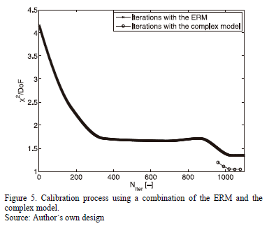
<body><![CDATA[<p><font size="2" face="Verdana, Arial, Helvetica, sans-serif">By speeding up the process, the ERM may  also help to reduce subjectivity during the calibration, promote the use of  more appropriate automatic algorithms, and improve the performance of  physics-based, fully-coupled hydrologic models.</font></p>     <p><font size="2" face="Verdana, Arial, Helvetica, sans-serif">Results suggest that the ERM may be  applied for small to moderate catchments where the slope denotes an important  feature in the basin and it can be represented without taking into account  lateral variation in the geology.</font></p>     <p>&nbsp;</p>     <p><font size="3" face="Verdana, Arial, Helvetica, sans-serif"><b>References</b></font></p>     <!-- ref --><p><font size="2" face="Verdana, Arial, Helvetica, sans-serif"><b>&#91;1&#93;</b> Refsgaard, J. and Storm, B., Construction, calibration  and validation of hydrological models. Distributed hydrological modelling. pp.  41-54 69-97, 1996.    &nbsp;&nbsp;&nbsp;&nbsp;&nbsp;&nbsp;&nbsp;&nbsp;[&#160;<a href="javascript:void(0);" onclick="javascript: window.open('/scielo.php?script=sci_nlinks&ref=1149953&pid=S0012-7353201600050000600001&lng=','','width=640,height=500,resizable=yes,scrollbars=1,menubar=yes,');">Links</a>&#160;]<!-- end-ref --> </font></p>     <!-- ref --><p><font size="2" face="Verdana, Arial, Helvetica, sans-serif"><b>&#91;2&#93;</b> P&eacute;rez, A.J., Abrahão, R., Causap&eacute;, J., Cirpka, O. and  Bürger, C., Simulating the transition of a semi-arid rainfed catchment towards  irrigation agriculture. J Hydrol., 409(3), pp. 663-681, 2011. DOI:  10.1016/j.jhydrol.2011.08.061.    &nbsp;&nbsp;&nbsp;&nbsp;&nbsp;&nbsp;&nbsp;&nbsp;[&#160;<a href="javascript:void(0);" onclick="javascript: window.open('/scielo.php?script=sci_nlinks&ref=1149955&pid=S0012-7353201600050000600002&lng=','','width=640,height=500,resizable=yes,scrollbars=1,menubar=yes,');">Links</a>&#160;]<!-- end-ref --> </font></p>     <!-- ref --><p><font size="2" face="Verdana, Arial, Helvetica, sans-serif"><b>&#91;3&#93;</b> Von Gunten, D., Wöhling, T., Haslauer, C., Merch&aacute;n, D.,  Causap&eacute;, J. and Cirpka, O.A., Efficient calibration of a distributed pde-based  hydrological model using grid coarsening. J Hydrol., 519, pp. 3290-2304, 2014.  DOI: 10.1016/j.jhydrol.2014.10.025.    &nbsp;&nbsp;&nbsp;&nbsp;&nbsp;&nbsp;&nbsp;&nbsp;[&#160;<a href="javascript:void(0);" onclick="javascript: window.open('/scielo.php?script=sci_nlinks&ref=1149957&pid=S0012-7353201600050000600003&lng=','','width=640,height=500,resizable=yes,scrollbars=1,menubar=yes,');">Links</a>&#160;]<!-- end-ref --> </font></p>     ]]></body>
<body><![CDATA[<!-- ref --><p><font size="2" face="Verdana, Arial, Helvetica, sans-serif"><b>&#91;4&#93;</b> Li, Q., Unger, A.J.A., Sudicky, E.A., Kassenaar, D,  Wexler, E.J. and Shikaze, S., Simulating the multi-seasonal response of a  large-scale watershed with a 3D physically-based hydrologic model. J Hydrol.,  357(3), pp. 317-336, 2008. DOI: 10.1016/j.jhydrol.2008.05.024.    &nbsp;&nbsp;&nbsp;&nbsp;&nbsp;&nbsp;&nbsp;&nbsp;[&#160;<a href="javascript:void(0);" onclick="javascript: window.open('/scielo.php?script=sci_nlinks&ref=1149959&pid=S0012-7353201600050000600004&lng=','','width=640,height=500,resizable=yes,scrollbars=1,menubar=yes,');">Links</a>&#160;]<!-- end-ref --> </font></p>     <!-- ref --><p><font size="2" face="Verdana, Arial, Helvetica, sans-serif"><b>&#91;5&#93;</b> Maxwell, R.M. and Kollet, S.J., Quantifying the  effects of three-dimensional subsurface heterogeneity on Hortonian runoff  processes using a coupled numerical, stochastic approach. Adv Water Resour.,  31(5), pp. 807-817, 2008. DOI: 10.1016/j.advwatres.2008.01.020.    &nbsp;&nbsp;&nbsp;&nbsp;&nbsp;&nbsp;&nbsp;&nbsp;[&#160;<a href="javascript:void(0);" onclick="javascript: window.open('/scielo.php?script=sci_nlinks&ref=1149961&pid=S0012-7353201600050000600005&lng=','','width=640,height=500,resizable=yes,scrollbars=1,menubar=yes,');">Links</a>&#160;]<!-- end-ref --> </font></p>     <!-- ref --><p><font size="2" face="Verdana, Arial, Helvetica, sans-serif"><b>&#91;6&#93;</b> Smerdon, B.D., Mendoza, C.A. and Devito, K.J., Simulations  of fully coupled lake-groundwater exchange in a subhumid climate with an  integrated hydrologic model. Water Resour Res &#91;Online&#93;., 43(1), 2007 &#91;cited  2016 Aug 5&#93;. DOI: 10.1029/2006WR005137.    &nbsp;&nbsp;&nbsp;&nbsp;&nbsp;&nbsp;&nbsp;&nbsp;[&#160;<a href="javascript:void(0);" onclick="javascript: window.open('/scielo.php?script=sci_nlinks&ref=1149963&pid=S0012-7353201600050000600006&lng=','','width=640,height=500,resizable=yes,scrollbars=1,menubar=yes,');">Links</a>&#160;]<!-- end-ref --> </font></p>     <!-- ref --><p><font size="2" face="Verdana, Arial, Helvetica, sans-serif"><b>&#91;7&#93;</b> Dong, Q., Xu, D., Zhang, S., Bai, M. and Li, Y., A hybrid  coupled model of surface and subsurface flow for surface irrigation. J Hydrol.,  500, pp. 62-74, 2013. DOI: 10.1016/j.jhydrol.2013.07.018.    &nbsp;&nbsp;&nbsp;&nbsp;&nbsp;&nbsp;&nbsp;&nbsp;[&#160;<a href="javascript:void(0);" onclick="javascript: window.open('/scielo.php?script=sci_nlinks&ref=1149965&pid=S0012-7353201600050000600007&lng=','','width=640,height=500,resizable=yes,scrollbars=1,menubar=yes,');">Links</a>&#160;]<!-- end-ref --> </font></p>     <!-- ref --><p><font size="2" face="Verdana, Arial, Helvetica, sans-serif"><b>&#91;8&#93;</b> Weill, S., Mazzia, A., Putti, M. and Paniconi, C.,  Coupling water flow and solute transport into a physically-based  surface-subsurface hydrological model. Adv Water Resour., 34(1), pp. 128-136,  2011. DOI: 10.1016/j.advwatres.2010.10.001.    &nbsp;&nbsp;&nbsp;&nbsp;&nbsp;&nbsp;&nbsp;&nbsp;[&#160;<a href="javascript:void(0);" onclick="javascript: window.open('/scielo.php?script=sci_nlinks&ref=1149967&pid=S0012-7353201600050000600008&lng=','','width=640,height=500,resizable=yes,scrollbars=1,menubar=yes,');">Links</a>&#160;]<!-- end-ref --> </font></p>     ]]></body>
<body><![CDATA[<!-- ref --><p><font size="2" face="Verdana, Arial, Helvetica, sans-serif"><b>&#91;9&#93;</b> Tian, Y., Zheng, Y., Wu, B., Wu, X., Liu, J. and Zheng,  C., Modeling surface water-groundwater interaction in arid and semi-arid regions  with intensive agriculture. Environ Model Softw., 63, pp. 170-184, 2015. DOI:  10.1016/j.envsoft.2014.10.011.    &nbsp;&nbsp;&nbsp;&nbsp;&nbsp;&nbsp;&nbsp;&nbsp;[&#160;<a href="javascript:void(0);" onclick="javascript: window.open('/scielo.php?script=sci_nlinks&ref=1149969&pid=S0012-7353201600050000600009&lng=','','width=640,height=500,resizable=yes,scrollbars=1,menubar=yes,');">Links</a>&#160;]<!-- end-ref --> </font></p>     <!-- ref --><p><font size="2" face="Verdana, Arial, Helvetica, sans-serif"><b>&#91;10&#93;</b> Freeze, R.A. and Harlan, R.L., Blueprint for a  physically-based, digitally-simulated hydrologic response model. J Hydrol.,  9(3), pp. 237-258, 1969. DOI: 10.1016/0022-1694(69)90020-1.    &nbsp;&nbsp;&nbsp;&nbsp;&nbsp;&nbsp;&nbsp;&nbsp;[&#160;<a href="javascript:void(0);" onclick="javascript: window.open('/scielo.php?script=sci_nlinks&ref=1149971&pid=S0012-7353201600050000600010&lng=','','width=640,height=500,resizable=yes,scrollbars=1,menubar=yes,');">Links</a>&#160;]<!-- end-ref --> </font></p>     <!-- ref --><p><font size="2" face="Verdana, Arial, Helvetica, sans-serif"><b>&#91;11&#93;</b> Panday, S. and Huyakorn, P.S., A fully coupled  physically-based spatially-distributed model for evaluating surface/subsurface  flow. Adv Water Resour., 27(4), pp. 361-382, 2004. DOI: 10.1016/j.advwatres.2004.02.016.    &nbsp;&nbsp;&nbsp;&nbsp;&nbsp;&nbsp;&nbsp;&nbsp;[&#160;<a href="javascript:void(0);" onclick="javascript: window.open('/scielo.php?script=sci_nlinks&ref=1149973&pid=S0012-7353201600050000600011&lng=','','width=640,height=500,resizable=yes,scrollbars=1,menubar=yes,');">Links</a>&#160;]<!-- end-ref --> </font></p>     <!-- ref --><p><font size="2" face="Verdana, Arial, Helvetica, sans-serif"><b>&#91;12&#93;</b> VanderKwaak, J.E.,  Numerical simulation of flow and chemical transport in integrated  surface-subsurface hydrologic systems. University  of Waterloo, 1999.    &nbsp;&nbsp;&nbsp;&nbsp;&nbsp;&nbsp;&nbsp;&nbsp;[&#160;<a href="javascript:void(0);" onclick="javascript: window.open('/scielo.php?script=sci_nlinks&ref=1149975&pid=S0012-7353201600050000600012&lng=','','width=640,height=500,resizable=yes,scrollbars=1,menubar=yes,');">Links</a>&#160;]<!-- end-ref --> </font></p>     <!-- ref --><p><font size="2" face="Verdana, Arial, Helvetica, sans-serif"><b>&#91;13&#93;</b> Poeter, E.P., Hill MC. UCODE, A computer code for  universal inverse modeling. Comput Geosci., 25(4), pp. 457-462, 1999. DOI:  10.1016/S0098-3004(98)00149-6.    &nbsp;&nbsp;&nbsp;&nbsp;&nbsp;&nbsp;&nbsp;&nbsp;[&#160;<a href="javascript:void(0);" onclick="javascript: window.open('/scielo.php?script=sci_nlinks&ref=1149977&pid=S0012-7353201600050000600013&lng=','','width=640,height=500,resizable=yes,scrollbars=1,menubar=yes,');">Links</a>&#160;]<!-- end-ref --> </font></p>     ]]></body>
<body><![CDATA[<!-- ref --><p><font size="2" face="Verdana, Arial, Helvetica, sans-serif"><b>&#91;14&#93;</b> P&eacute;rez-Garc&iacute;a, A., Physics-based numerical modeling of  surface-groundwater flow and transport at catchment scale. Universität Tübingen,  2011.    &nbsp;&nbsp;&nbsp;&nbsp;&nbsp;&nbsp;&nbsp;&nbsp;[&#160;<a href="javascript:void(0);" onclick="javascript: window.open('/scielo.php?script=sci_nlinks&ref=1149979&pid=S0012-7353201600050000600014&lng=','','width=640,height=500,resizable=yes,scrollbars=1,menubar=yes,');">Links</a>&#160;]<!-- end-ref --> </font></p>     <!-- ref --><p><font size="2" face="Verdana, Arial, Helvetica, sans-serif"><b>&#91;15&#93;</b> Van Griensven, A., Meixner, T., Grunwald, S., Bishop,  T., Diluzio, M. and Srinivasan, R., A global sensitivity analysis tool for the  parameters of multi-variable catchment models. J Hydrol., 324(1-4), pp. 10-23,  2006. DOI: 10.1016/j.jhydrol.2005.09.008.    &nbsp;&nbsp;&nbsp;&nbsp;&nbsp;&nbsp;&nbsp;&nbsp;[&#160;<a href="javascript:void(0);" onclick="javascript: window.open('/scielo.php?script=sci_nlinks&ref=1149981&pid=S0012-7353201600050000600015&lng=','','width=640,height=500,resizable=yes,scrollbars=1,menubar=yes,');">Links</a>&#160;]<!-- end-ref --> </font></p>     <!-- ref --><p><font size="2" face="Verdana, Arial, Helvetica, sans-serif"><b>&#91;16&#93;</b> Hill, M.C., A computer program (MODFLOWP) for estimating  parameters of a transient, three-dimensional ground-water flow model using  nonlinear regression. In Denver, Colorado, 1992.    &nbsp;&nbsp;&nbsp;&nbsp;&nbsp;&nbsp;&nbsp;&nbsp;[&#160;<a href="javascript:void(0);" onclick="javascript: window.open('/scielo.php?script=sci_nlinks&ref=1149983&pid=S0012-7353201600050000600016&lng=','','width=640,height=500,resizable=yes,scrollbars=1,menubar=yes,');">Links</a>&#160;]<!-- end-ref --> </font></p>     <!-- ref --><p><font size="2" face="Verdana, Arial, Helvetica, sans-serif"><b>&#91;17&#93;</b> Hill, M.C., Comment on Two statistics for evaluating  parameter identifiability and error reduction, by John Doherty and Randall J.  Hunt. J Hydrol., 380(3-4), pp. 481-488, 2010. DOI:  10.1016/j.jhydrol.2009.10.011.    &nbsp;&nbsp;&nbsp;&nbsp;&nbsp;&nbsp;&nbsp;&nbsp;[&#160;<a href="javascript:void(0);" onclick="javascript: window.open('/scielo.php?script=sci_nlinks&ref=1149985&pid=S0012-7353201600050000600017&lng=','','width=640,height=500,resizable=yes,scrollbars=1,menubar=yes,');">Links</a>&#160;]<!-- end-ref --> </font></p>     <!-- ref --><p><font size="2" face="Verdana, Arial, Helvetica, sans-serif"><b>&#91;18&#93;</b> Roche, M.,  Hydrologie de surface. Paris, France: Gauthier-Villars et ORSTOM, 1963.    &nbsp;&nbsp;&nbsp;&nbsp;&nbsp;&nbsp;&nbsp;&nbsp;[&#160;<a href="javascript:void(0);" onclick="javascript: window.open('/scielo.php?script=sci_nlinks&ref=1149987&pid=S0012-7353201600050000600018&lng=','','width=640,height=500,resizable=yes,scrollbars=1,menubar=yes,');">Links</a>&#160;]<!-- end-ref --> </font></p>     ]]></body>
<body><![CDATA[<!-- ref --><p><font size="2" face="Verdana, Arial, Helvetica, sans-serif"><b>&#91;19&#93;</b> Perez, A.J., Abrahao, R., Causape, J., Cirpka, O.A.  and Claudius, M.B., Implications of diffusive wave cascading plane simulations  for the study of surface water - groundwater interaction with a 3-D fully -  integrated catchment model. In: XVIII International Conference on Water  Resources. Barcelona, 2010.    &nbsp;&nbsp;&nbsp;&nbsp;&nbsp;&nbsp;&nbsp;&nbsp;[&#160;<a href="javascript:void(0);" onclick="javascript: window.open('/scielo.php?script=sci_nlinks&ref=1149989&pid=S0012-7353201600050000600019&lng=','','width=640,height=500,resizable=yes,scrollbars=1,menubar=yes,');">Links</a>&#160;]<!-- end-ref --> </font></p>     <!-- ref --><p><font size="2" face="Verdana, Arial, Helvetica, sans-serif"><b>&#91;20&#93;</b> Carsel, R.F. and Parrish, R.S., Developing joint  probability distributions of soil water retention characteristics. Water Resour  Res., 24(5), pp. 755-769, 1988. DOI: 10.1029/WR024i005p00755.    &nbsp;&nbsp;&nbsp;&nbsp;&nbsp;&nbsp;&nbsp;&nbsp;[&#160;<a href="javascript:void(0);" onclick="javascript: window.open('/scielo.php?script=sci_nlinks&ref=1149991&pid=S0012-7353201600050000600020&lng=','','width=640,height=500,resizable=yes,scrollbars=1,menubar=yes,');">Links</a>&#160;]<!-- end-ref --> </font></p>     <!-- ref --><p><font size="2" face="Verdana, Arial, Helvetica, sans-serif"><b>&#91;21&#93;</b> Delfs, J-O, Park, C-H, Kolditz, O., A sensitivity  analysis of Hortonian flow. Adv Water Resour., 32(9), pp. 1386-1395, 2009. DOI:  10.1016/j.advwatres.2009.06.005.    &nbsp;&nbsp;&nbsp;&nbsp;&nbsp;&nbsp;&nbsp;&nbsp;[&#160;<a href="javascript:void(0);" onclick="javascript: window.open('/scielo.php?script=sci_nlinks&ref=1149993&pid=S0012-7353201600050000600021&lng=','','width=640,height=500,resizable=yes,scrollbars=1,menubar=yes,');">Links</a>&#160;]<!-- end-ref --> </font></p>     <!-- ref --><p><font size="2" face="Verdana, Arial, Helvetica, sans-serif"><b>&#91;22&#93;</b> Moore, C. and Doherty, J., Role of the calibration  process in reducing model predictive error. Water Resour Res., 41(5), pp. 1-14,  2005. DOI: 10.1029/2004WR003501.    &nbsp;&nbsp;&nbsp;&nbsp;&nbsp;&nbsp;&nbsp;&nbsp;[&#160;<a href="javascript:void(0);" onclick="javascript: window.open('/scielo.php?script=sci_nlinks&ref=1149995&pid=S0012-7353201600050000600022&lng=','','width=640,height=500,resizable=yes,scrollbars=1,menubar=yes,');">Links</a>&#160;]<!-- end-ref --> </font></p>     <p>&nbsp;</p>     <p><font size="2" face="Verdana, Arial, Helvetica, sans-serif"><b>J. Causap&eacute;, </b>is a geological scientist  who studied at the Universidad de Zaragoza, Spain and has a PhD. in Geosciences  from the same University. He was associated professor at the Universidad de  Zaragoza between 2002-2003 and a Postdoc fellow at the University of  Wageningen, Netherlands and Universidad Politecnica de Catalunya, Spain,  between 2004 and 2006. In 2008, he joined the Instituto Geol&oacute;gico Minero de  Espa&ntilde;a (IGME), as associated researcher in hydrogeology and environmental  quality, where he has conducted several research projects and published more  than 40 papers. ORCID: 0000-0002-9165-9710.</font></p>     ]]></body>
<body><![CDATA[<p><font size="2" face="Verdana, Arial, Helvetica, sans-serif"><b>R. Abrahao, </b>his BSc. degree in  Agricultural Engineering in 2004 from the Universidade Federal de Campina  Grande, Brazil and his MSc. degree in 2006 from the Universidade Federal de  Paraiba, Brazil. In 2011, he was awarded his PhD. in Chemical Engineering from  the Universidad de Zaragoza, Spain. Since 2012 he has been working as professor  at the Universidade Federal de Paraiba. He has published more than 20 papers and  participated in more than 40 events. ORCID: 0000-0002-2945-2604.</font></p>     <p><font size="2" face="Verdana, Arial, Helvetica, sans-serif"><b>A.J. Perez, </b>received his BSc. in Civil  Engineering from the Universidad Javeriana, Colombia. He was awarded his MSc.  from the same university and wrote his thesis on geostatistics in hydrogeology.  Subsequently, he joined the environmental engineering Department at the  Universidad Antonio Nari&ntilde;o, Colombia and lectured on water resources and  numerical modeling. In 2007, he started his PhD. and joined the Hydrogeology  group at the Center of Applied Geosciences at the University of Tübingen,  Germany. In 2011, he was awarded his PhD and his thesis was based on  physics-based numerical modeling on catchment scale. He has currently been  working as assistant professor at the Universidad Antonio Nari&ntilde;o, Colombia and  consultant specialist of the Colombian Government in water resources-related  matters. ORCID: 0000-0001-5581-013X</font></p>     <p><font size="2" face="Verdana, Arial, Helvetica, sans-serif"><b>J. Hurtado-Pati&ntilde;o, </b>her BSc. in  Environmental Engineering degree from the Universidad de Los Andes, Colombia.  She worked as a young researcher in the field of anaerobic bioreactors for the  treatment of industrial wastewater in the Environment Research Center - CIIA at  the Universidad de Los Andes, Colombia. She also has experience in  environmental consulting focused on prevention and mitigation of environmental  impact for public and private industries. She is currently working as a  graduate assistant researcher at the Universidad Antonio Nari&ntilde;o, Colombia. ORCID: 0000-0001-6257-7081.</font></p>      ]]></body><back>
<ref-list>
<ref id="B1">
<label>1</label><nlm-citation citation-type="journal">
<person-group person-group-type="author">
<name>
<surname><![CDATA[Refsgaard]]></surname>
<given-names><![CDATA[J.]]></given-names>
</name>
<name>
<surname><![CDATA[Storm]]></surname>
<given-names><![CDATA[B.]]></given-names>
</name>
</person-group>
<article-title xml:lang="en"><![CDATA[Construction, calibration and validation of hydrological models.]]></article-title>
<source><![CDATA[Distributed hydrological modelling]]></source>
<year>1996</year>
<page-range>41-54</page-range><page-range>69-97</page-range></nlm-citation>
</ref>
<ref id="B2">
<label>2</label><nlm-citation citation-type="journal">
<person-group person-group-type="author">
<name>
<surname><![CDATA[Pérez]]></surname>
<given-names><![CDATA[A.J.]]></given-names>
</name>
<name>
<surname><![CDATA[Abrahão]]></surname>
<given-names><![CDATA[R.]]></given-names>
</name>
<name>
<surname><![CDATA[Causapé]]></surname>
<given-names><![CDATA[J.]]></given-names>
</name>
<name>
<surname><![CDATA[Cirpka]]></surname>
<given-names><![CDATA[O.]]></given-names>
</name>
<name>
<surname><![CDATA[Bürger]]></surname>
<given-names><![CDATA[C.]]></given-names>
</name>
</person-group>
<article-title xml:lang="en"><![CDATA[Simulating the transition of a semi-arid rainfed catchment towards irrigation agriculture]]></article-title>
<source><![CDATA[J Hydrol.]]></source>
<year>2011</year>
<volume>409</volume>
<numero>3</numero>
<issue>3</issue>
<page-range>663-681</page-range></nlm-citation>
</ref>
<ref id="B3">
<label>3</label><nlm-citation citation-type="journal">
<person-group person-group-type="author">
<name>
<surname><![CDATA[Von Gunten]]></surname>
<given-names><![CDATA[D.]]></given-names>
</name>
<name>
<surname><![CDATA[Wöhling]]></surname>
<given-names><![CDATA[T.]]></given-names>
</name>
<name>
<surname><![CDATA[Haslauer]]></surname>
<given-names><![CDATA[C.]]></given-names>
</name>
<name>
<surname><![CDATA[Merchán]]></surname>
<given-names><![CDATA[D.]]></given-names>
</name>
<name>
<surname><![CDATA[Causapé]]></surname>
<given-names><![CDATA[J.]]></given-names>
</name>
<name>
<surname><![CDATA[Cirpka]]></surname>
<given-names><![CDATA[O.A.]]></given-names>
</name>
</person-group>
<article-title xml:lang="en"><![CDATA[Efficient calibration of a distributed pde-based hydrological model using grid coarsening]]></article-title>
<source><![CDATA[J Hydrol.]]></source>
<year>2014</year>
<numero>519</numero>
<issue>519</issue>
<page-range>3290-2304</page-range></nlm-citation>
</ref>
<ref id="B4">
<label>4</label><nlm-citation citation-type="journal">
<person-group person-group-type="author">
<name>
<surname><![CDATA[Li]]></surname>
<given-names><![CDATA[Q.]]></given-names>
</name>
<name>
<surname><![CDATA[Unger]]></surname>
<given-names><![CDATA[A.J.A.]]></given-names>
</name>
<name>
<surname><![CDATA[Sudicky]]></surname>
<given-names><![CDATA[E.A.]]></given-names>
</name>
<name>
<surname><![CDATA[Kassenaar]]></surname>
<given-names><![CDATA[D]]></given-names>
</name>
<name>
<surname><![CDATA[Wexler]]></surname>
<given-names><![CDATA[E.J.]]></given-names>
</name>
<name>
<surname><![CDATA[Shikaze]]></surname>
<given-names><![CDATA[S.]]></given-names>
</name>
</person-group>
<article-title xml:lang="en"><![CDATA[Simulating the multi-seasonal response of a large-scale watershed with a 3D physically-based hydrologic model.]]></article-title>
<source><![CDATA[J Hydrol.]]></source>
<year>2008</year>
<volume>357</volume>
<numero>3</numero>
<issue>3</issue>
<page-range>317-336</page-range></nlm-citation>
</ref>
<ref id="B5">
<label>5</label><nlm-citation citation-type="journal">
<person-group person-group-type="author">
<name>
<surname><![CDATA[Maxwell]]></surname>
<given-names><![CDATA[R.M.]]></given-names>
</name>
<name>
<surname><![CDATA[Kollet]]></surname>
<given-names><![CDATA[S.J.]]></given-names>
</name>
</person-group>
<article-title xml:lang="en"><![CDATA[Quantifying the effects of three-dimensional subsurface heterogeneity on Hortonian runoff processes using a coupled numerical, stochastic approach.]]></article-title>
<source><![CDATA[Adv Water Resour.]]></source>
<year>2008</year>
<volume>31</volume>
<numero>5</numero>
<issue>5</issue>
<page-range>807-817</page-range></nlm-citation>
</ref>
<ref id="B6">
<label>6</label><nlm-citation citation-type="journal">
<person-group person-group-type="author">
<name>
<surname><![CDATA[Smerdon]]></surname>
<given-names><![CDATA[B.D.]]></given-names>
</name>
<name>
<surname><![CDATA[Mendoza]]></surname>
<given-names><![CDATA[C.A.]]></given-names>
</name>
<name>
<surname><![CDATA[Devito]]></surname>
<given-names><![CDATA[K.J.]]></given-names>
</name>
</person-group>
<article-title xml:lang="en"><![CDATA[Simulations of fully coupled lake-groundwater exchange in a subhumid climate with an integrated hydrologic model]]></article-title>
<source><![CDATA[Water Resour Res]]></source>
<year>2007</year>
<volume>43</volume>
<numero>1</numero>
<issue>1</issue>
</nlm-citation>
</ref>
<ref id="B7">
<label>7</label><nlm-citation citation-type="journal">
<person-group person-group-type="author">
<name>
<surname><![CDATA[Dong]]></surname>
<given-names><![CDATA[Q.]]></given-names>
</name>
<name>
<surname><![CDATA[Xu]]></surname>
<given-names><![CDATA[D.]]></given-names>
</name>
<name>
<surname><![CDATA[Zhang]]></surname>
<given-names><![CDATA[S.]]></given-names>
</name>
<name>
<surname><![CDATA[Bai]]></surname>
<given-names><![CDATA[M.]]></given-names>
</name>
<name>
<surname><![CDATA[Li]]></surname>
<given-names><![CDATA[Y.]]></given-names>
</name>
</person-group>
<article-title xml:lang="en"><![CDATA[A hybrid coupled model of surface and subsurface flow for surface irrigation]]></article-title>
<source><![CDATA[J Hydrol.]]></source>
<year>2013</year>
<numero>500</numero>
<issue>500</issue>
<page-range>62-74</page-range></nlm-citation>
</ref>
<ref id="B8">
<label>8</label><nlm-citation citation-type="journal">
<person-group person-group-type="author">
<name>
<surname><![CDATA[Weill]]></surname>
<given-names><![CDATA[S.]]></given-names>
</name>
<name>
<surname><![CDATA[Mazzia]]></surname>
<given-names><![CDATA[A.]]></given-names>
</name>
<name>
<surname><![CDATA[Putti]]></surname>
<given-names><![CDATA[M.]]></given-names>
</name>
<name>
<surname><![CDATA[Paniconi]]></surname>
<given-names><![CDATA[C.]]></given-names>
</name>
</person-group>
<article-title xml:lang="en"><![CDATA[Coupling water flow and solute transport into a physically-based surface-subsurface hydrological model]]></article-title>
<source><![CDATA[Adv Water Resour.]]></source>
<year>2011</year>
<volume>34</volume>
<numero>1</numero>
<issue>1</issue>
<page-range>128-136</page-range></nlm-citation>
</ref>
<ref id="B9">
<label>9</label><nlm-citation citation-type="journal">
<person-group person-group-type="author">
<name>
<surname><![CDATA[Tian]]></surname>
<given-names><![CDATA[Y.]]></given-names>
</name>
<name>
<surname><![CDATA[Zheng]]></surname>
<given-names><![CDATA[Y.]]></given-names>
</name>
<name>
<surname><![CDATA[Wu]]></surname>
<given-names><![CDATA[B.]]></given-names>
</name>
<name>
<surname><![CDATA[Wu]]></surname>
<given-names><![CDATA[X.]]></given-names>
</name>
<name>
<surname><![CDATA[Liu]]></surname>
<given-names><![CDATA[J.]]></given-names>
</name>
<name>
<surname><![CDATA[Zheng]]></surname>
<given-names><![CDATA[C.]]></given-names>
</name>
</person-group>
<article-title xml:lang="en"><![CDATA[Modeling surface water-groundwater interaction in arid and semi-arid regions with intensive agriculture]]></article-title>
<source><![CDATA[Environ Model Softw.]]></source>
<year>2015</year>
<numero>63</numero>
<issue>63</issue>
<page-range>170-184</page-range></nlm-citation>
</ref>
<ref id="B10">
<label>10</label><nlm-citation citation-type="journal">
<person-group person-group-type="author">
<name>
<surname><![CDATA[Freeze]]></surname>
<given-names><![CDATA[R.A.]]></given-names>
</name>
<name>
<surname><![CDATA[Harlan]]></surname>
<given-names><![CDATA[R.L.]]></given-names>
</name>
</person-group>
<article-title xml:lang="en"><![CDATA[Blueprint for a physically-based, digitally-simulated hydrologic response model]]></article-title>
<source><![CDATA[J Hydrol.]]></source>
<year>1969</year>
<volume>9</volume>
<numero>3</numero>
<issue>3</issue>
<page-range>237-258</page-range></nlm-citation>
</ref>
<ref id="B11">
<label>11</label><nlm-citation citation-type="journal">
<person-group person-group-type="author">
<name>
<surname><![CDATA[Panday]]></surname>
<given-names><![CDATA[S.]]></given-names>
</name>
<name>
<surname><![CDATA[Huyakorn]]></surname>
<given-names><![CDATA[P.S.]]></given-names>
</name>
</person-group>
<article-title xml:lang="en"><![CDATA[A fully coupled physically-based spatially-distributed model for evaluating surface/subsurface flow]]></article-title>
<source><![CDATA[Adv Water Resour.]]></source>
<year>2004</year>
<volume>27</volume>
<numero>4</numero>
<issue>4</issue>
<page-range>361-382</page-range></nlm-citation>
</ref>
<ref id="B12">
<label>12</label><nlm-citation citation-type="book">
<person-group person-group-type="author">
<name>
<surname><![CDATA[VanderKwaak]]></surname>
<given-names><![CDATA[J.E.]]></given-names>
</name>
</person-group>
<source><![CDATA[Numerical simulation of flow and chemical transport in integrated surface-subsurface hydrologic systems.]]></source>
<year>1999</year>
<publisher-name><![CDATA[University of Waterloo]]></publisher-name>
</nlm-citation>
</ref>
<ref id="B13">
<label>13</label><nlm-citation citation-type="journal">
<person-group person-group-type="author">
<name>
<surname><![CDATA[Poeter]]></surname>
<given-names><![CDATA[E.P.]]></given-names>
</name>
<name>
<surname><![CDATA[Hill]]></surname>
<given-names><![CDATA[MC.]]></given-names>
</name>
</person-group>
<article-title xml:lang="en"><![CDATA[UCODE, A computer code for universal inverse modeling]]></article-title>
<source><![CDATA[Comput Geosci.]]></source>
<year>1999</year>
<volume>25</volume>
<numero>4</numero>
<issue>4</issue>
<page-range>457-462</page-range></nlm-citation>
</ref>
<ref id="B14">
<label>14</label><nlm-citation citation-type="book">
<person-group person-group-type="author">
<name>
<surname><![CDATA[Pérez-García]]></surname>
<given-names><![CDATA[A.]]></given-names>
</name>
</person-group>
<source><![CDATA[Physics-based numerical modeling of surface-groundwater flow and transport at catchment scale.]]></source>
<year>2011</year>
<publisher-name><![CDATA[Universität Tübingen]]></publisher-name>
</nlm-citation>
</ref>
<ref id="B15">
<label>15</label><nlm-citation citation-type="journal">
<person-group person-group-type="author">
<name>
<surname><![CDATA[Van Griensven]]></surname>
<given-names><![CDATA[A.]]></given-names>
</name>
<name>
<surname><![CDATA[Meixner]]></surname>
<given-names><![CDATA[T.]]></given-names>
</name>
<name>
<surname><![CDATA[Grunwald]]></surname>
<given-names><![CDATA[S.]]></given-names>
</name>
<name>
<surname><![CDATA[Bishop]]></surname>
<given-names><![CDATA[T.]]></given-names>
</name>
<name>
<surname><![CDATA[Diluzio]]></surname>
<given-names><![CDATA[M.]]></given-names>
</name>
<name>
<surname><![CDATA[Srinivasan]]></surname>
<given-names><![CDATA[R.]]></given-names>
</name>
</person-group>
<article-title xml:lang="en"><![CDATA[A global sensitivity analysis tool for the parameters of multi-variable catchment models]]></article-title>
<source><![CDATA[J Hydrol.]]></source>
<year>2006</year>
<volume>324</volume>
<numero>1-4</numero>
<issue>1-4</issue>
<page-range>10-23</page-range></nlm-citation>
</ref>
<ref id="B16">
<label>16</label><nlm-citation citation-type="">
<person-group person-group-type="author">
<name>
<surname><![CDATA[Hill]]></surname>
<given-names><![CDATA[M.C.]]></given-names>
</name>
</person-group>
<source><![CDATA[A computer program (MODFLOWP) for estimating parameters of a transient, three-dimensional ground-water flow model using nonlinear regression]]></source>
<year>1992</year>
<publisher-loc><![CDATA[Denver^eColorado Colorado]]></publisher-loc>
</nlm-citation>
</ref>
<ref id="B17">
<nlm-citation citation-type="journal">
<person-group person-group-type="author">
<name>
<surname><![CDATA[Hill]]></surname>
<given-names><![CDATA[M.C.]]></given-names>
</name>
</person-group>
<article-title xml:lang="en"><![CDATA[Comment on Two statistics for evaluating parameter identifiability and error reduction: by John Doherty and Randall J. Hunt]]></article-title>
<source><![CDATA[J Hydrol.]]></source>
<year>2010</year>
<volume>380</volume>
<numero>3-4</numero>
<issue>3-4</issue>
<page-range>481-488</page-range></nlm-citation>
</ref>
<ref id="B18">
<label>18</label><nlm-citation citation-type="book">
<person-group person-group-type="author">
<name>
<surname><![CDATA[Roche]]></surname>
<given-names><![CDATA[M.]]></given-names>
</name>
</person-group>
<source><![CDATA[Hydrologie de surface.]]></source>
<year>1963</year>
<publisher-loc><![CDATA[Paris ]]></publisher-loc>
<publisher-name><![CDATA[Gauthier-Villars et ORSTOM]]></publisher-name>
</nlm-citation>
</ref>
<ref id="B19">
<label>19</label><nlm-citation citation-type="confpro">
<person-group person-group-type="author">
<name>
<surname><![CDATA[Perez]]></surname>
<given-names><![CDATA[A.J.]]></given-names>
</name>
<name>
<surname><![CDATA[Abrahao]]></surname>
<given-names><![CDATA[R.]]></given-names>
</name>
<name>
<surname><![CDATA[Causape]]></surname>
<given-names><![CDATA[J.]]></given-names>
</name>
<name>
<surname><![CDATA[Cirpka]]></surname>
<given-names><![CDATA[O.A.]]></given-names>
</name>
<name>
<surname><![CDATA[Claudius]]></surname>
<given-names><![CDATA[M.B.]]></given-names>
</name>
</person-group>
<article-title xml:lang="en"><![CDATA[Implications of diffusive wave cascading plane simulations for the study of surface water - groundwater interaction with a 3-D fully - integrated catchment model]]></article-title>
<source><![CDATA[]]></source>
<year></year>
<conf-name><![CDATA[XVIII International Conference on Water Resources]]></conf-name>
<conf-date>2010</conf-date>
<conf-loc>Barcelona </conf-loc>
</nlm-citation>
</ref>
<ref id="B20">
<label>20</label><nlm-citation citation-type="journal">
<person-group person-group-type="author">
<name>
<surname><![CDATA[Carsel]]></surname>
<given-names><![CDATA[R.F.]]></given-names>
</name>
<name>
<surname><![CDATA[Parrish]]></surname>
<given-names><![CDATA[R.S.]]></given-names>
</name>
</person-group>
<article-title xml:lang="en"><![CDATA[Developing joint probability distributions of soil water retention characteristics]]></article-title>
<source><![CDATA[Water Resour Res]]></source>
<year>1988</year>
<volume>24</volume>
<numero>5</numero>
<issue>5</issue>
<page-range>755-769</page-range></nlm-citation>
</ref>
<ref id="B21">
<label>21</label><nlm-citation citation-type="journal">
<person-group person-group-type="author">
<name>
<surname><![CDATA[Delfs]]></surname>
<given-names><![CDATA[J-O]]></given-names>
</name>
<name>
<surname><![CDATA[Park]]></surname>
<given-names><![CDATA[C-H]]></given-names>
</name>
<name>
<surname><![CDATA[Kolditz]]></surname>
<given-names><![CDATA[O.]]></given-names>
</name>
</person-group>
<article-title xml:lang="en"><![CDATA[A sensitivity analysis of Hortonian flow]]></article-title>
<source><![CDATA[Adv Water Resour.]]></source>
<year>2009</year>
<volume>32</volume>
<numero>9</numero>
<issue>9</issue>
<page-range>1386-1395</page-range></nlm-citation>
</ref>
<ref id="B22">
<label>22</label><nlm-citation citation-type="journal">
<person-group person-group-type="author">
<name>
<surname><![CDATA[Moore]]></surname>
<given-names><![CDATA[C.]]></given-names>
</name>
<name>
<surname><![CDATA[Doherty]]></surname>
<given-names><![CDATA[J.]]></given-names>
</name>
</person-group>
<article-title xml:lang="en"><![CDATA[Role of the calibration process in reducing model predictive error.]]></article-title>
<source><![CDATA[Water Resour Res]]></source>
<year>2005</year>
<volume>41</volume>
<numero>5</numero>
<issue>5</issue>
<page-range>1-14</page-range></nlm-citation>
</ref>
</ref-list>
</back>
</article>