<?xml version="1.0" encoding="ISO-8859-1"?><article xmlns:mml="http://www.w3.org/1998/Math/MathML" xmlns:xlink="http://www.w3.org/1999/xlink" xmlns:xsi="http://www.w3.org/2001/XMLSchema-instance">
<front>
<journal-meta>
<journal-id>0120-5609</journal-id>
<journal-title><![CDATA[Ingeniería e Investigación]]></journal-title>
<abbrev-journal-title><![CDATA[Ing. Investig.]]></abbrev-journal-title>
<issn>0120-5609</issn>
<publisher>
<publisher-name><![CDATA[Facultad de Ingeniería, Universidad Nacional de Colombia.]]></publisher-name>
</publisher>
</journal-meta>
<article-meta>
<article-id>S0120-56092014000300007</article-id>
<article-id pub-id-type="doi">10.15446/ing.investig.v34n3.41585</article-id>
<title-group>
<article-title xml:lang="en"><![CDATA[A Novel Low-Cost Adaptive Scanner Concept for Mobile Robots]]></article-title>
<article-title xml:lang="es"><![CDATA[Un nuevo concepto en escáner adaptativo de bajo costo para robots móviles]]></article-title>
</title-group>
<contrib-group>
<contrib contrib-type="author">
<name>
<surname><![CDATA[Stanèiæ]]></surname>
<given-names><![CDATA[I]]></given-names>
</name>
<xref ref-type="aff" rid="A01"/>
</contrib>
<contrib contrib-type="author">
<name>
<surname><![CDATA[Musiæ]]></surname>
<given-names><![CDATA[J]]></given-names>
</name>
<xref ref-type="aff" rid="A02"/>
</contrib>
<contrib contrib-type="author">
<name>
<surname><![CDATA[Ceciæ]]></surname>
<given-names><![CDATA[M]]></given-names>
</name>
<xref ref-type="aff" rid="A03"/>
</contrib>
</contrib-group>
<aff id="A01">
<institution><![CDATA[,Univeristy of Split Faculty of Electrical Engineering, Mechanical Engineering and Naval Architecture ]]></institution>
<addr-line><![CDATA[ ]]></addr-line>
<country>Croatia</country>
</aff>
<aff id="A02">
<institution><![CDATA[,Univeristy of Split Faculty of Electrical Engineering, Mechanical Engineering and Naval Architecture ]]></institution>
<addr-line><![CDATA[ ]]></addr-line>
<country>Croatia</country>
</aff>
<aff id="A03">
<institution><![CDATA[,Univeristy of Split Faculty of Electrical Engineering, Mechanical Engineering and Naval Architecture ]]></institution>
<addr-line><![CDATA[ ]]></addr-line>
<country>Croatia</country>
</aff>
<pub-date pub-type="pub">
<day>01</day>
<month>12</month>
<year>2014</year>
</pub-date>
<pub-date pub-type="epub">
<day>01</day>
<month>12</month>
<year>2014</year>
</pub-date>
<volume>34</volume>
<numero>3</numero>
<fpage>37</fpage>
<lpage>43</lpage>
<copyright-statement/>
<copyright-year/>
<self-uri xlink:href="http://www.scielo.org.co/scielo.php?script=sci_arttext&amp;pid=S0120-56092014000300007&amp;lng=en&amp;nrm=iso"></self-uri><self-uri xlink:href="http://www.scielo.org.co/scielo.php?script=sci_abstract&amp;pid=S0120-56092014000300007&amp;lng=en&amp;nrm=iso"></self-uri><self-uri xlink:href="http://www.scielo.org.co/scielo.php?script=sci_pdf&amp;pid=S0120-56092014000300007&amp;lng=en&amp;nrm=iso"></self-uri><abstract abstract-type="short" xml:lang="en"><p><![CDATA[A fundamental problem in mobile robot applications is the need for accurate knowledge of the position of a vehicle for localizing itself and for avoiding obstacles in its path. In the search for a solution to this problem, researchers and engineers have developed different sensors, systems and techniques. Modern mobile robots relay information obtained from a variety of sensors and sophisticated data fusion algorithms. In this paper, a novel concept for a low-cost adaptive scanner based on a projected light pattern is proposed. The main advantage of the proposed system is its adaptivity, which enables the rapid scanning of the robot's surroundings in search of obstacles and a more detailed scan of a single object to retrieve its surface configuration and perform some limited analyses. This paper addresses the concept behind such a scanner, where a proof-of-concept is achieved using an office DLP projector. During the measurements, the accuracy of the proposed system was tested on obstacles and objects with known configurations. The obtained results are presented and analyzed, and conclusions about the system's performance and possible improvements are discussed.]]></p></abstract>
<abstract abstract-type="short" xml:lang="es"><p><![CDATA[El problema fundamental en las aplicaciones de robots móviles, es la necesidad de conocer con exactitud la posición del vehículo, para poder localizarse en el espacio y evitar obstáculos en su camino. En la búsqueda de una solución, los investigadores e ingenieros han desarrollado diferentes sensores, sistemas y técnicas. Los robots móviles modernos se basan en la información obtenida de diferentes sensores y en sofisticados algoritmos de fusión de datos. Por tal razón, en este artículo se propone un nuevo concepto de escáner de adaptación a bajo costo, basándose en patrones de luz proyectados. La ventaja principal del sistema propuesto es: su adaptabilidad, que permite en los robots el escaneo rápido de los alrededores durante la búsqueda de obstáculos y una exploración más detallada de un objeto determinado, para poder recuperar así, su configuración de la superficie y realizar algunos análisis limitados. El artículo aborda el concepto de un escáner de este tipo, donde se logró la prueba del concepto utilizando un proyector de oficina DLP. Durante las mediciones, la exactitud del sistema propuesto se puso a prueba, usando obstáculos con objetos de configuraciones conocidas. De esta manera, los resultados obtenidos son presentados, analizados y se discuten las conclusiones sobre el desempeño del sistema para generar posibles mejoramientos.]]></p></abstract>
<kwd-group>
<kwd lng="en"><![CDATA[Range finder]]></kwd>
<kwd lng="en"><![CDATA[3D scanner]]></kwd>
<kwd lng="en"><![CDATA[mobile robot]]></kwd>
<kwd lng="en"><![CDATA[structured light]]></kwd>
<kwd lng="en"><![CDATA[laser]]></kwd>
<kwd lng="en"><![CDATA[projector]]></kwd>
<kwd lng="es"><![CDATA[telémetro]]></kwd>
<kwd lng="es"><![CDATA[escáner 3D]]></kwd>
<kwd lng="es"><![CDATA[robot móvil]]></kwd>
<kwd lng="es"><![CDATA[luz estructurada]]></kwd>
<kwd lng="es"><![CDATA[laser]]></kwd>
<kwd lng="es"><![CDATA[proyector]]></kwd>
</kwd-group>
</article-meta>
</front><body><![CDATA[  <font size="2" face="verdana">     <p>DOI: <a href="http://dx.doi.org/10.15446/ing.investig.v34n3.41585" target="_blank">http://dx.doi.org/10.15446/ing.investig.v34n3.41585</a></p>     <p>       <center>     <font size="4"><b>A Novel  Low-Cost Adaptive Scanner Concept for Mobile Robots</b></font>   </center> </p>     <p>    <center> <font size="3"><b>Un nuevo  concepto en esc&aacute;ner adaptativo de bajo costo para robots m&oacute;viles</b></font> </center></p>     <p>I. Stanèiæ<sup>1</sup>,  J. Musiæ<sup>2</sup> and M. Ceciæ<sup>3</sup></p>     <p><sup>1</sup>Ivo Stanèiæ. Electrical engineer, Phd. Affilliation:  Research Assistant, Faculty of Electrical Engineering, Mechanical Engineering  and Naval Architecture, Univeristy of Split, Croatia. E-mail: <a href="mailto:istancic@fesb.hr">istancic@fesb.hr</a></p>     <p><sup>2</sup>Josip Musiæ. Electrical engineer, Phd.  Affilliation: Research Assistant, Faculty of Electrical Engineering, Mechanical  Engineering and Naval Architecture, Univeristy of Split, Croatia. E-mail: <a href="mailto:jmusic@fesb.hr">jmusic@fesb.hr</a></p>     <p><sup>3</sup>Mojmil Ceciæ. Electrical engineer, Phd. Affilliation:  Full Professor, Faculty of Electrical Engineering, Mechanical Engineering and  Naval Architecture, Univeristy of Split, Croatia. E-mail: <a href="mailto:mcecic@fesb.hr">mcecic@fesb.hr</a></p> <hr>     ]]></body>
<body><![CDATA[<p><b>How to cite:</b> Stancic, I., Music, J., &amp; Cecic, M. (2014). A Novel Low-Cost Adaptive Scanner Concept for Mobile Robots. Ingenier&iacute;a e Investigaci&oacute;n, 34(3), 37-43.</p> <hr>     <p><b>ABSTRACT</b></p>     <p>  A fundamental problem in  mobile robot applications is the need for accurate knowledge of the position of  a vehicle for localizing itself and for avoiding obstacles in its path. In the  search for a solution to this problem, researchers and engineers have developed  different sensors, systems and techniques. Modern mobile robots relay  information obtained from a variety of sensors and sophisticated data fusion  algorithms. In this paper, a novel concept for a low-cost adaptive scanner  based on a projected light pattern is proposed. The main advantage of the  proposed system is its adaptivity, which enables the rapid scanning of the  robot's surroundings in search of obstacles and a more detailed scan of a  single object to retrieve its surface configuration and perform some limited  analyses. This paper addresses the concept behind such a scanner, where a  proof-of-concept is achieved using an office DLP projector. During the  measurements, the accuracy of the proposed system was tested on obstacles and  objects with known configurations. The obtained results are presented and  analyzed, and conclusions about the system's performance and possible improvements  are discussed.</p>     <p>  <b>Keywords:</b> Range  finder, 3D scanner, mobile robot, structured light, laser, projector. </p> <hr>     <p>  <b>RESUMEN</b></p>     <p>  El problema fundamental en las aplicaciones de  robots m&oacute;viles, es la necesidad de conocer con exactitud la posici&oacute;n del  veh&iacute;culo, para poder localizarse en el espacio y evitar obst&aacute;culos en su  camino. En la b&uacute;squeda de una soluci&oacute;n, los investigadores e ingenieros han  desarrollado diferentes sensores, sistemas y t&eacute;cnicas.</p>     <p>  Los robots m&oacute;viles modernos se basan en la  informaci&oacute;n obtenida de diferentes sensores y en sofisticados algoritmos de  fusi&oacute;n de datos. Por tal raz&oacute;n, en este art&iacute;culo se propone un nuevo concepto  de esc&aacute;ner de adaptaci&oacute;n a bajo costo, bas&aacute;ndose en patrones de luz  proyectados. La ventaja principal del sistema propuesto es: su adaptabilidad,  que permite en los robots el escaneo r&aacute;pido de los alrededores durante la  b&uacute;squeda de obst&aacute;culos y una exploraci&oacute;n m&aacute;s detallada de un objeto  determinado, para poder recuperar as&iacute;, su configuraci&oacute;n de la superficie y  realizar algunos an&aacute;lisis limitados. </p>     <p>  El art&iacute;culo aborda el concepto de un esc&aacute;ner de  este tipo, donde se logr&oacute; la prueba del concepto utilizando un proyector de  oficina DLP. Durante las mediciones, la exactitud del sistema propuesto se puso  a prueba, usando obst&aacute;culos con objetos de configuraciones conocidas. De esta  manera, los resultados obtenidos son presentados, analizados y se discuten las  conclusiones sobre el desempe&ntilde;o del sistema para generar posibles  mejoramientos.</p>     <p>  <b>Palabras clave:</b> tel&eacute;metro,  esc&aacute;ner 3D, robot m&oacute;vil, luz estructurada, laser y proyector. </p> <hr>     <p><b>Received:</b> January 15th 2014 <b>Accepted:</b> May 30th 2014</p> <hr>     ]]></body>
<body><![CDATA[<p><font size="3"><b>Introduction</b></font></p>     <p>  A fundamental problem in  mobile robot applications is the need for accurate knowledge of the position of  a vehicle with respect to its surroundings (Borenstein, 1997; Kucsera, 2006).  Obtaining accurate information about a robot's environment in a fast and  reliable manner is an essential step in the development of successful  navigation systems for robots. Current systems usually employ a variety of  strategically placed sensors or are guided by an operator (Abu Dalhoum, 2008).  Designing autonomous mobile robots requires the integration of many sensors and  actuators, a task that requires many compromises (Aufrere, 2003; Fotiadis,  2013; Liu, 2012; Perrollaz, 2006). Thus, mobile robots are provided with one or  more perception systems, whose sole function is to detect surrounding objects,  to avoid possible collisions and to avoid situations of potential risk during  navigation. A single sensor is unable to adequately and reliably capture all  objects in a robot's vicinity. To overcome this problem, it is necessary to  combine data from different sensors, a process known as sensor (data) fusion  (Fotiadis, 2013; Perrollaz, 2006).</p>     <p>  Mobile robots' sensors, according to their functionality, can be  generally divided into two groups (each of which can be further subdivided): </p> <ul>       <li>Obstacle avoidance sensors,  which sense dynamic or static obstacles in the robot's vicinity and allow the robot  to avoid collisions. </li>       <li>Localization sensors, which  collect data to determine an accurate position of the robot for navigational purposes.</li>     </ul>     <p>Localization sensors that enable robot navigation are commonly  divided into two subgroups: relative position and absolute position sensors  (Borenstein, 1997). Odometer and internal navigating systems, which are the  most common relative position measuring systems, are capable of measuring the  displacements of mobile robots but are unable to detect surrounding obstacles.  The same principle has been applied to other absolute measuring systems, such  as active beacons (or GPS for outdoor use).   These systems are solely used in limited environments, where an accurate  map of an area and localization are sufficient for navigating mobile robots. Mobile robots can also use landmarks (distinct features) for improving  localization accuracy. </p>     <p>  Obstacle detection is a primary requirement for any autonomous robot  (Darms, 2009). Various types of sensors can be used for obstacle detection.  Commonly used sensing devices for obstacle detection include contact sensors,  infrared sensors, ultrasonic sensors, laser range finders and vision systems  (Fayad, 2007; Sungbok, 2010). In contrast to contact sensors, ranging sensors  require no physical contact with the object being detected. They allow a robot  to detect an obstacle without having to come into contact with it. Ranging  sensors that collect information from the surrounding world can be generally  divided into two subgroups according to their operating principle (Kucsera,  2006). Time-of-flight (TOF) sensors make use of the propagation speed of an  emitted signal and measure the traveling time or phase shifts between  transmitted and detected signals. The transmitted signal can be sound, light or  radar waves. An ultrasonic sensor's basic principle is to transmit ultrasonic  waves, generated by a piezo transducer, and to measure the time the signal  takes to return to the receiver. The main disadvantage of ultrasonic sensors is  that while they can determine if there is an obstacle in an area, they cannot  provide any additional information about the detected obstacle. A set of  ultrasonic sensors are commonly installed at regular intervals along the sides  of mobile robots (Sungbok, 2010). If more than one sensor is used, interference  needs to be avoided, which increases scanning time. The same principle is  applied when other types of TOF sensors are used, where the transmitted wave  determines the sensors' minimum and maximum range, resolution and speed.  Sensors that utilize simple geometric principles (Hartley, 2003; Shapiro, 2001)  are members of a second subgroup, which include multi-camera systems and  various laser scanners. The most commonly used sensor is a camera that is  sensitive to either visible or infrared light in a variety of setups, such as  monocular or stereo vision. The basic principle is similar to the principle  governing human vision (Hartley, 2003). Two downsides of this method are that  it is very complex and calculation intensive. In general, robots' embedded  computers do not have sufficient computing power to fully benefit from vision  systems. Constraints on the on-board computational power, because of the need  for real-time processing, make this problem especially demanding. In contrast,  if simple sensors or sensors that output simple analog or digital signals are  used, guidance by a relatively simple onboard computer can be achieved. Kumari  et al. (2012) created a mobile robot that can navigate in a building without  the need for human intervention. Signals received from infrared sensors are  analyzed by an Atmega 32 microcontroller, which controls actuators and guides  the robot through an environment. In contrast to systems that are designed for  indoor use, mobile robots that are primarily used outdoors, where a more  dynamic environment is expected, require more complex sensors that output  complex signals. Real-time vision systems used in UGVs (Unmanned Ground  Vehicles (Fisher 2013)) are constrained to lower resolutions because of their  limited processing power and low payload capacity.</p>     <p>  In contrast to vision systems, laser scanners offer simpler calculations  of an object's location. Most common laser-based devices use laser beams  pointed toward rotating mirrors, where fast scanning can be accomplished in the  vertical direction, but the entire scanner has to be able to move horizontally  if 3D scanning is required. Because the number of points measured is relatively  low, detection based solely on laser data may be unreliable (Fotiadis, 2013).  An additional drawback of laser-based scanners is that in normal daylight, the  system cannot distinguish the reflected laser beam from the surrounding  sunlight (Kucsera, 2006). This drawback can be addressed by using higher power  lasers and optical filters at the wavelength of the utilized laser. The laser  ranging system typical covers an area of a half-circle with a 50-m radius for  large objects (more than 1 m as viewed from the scanner) (Mertz, 2013). The  CMU-RI Navlab group has developed such a system that uses a laser scanner as  its primary sensor. (Mertz, 2013). The MIT Urban Grand Challenge team has made  their data available (Huang, 2010). Their vehicle had a Velodyne, five cameras,  and 12 SICK laser scanners. Camera vision systems generally provide more  information than do laser systems and include information about an object's  texture and shape, which makes them ideal for object recognition (Fotiadis,  2013).</p>     <p>  There are three well-known reasons as to why multiple sensors are  installed on mobile robots (Borenstein, 1997; Kucsera, 2006). The first reason  is that one sensor alone cannot cover the entire area of interest. The second  reason is that the combination of sensors with different properties achieves  greater robustness and higher quality detection results that cannot be achieved  with one type of sensor. These properties include different ranges,  resolutions, update rates, and even different sensing modalities. The third  reason is redundancy. A fast obstacle detection algorithm for mobile robots  based on the fusion of a vision sensor and an ultrasonic sensor was proposed by  Liu et al (Liu, 2012). The distance between the robot and the rectangular  obstacle is obtained by the ultrasonic sensor located on the head of the robot.  The purpose of the described algorithm is local path planning for a hexapod  robot. Using obstacle detection sensors in systems that generally operate in  closed and well-known environment is a useful improvement, especially when the  robot has to avoid humans, animals or other types of obstacle. In recent years,  great effort has been made toward developing systems for pedestrian detection  and avoidance (Fuerstenberg, 2005; Gandhi, 2007; Navarro-Serment, 2008;  Premebida, 2009).  Small and low-cost  mobile robots are limited in terms of the selection of sensors. The complexity  and high processing power requirements of stereo vision systems (or any vision  system) precludes the use of such systems in robots with limited payloads.  Industry-grade laser scanners (SICK) (Cang, 2002) are in some cases more  expensive than the robot itself or are too bulky to be efficiently utilized.  The recent development of the Microsoft Kinect system, whose primary function  is as a game console input device, inspired researchers to use it as a robot  navigation device. Correa et al. (Correa, 2002) successfully implemented the  Microsoft Kinect as a sensor for the indoor navigation of an autonomous  surveillance mobile robot. However, it does not currently have adaptive  capabilities, which could reduce costs, especially for smaller robots. Based on the literature review, it is  evident that a simple and cost-effective solution is required, which would combine  properties of fast obstacle detection sensors and high-resolution sensors for  recognizing objects in a scene. This article addresses the analysis and proof  of such a concept.</p>     ]]></body>
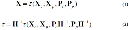
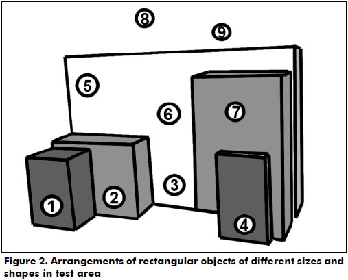
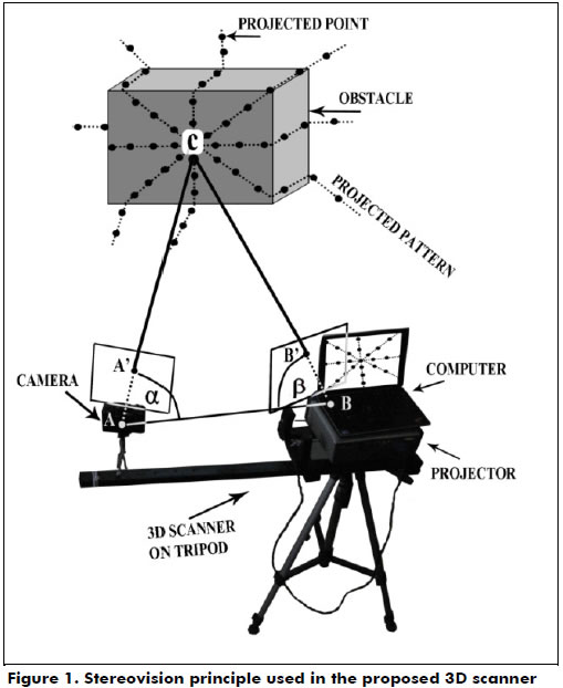
<body><![CDATA[<p>  <b>3D Scanner System</b></p>     <p>  In this paper, a simple and low-cost laser range finder with 3D  scanning capabilities is proposed. The system should enable mobile robots to  detect obstacles in their vicinity and, when required, to obtain detailed  surface scans of a single object to analyze various properties such as shape  and size. A detailed surface scan might be required in situations where a robot  has to distinguish between humans or other living objects in its workspace to  avoid collisions and to predict its trajectory.</p>     <p>  The adaptability of the proposed scanner system is achieved by  allowing the scanner to project multiple patterns at the target area. A longer  scanning time with more than one projected pattern enables a more detailed  scan, which enables limited object recognition, while short scanning times (a  single pattern is projected) allows the scanner to detect obstacles without any  detail analysis. A more detailed description of the adaptability of the system  is contained in the following subsections.</p>      <p><b>Materials and methods</b></p>     <p>  The proposed concept of an adaptive scanner finder was tested in a  laboratory with an off-the shelf DLP (Digital Light Processing) projector as a  main component (<a href="#f1">Figure 1</a>). The DLP projector projects light patterns as would a  laser projector. The DLP projector paired with a compact digital camera creates  a simple stereovision system (Rocchini, 2001), where the projector is the  active component and the camera is the passive one. The same stereovision  principle is implemented in human vision to detect a range map of the  surrounding world (Hartley, 2003). The video projector used was an Optoma EP739  DLP, projecting video at a resolution of 1024 x 768 pixels at a frame rate of  60 Hz, while the Cannon G9 digital camera was recording at a resolution of 640  x 480 pixels at a frame rate 60 Hz. The described components are to be used in  proof-of-concept tests, while the completed system would include a laser light  source instead of a projector and a high-speed camera, enabling scans to be  executed in a matter of a few milliseconds. </p>     <p><i>Stereovision system and  calibration:</i> If a single light ray is projected  from a projector (denoted as <b>B</b> in  <a href="#f1">Figure 1</a>), it passes through the projector frame (denoted as point <b>B'</b>), and it hits the target at point <b>C</b>. The reflected light ray is captured  by the camera at its plane (denoted as point <b>A'</b>). The pixel on the camera plane (<b>A'</b>) and the pixel on the projector plane (<b>B'</b>) correspond to an angle between the camera and object (<b>&alpha;</b>) and an angle between the projector and object (<b>&beta;</b>). If the exact position of the camera and projector in the world  coordinate frame is known, the problem of reconstructing the exact position of  point <b>C</b> is reduced to a simple  triangulation problem. </p>     <p>    <center><a name="f1"></a><img src="/img/revistas/iei/v34n3/v34n3a07f1.jpg"></center></p>     <p>Calibration is a mandatory requirement of any multi-camera vision  system (Heikkila, 1997; Tsai, 1987; Zhang, 1999; Zollner, 2004). It is used for  the calculation of the relations between cameras and scenes, thus enabling the  simple reconstruction of objects if their locations on the camera and projector  planes are known (<b>A'</b> and <b>B'</b>). The measurement procedure is  initiated with a calibration step, which is performed once when the camera and  projector are placed at the desired locations with respect to each other. The  outputs of the calibration process are the camera and projector matrices <b>P<sub>c</sub></b> and <b>P<sub>p</sub></b>, respectively, which contain orientation and position  information in the coordinate frame defined by the calibration object. An  extrinsic part of the calibration procedure requires the scanning of a scene  with a well-known configuration (covering most of the system's field of view).  Given a set of corresponding pixel pairs, system calibration is achieved using  an approach proposed by Heikkila (Heikkila, 1997). To achieve better  calibration results and to minimize possible errors due to manual key point  selection, a certain level of redundancy was built into the calibration process  through the use of nine calibration points, denoted as 1-9 (<a href="#f2">Figure 2</a>), with  five objects present in the scene. The intrinsic part of the calibration was  not performed because lens distortion from both the projector and camera were  found to be minimal. Using a Direct Linear Transformation (DLT), the  coordinates for each point on the scanned surface are calculated (Abdel-Aziz,  1971). The position of point <b>X</b> in  the reference coordinate frame is derived using equations (1) and (2), where <b>X</b>c and <b>X</b>p are its coordinates in the camera and projector  planes, respectively; <b>Pc </b>and <b>Pp</b> are the camera and  projector matrices, respectively; &tau; is a triangulation function;  and <b>H</b> is the linear transformation  that transforms <b>X</b><sub>c</sub> = <b>HX</b><sub>p</sub> (Hartley, 2003).</p>     <p>    ]]></body>
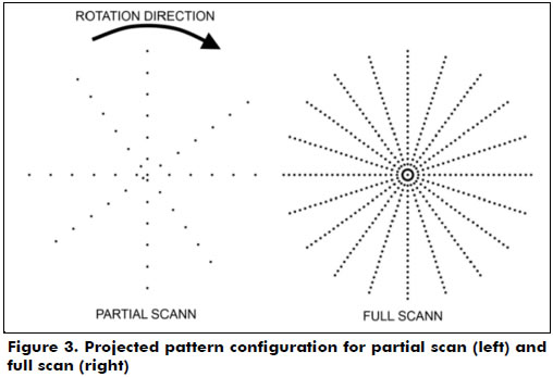
<body><![CDATA[<center><img src="/img/revistas/iei/v34n3/v34n3a07e1y2.jpg"></center></p>     <p>    <center><a name="f2"></a><img src="/img/revistas/iei/v34n3/v34n3a07f2.jpg"></center></p>     <p>Projected  patterns: The projection must contain as many  points as possible but be arranged in such a way that any point from the  pattern can be uniquely identified during a scan. Instead of projecting a  single point onto the target area, the proposed system projects a pattern  containing 49 points in a star configuration. The proposed configuration  consists of 6 star segments (arms) with 8 points and one central point (49  points in total). A total of 8 points per segment was selected considering the  camera's resolution (480 vertical lines), allowing at least 2 pixels of  vertical distance between projected points in the full scan pattern. A higher  number of points in the star segment would not dramatically increase the  system's detection accuracy, while a lower number of points would decrease the  scanner's total resolution. A total of six star segments was the maximum number  of segments that would not project neighboring points too close to each other.  A more advanced camera (in terms of resolution) would allow for a larger number  of points in the star configuration. Several other pattern configurations were  tested but with less promising results in terms of the trade-off between the  algorithm's complexity (point recognition and racking) and the area coverage.  Thus, the proposed configuration was considered to be optimal in that sense. By  projecting multiple points at the target area, the system is able to scan the  desired area in a single frame (if the camera and projector are synchronized).  By aligning points in the form of dotted lines, identifying each point from the  camera image is made easier. A simple prediction algorithm based on pattern  dynamics is implemented and predicts the location of a point in the next  scanning frame, thus minimizing errors when points overlap or are not visible  in some frames.</p>      <p>In a single projected pattern (<a href="#f3">Figure 3</a>, left), points are arranged  (the sides of the dotted lines are shifted) in such a way that when the matrix  rotates, the points do not overlap previous projections. One full scan cycle  (<a href="#f3">Figure 3</a>, right) consists of several single projected patterns. The center of  a projected pattern is fitted with more points, resulting in a higher  resolution scan at the center and a lower resolution scan at the projection  edges. The final result of the 3D structured light scanning process is a "point  cloud" that represents a scanned surface.</p>     <p>    <center><a name="f3"></a><img src="/img/revistas/iei/v34n3/v34n3a07f3.jpg"></center></p>     <p>  <font size="3"><b>Experimental Measurement</b></font></p>     <p>  The system was tested in two scenarios, both of which could occur  during normal operation. A set of five rectangular objects with known  dimensions are arranged similar to what is shown in <a href="#f2">Figure 2</a>. A set of nine  small markers is placed in the scene and are denoted as 1-9 in <a href="#f2">Figure 2</a>. The  locations of the markers were measured with a precision caliper (0.2 mm) and  are used in the calibration process. The object dimensions were also measured  with a caliper, which was used in later accuracy trials. The minimum allowed  distance of objects from the experimental scanner was 20 cm, while the maximum  distance was constrained by the light intensity of the projected patterns (up  to 5 m under our laboratory conditions). In the experiments, the measurements  were performed with a scanner at a distance of 150 cm from the scanned objects.</p>     <p>  After calibration, a partial scan was executed (with only one  projected frame), after which a full scan was executed (full cycle of 10  projected frames). Each projected and detected point was paired, from which a  point cloud was derived. Using a simple image interpolation method (2D  interpolation) and data from each point, a simple depth map was constructed.  The projector and camera were set to operate at 60 Hz. Because they were not  synchronized, the resulting scanner frame rate was lowered to 30 Hz. Because a  full scan cycle contains 10 frames, a cycle is completed in 330 ms (33 ms per  projected frame).</p>     ]]></body>
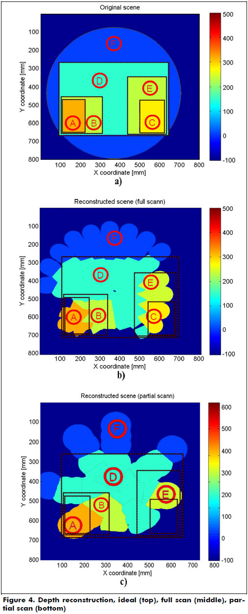
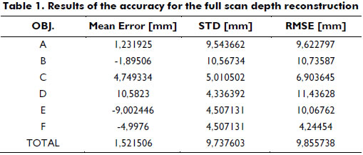
<body><![CDATA[<p>  <font size="3"><b>Results and Discussion</b></font></p>     <p>  The results are derived from the reconstructed depth map obtained in  the previous step, where partial and full scan cycles were independently  analyzed. The depth map of the original scene (object formation from <a href="#f2">Figure 2</a>)  is shown in <a href="#f4">Figure 4a</a>. The letter tags A-F mark a single object on the scene,  while the circle shows the area covered by the projected patterns. All the  calculations and the graphical presentation were performed using Matlab 2010.  The resulting depth map of one full scan cycle is shown in Figure 4b, which  contains all objects from the original scene in terms of sizes and shapes that  resemble the object in the original configuration. Using only the depth map  from <a href="#f4">Figure 4b</a>, simple calculations of the objects' sizes and types could be  performed. </p>     <p>    <center><a name="f4"></a><img src="/img/revistas/iei/v34n3/v34n3a07f4.jpg"></center></p>     <p>  The depth map reconstructed from a partial scan is shown in <a href="#f4">Figure  4c</a>. Nearby objects are detected, and the distance from them is calculated, but  no other useful information about the object shape and size can be extracted  from the depth map. When the partial scan is performed, it is possible that  some smaller objects are not detected by the scanner in the current frame. As  shown in <a href="#f4">Figure 4c</a>, object <b>C</b> is not  detected, which is because the object is not covered with the pattern in the  current projection frame. The rotation of the projected pattern in the next  frames enables the detection of a previously undetected object. The  introduction of a high-speed camera (and laser projector) enables shorter  scanning times (less than 33 ms per frame), which minimizes the possibility of  an obstacle not being detected during navigation.</p>     <p>  When increasing the number of points in the projected pattern (full  scan), the resulting depth map is more similar to the ideal depth map (<a href="#f4">Figure 4a</a>), and some limited analyses of the objects' characteristics are feasible.  <a href="#t1">Table 1</a> shows the results of the depth  reconstruction for the full scan cycle for all five objects, denoted  as objects <b>A</b>,<b> B</b>,<b> C</b>,<b> D</b>,<b> E</b>, and the reference background, denoted as <b>F</b>. The last row (<a href="#t1">Table 1</a>) shows the results for all objects (all  points detected on objects). One can conclude that the system's depth  reconstruction performs with a mean error of 1.5 mm and an RMSE better than 1  cm, which is more than adequate for its intended application.</p>     <p>    <center><a name="t1"></a><img src="/img/revistas/iei/v34n3/v34n3a07t1.jpg"></center></p>     <p>The accuracy of the proposed system could be improved by  implementing a sub-pixel point center detection algorithm (Ling, 2005; Stancic,  Grujic, 2013), while including more points in the projected pattern would  increase the system's final resolution. To summarize, the only difference  between the partial and full scans is the number of points projected onto the  area, and thus, the resolution of the scan is different.</p>     <p>  <b>Future developments</b></p>     ]]></body>
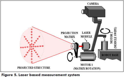
<body><![CDATA[<p>  The final system should use a laser projector and a high-speed  camera (<a href="#f5">Figure 5</a>). A single source laser beam would pass through a matrix that  scatters light in a desired configuration. Motor 1 would rotate the laser  matrix with a controlled speed, thus controlling the system's scanning speed. A  slower rotation means a higher resolution scan at the cost of longer scanning  times. This scan setting is useful for the recognition of objects.  Increasing the matrix rotation speed results  in a lower resolution scan, which can be completed quickly. An evident drawback  of this scan setting is the inability to recognize and analyze the object's  properties. A small alteration of the scanner's field of view can be achieved  by modifying the laser based on the matrix's distance, thus enabling an even  higher density of projected points at the desired area. Finally, by increasing  the rotation speed with the largest FOV (field of view), a mobile robot can  only obtain information about the obstacles present in its vicinity, even if  the robot is on the move. By pointing the scanner module at a single target and  by reducing the scanning speed (Motor 1 rotation speed), a scanned object could  be detected with more points, thus enabling object recognition and analysis.</p>     <p>    <center><a name="f5"></a><img src="/img/revistas/iei/v34n3/v34n3a07f5.jpg"></center></p>     <p>The scanner module is intended to be placed on a rotating platform,  which enables the scanner to horizontally scan the area. The algorithm for  scene reconstruction has to be modified in a way that considers the rotation of  the scanner module relative to the robot's main body and the displacement of  the robot using odometry or a similar technique. As shown in (Stancic, Music,  2013), vibrations slightly affect a scanner's accuracy, but this can be  partially compensated for by introducing an accelerometer in the scanner  module. This improvement is planned as a component of robotic aids for blind  and low-vision persons.</p>     <p>  <font size="3"><b>Conclusions</b></font></p>     <p>  Information about the exact position of a robot in a coordinate  system and sensing obstacles in its vicinity is a fundamental requirement for  successful mobile robot navigation. To this end, modern mobile robots relay  information obtained from multiple sensors or are guided by an operator.  Physically small or low-cost robots do not contain advanced scanning sensors or  vision systems. Therefore, a novel concept for a low-cost, adaptive 3D scanner  and range finder was proposed in this paper. The scanner is capable of working  in two modes: fast scanning, which is used for detecting nearby obstacles and  measuring distances to obstacles, and slow scanning, which is useful when a  more detailed scan of a single object is required. When a high-resolution scan  of static objects is needed, the robot may be required to stop, while working  in obstacle detection mode, the system compensates for the robot's motion. The  accuracy of both modes is similar, and longer scan times only provide higher  resolution and consequently the capability of limited object analyses. A  partial scan covers an area with 49 points, while a full scan covers the  scanned area with up to 490 points. The mean error for the depth map  reconstruction was 1.52 mm, with an RMSE below 1 cm, which is more than  adequate for its intended application. The inclusion of a laser projector  instead of a DLP projector and a high-speed camera instead of a compact digital  camera would greatly increase the system's operating speed.</p> <hr>     <p><font size="3"><b>References</b></font> </p>     <!-- ref --><p>Abdel-Aziz,  Y. I., &amp; Karara, H. M. (1971). <i>Direct linear transformation from comparator coordinates into object  space coordinates in close-range photogrammetry</i>.  Paper presented at Symposium on Close-Range Photogrammetry, Urbana-Champaign  campus, American Society of Photogrammetry.    &nbsp;&nbsp;&nbsp;&nbsp;&nbsp;&nbsp;&nbsp;&nbsp;[&#160;<a href="javascript:void(0);" onclick="javascript: window.open('/scielo.php?script=sci_nlinks&ref=000070&pid=S0120-5609201400030000700001&lng=','','width=640,height=500,resizable=yes,scrollbars=1,menubar=yes,');">Links</a>&#160;]<!-- end-ref --></p>     <!-- ref --><p>  Abu Dalhoum, A. L., Al-Rawi, M., Al -Sharieh,  A., Najjar, A. M., Najjar, M. M., &amp; Shayreh, S. (2008).  Remotely Controller Intelligent Vehicle to  Handle Public Places Security. <i>WSEAS  Transactions on Systems</i>, <i>7</i>(10),  1058-1069.    &nbsp;&nbsp;&nbsp;&nbsp;&nbsp;&nbsp;&nbsp;&nbsp;[&#160;<a href="javascript:void(0);" onclick="javascript: window.open('/scielo.php?script=sci_nlinks&ref=000072&pid=S0120-5609201400030000700002&lng=','','width=640,height=500,resizable=yes,scrollbars=1,menubar=yes,');">Links</a>&#160;]<!-- end-ref --></p>     <!-- ref --><p>  Aufrere, R., Mertz, C., &amp; Thorpe, C.  (2003). Multiple sensor fusion for detecting location of curbs, walls, and  barriers. Paper presented at Intelligent Vehicles Symposium, Columbus, IEEE.    &nbsp;&nbsp;&nbsp;&nbsp;&nbsp;&nbsp;&nbsp;&nbsp;[&#160;<a href="javascript:void(0);" onclick="javascript: window.open('/scielo.php?script=sci_nlinks&ref=000074&pid=S0120-5609201400030000700003&lng=','','width=640,height=500,resizable=yes,scrollbars=1,menubar=yes,');">Links</a>&#160;]<!-- end-ref --></p>     <!-- ref --><p>  Borenstein, J., Everett, H. R., Feng, L., &amp;  Wehe, D. (1997). Mobile Robot Positioning Sensors and Techniques. <i>Journal of Robotic Systems</i>, <i>14</i>(4), 231-249.    &nbsp;&nbsp;&nbsp;&nbsp;&nbsp;&nbsp;&nbsp;&nbsp;[&#160;<a href="javascript:void(0);" onclick="javascript: window.open('/scielo.php?script=sci_nlinks&ref=000076&pid=S0120-5609201400030000700004&lng=','','width=640,height=500,resizable=yes,scrollbars=1,menubar=yes,');">Links</a>&#160;]<!-- end-ref --></p>     <!-- ref --><p>  Cang Y., &amp; Borenstein, J. (2002, May). <i>Characterization of a 2-D Laser Scanner for  Mobile Robot Obstacle Negotiation</i>. Paper presented at International  Conference on Robotics and Automation, Washington D. C., IEEE.    &nbsp;&nbsp;&nbsp;&nbsp;&nbsp;&nbsp;&nbsp;&nbsp;[&#160;<a href="javascript:void(0);" onclick="javascript: window.open('/scielo.php?script=sci_nlinks&ref=000078&pid=S0120-5609201400030000700005&lng=','','width=640,height=500,resizable=yes,scrollbars=1,menubar=yes,');">Links</a>&#160;]<!-- end-ref --></p>     <!-- ref --><p>  Correra, D. S. O., Scotti, D. F., Prado, M. G.,  &amp; Sales, D. F. (2012). <i>Mobile Robots  Navigation in Indoor Environments Using Kinect Sensor</i>. Paper presented at Brazilian  Conference on Critical Embedded Systems, Sao Paulo, IEEE.    &nbsp;&nbsp;&nbsp;&nbsp;&nbsp;&nbsp;&nbsp;&nbsp;[&#160;<a href="javascript:void(0);" onclick="javascript: window.open('/scielo.php?script=sci_nlinks&ref=000080&pid=S0120-5609201400030000700006&lng=','','width=640,height=500,resizable=yes,scrollbars=1,menubar=yes,');">Links</a>&#160;]<!-- end-ref --></p>     <!-- ref --><p>  Darms, M. S., Rybski, P., Baker, C., &amp; Urmson,  C. (2009). Obstacle detection and tracking for the urban challenge. <i>Intelligent Transportation Systems</i>, <i>10</i>(3), 475-485.    &nbsp;&nbsp;&nbsp;&nbsp;&nbsp;&nbsp;&nbsp;&nbsp;[&#160;<a href="javascript:void(0);" onclick="javascript: window.open('/scielo.php?script=sci_nlinks&ref=000082&pid=S0120-5609201400030000700007&lng=','','width=640,height=500,resizable=yes,scrollbars=1,menubar=yes,');">Links</a>&#160;]<!-- end-ref --></p>     <!-- ref --><p>  Fayad, F., &amp; Cherfaoui, V. (2007). <i>Tracking objects using a laser scanner in  driving situation based on modeling target shape</i>. Paper presented at  Intelligent Vehicles Symposium, Istanbul, IEEE.    &nbsp;&nbsp;&nbsp;&nbsp;&nbsp;&nbsp;&nbsp;&nbsp;[&#160;<a href="javascript:void(0);" onclick="javascript: window.open('/scielo.php?script=sci_nlinks&ref=000084&pid=S0120-5609201400030000700008&lng=','','width=640,height=500,resizable=yes,scrollbars=1,menubar=yes,');">Links</a>&#160;]<!-- end-ref --></p>     <!-- ref --><p>  Fotiadis, E. P., Garz&oacute;n, M., &amp; Barrientos,  A. (2013). Human Detection from a Mobile Robot Using Fusion of Laser and Vision  Information. <i>Sensors</i>, <i>13</i>(9), 11603-11635.    &nbsp;&nbsp;&nbsp;&nbsp;&nbsp;&nbsp;&nbsp;&nbsp;[&#160;<a href="javascript:void(0);" onclick="javascript: window.open('/scielo.php?script=sci_nlinks&ref=000086&pid=S0120-5609201400030000700009&lng=','','width=640,height=500,resizable=yes,scrollbars=1,menubar=yes,');">Links</a>&#160;]<!-- end-ref --></p>     <!-- ref --><p>  Fisher, A. (2014). <i>Inside Google's Quest to Popularize Self-Driving Cars</i>. Popular  Science. Retrieved from <a href="http://www.popsci.com/cars/article/2013-09/google-self-driving-car" target="_blank">http://www.popsci.com/cars/article/2013-09/google-self-driving-car</a>&nbsp;&nbsp;&nbsp;&nbsp;&nbsp;&nbsp;&nbsp;&nbsp;[&#160;<a href="javascript:void(0);" onclick="javascript: window.open('/scielo.php?script=sci_nlinks&ref=000088&pid=S0120-5609201400030000700010&lng=','','width=640,height=500,resizable=yes,scrollbars=1,menubar=yes,');">Links</a>&#160;]<!-- end-ref --><!-- ref --><p>  Fuerstenberg, K. C. (2005). <i>Pedestrian protection using laser scanners</i>.  Paper presented at Intelligent Transportation Systems Conference, Vienna, IEEE.    &nbsp;&nbsp;&nbsp;&nbsp;&nbsp;&nbsp;&nbsp;&nbsp;[&#160;<a href="javascript:void(0);" onclick="javascript: window.open('/scielo.php?script=sci_nlinks&ref=000089&pid=S0120-5609201400030000700011&lng=','','width=640,height=500,resizable=yes,scrollbars=1,menubar=yes,');">Links</a>&#160;]<!-- end-ref --></p>     <!-- ref --><p>  Gandhi, T., &amp; Trivedi, M. M. (2007).  Pedestrian protection systems: Issues, survey, and challenges. <i>Intelligent Transportation Systems</i>, <i>8</i>(3), 413-430.    &nbsp;&nbsp;&nbsp;&nbsp;&nbsp;&nbsp;&nbsp;&nbsp;[&#160;<a href="javascript:void(0);" onclick="javascript: window.open('/scielo.php?script=sci_nlinks&ref=000091&pid=S0120-5609201400030000700012&lng=','','width=640,height=500,resizable=yes,scrollbars=1,menubar=yes,');">Links</a>&#160;]<!-- end-ref --></p>     ]]></body>
<body><![CDATA[<!-- ref --><p>  Hartley, R., &amp; Zisserman, A. (2004). <i>Multiple View Geometry in Computer Vision</i>.  Cambridge, UK: Cambridge University Press.    &nbsp;&nbsp;&nbsp;&nbsp;&nbsp;&nbsp;&nbsp;&nbsp;[&#160;<a href="javascript:void(0);" onclick="javascript: window.open('/scielo.php?script=sci_nlinks&ref=000093&pid=S0120-5609201400030000700013&lng=','','width=640,height=500,resizable=yes,scrollbars=1,menubar=yes,');">Links</a>&#160;]<!-- end-ref --></p>     <!-- ref --><p>  Heikkila, J., &amp; Silven, O. (1997). <i>A Four-step Camera Calibration Procedure with  Implicit Image Correction</i>. Paper presented at Conference on Computer Vision  and Pattern Recognition, San Juan, IEEE Computer Society.    &nbsp;&nbsp;&nbsp;&nbsp;&nbsp;&nbsp;&nbsp;&nbsp;[&#160;<a href="javascript:void(0);" onclick="javascript: window.open('/scielo.php?script=sci_nlinks&ref=000095&pid=S0120-5609201400030000700014&lng=','','width=640,height=500,resizable=yes,scrollbars=1,menubar=yes,');">Links</a>&#160;]<!-- end-ref --></p>     <!-- ref --><p>  Huang, A. S., Antone, M., Olson, E., Moore, D.,  Fletcher, L., Teller, S., &amp; Leonard, J. (2010). A high-rate, heterogeneous  data set from the DARPA Urban Challenge. <i>International  Journal of Robotics Research</i>, <i>29</i>(13),  1595-1601.    &nbsp;&nbsp;&nbsp;&nbsp;&nbsp;&nbsp;&nbsp;&nbsp;[&#160;<a href="javascript:void(0);" onclick="javascript: window.open('/scielo.php?script=sci_nlinks&ref=000097&pid=S0120-5609201400030000700015&lng=','','width=640,height=500,resizable=yes,scrollbars=1,menubar=yes,');">Links</a>&#160;]<!-- end-ref --></p>     <!-- ref --><p>  Kucsera, P. (2006). Sensors for mobile robot  systems. <i>Academic and Applied Research in  Military Science</i>, <i>5</i>(4), 645-658.    &nbsp;&nbsp;&nbsp;&nbsp;&nbsp;&nbsp;&nbsp;&nbsp;[&#160;<a href="javascript:void(0);" onclick="javascript: window.open('/scielo.php?script=sci_nlinks&ref=000099&pid=S0120-5609201400030000700016&lng=','','width=640,height=500,resizable=yes,scrollbars=1,menubar=yes,');">Links</a>&#160;]<!-- end-ref --></p>     <!-- ref --><p>  Kumari, C. L. (2012). Building Algorithm for  Obstacle Detection and Avoidance, System for Wheeled Mobile Robot. <i>Global Journal of Researches in  Engineering(F): Electrical and Electronics Engineering</i>, <i>12</i>(11).    &nbsp;&nbsp;&nbsp;&nbsp;&nbsp;&nbsp;&nbsp;&nbsp;[&#160;<a href="javascript:void(0);" onclick="javascript: window.open('/scielo.php?script=sci_nlinks&ref=000101&pid=S0120-5609201400030000700017&lng=','','width=640,height=500,resizable=yes,scrollbars=1,menubar=yes,');">Links</a>&#160;]<!-- end-ref --></p>     ]]></body>
<body><![CDATA[<!-- ref --><p>  Ling, D., Hsu, H. Y., Lin, G. C. I., &amp; Lee,  S. H. (2005). Enhanced image-based coordinate measurement using a  super-resolution method. <i>Robotics and  Computer-Integrated Manufacturing</i>, <i>21</i>(6),  579-588.    &nbsp;&nbsp;&nbsp;&nbsp;&nbsp;&nbsp;&nbsp;&nbsp;[&#160;<a href="javascript:void(0);" onclick="javascript: window.open('/scielo.php?script=sci_nlinks&ref=000103&pid=S0120-5609201400030000700018&lng=','','width=640,height=500,resizable=yes,scrollbars=1,menubar=yes,');">Links</a>&#160;]<!-- end-ref --></p>     <!-- ref --><p>  Liu, H-B., Dong, Y-J., Huangfu, C-H., &amp; Wang  F-Z. (2012). Obstacle detection algorithm for mobile robot based on  multi-sensor. Paper presented at Chinese Control Conference, Hefei, Chinese  Association of Automation.    &nbsp;&nbsp;&nbsp;&nbsp;&nbsp;&nbsp;&nbsp;&nbsp;[&#160;<a href="javascript:void(0);" onclick="javascript: window.open('/scielo.php?script=sci_nlinks&ref=000105&pid=S0120-5609201400030000700019&lng=','','width=640,height=500,resizable=yes,scrollbars=1,menubar=yes,');">Links</a>&#160;]<!-- end-ref --></p>     <!-- ref --><p>  Mertz, C., Navarro-Serment, L. E., MacLachlan,  R., Rybski, P., Steinfeld, A., Suppe, A., Urmson, C., Vandapel, N., Hebert, M.,  &amp; Thorpe, C. (2013).  Moving Object  Detection with Laser Scanners. <i>Journal of  Field Robotics</i>, <i>30</i>(1), 17-43.    &nbsp;&nbsp;&nbsp;&nbsp;&nbsp;&nbsp;&nbsp;&nbsp;[&#160;<a href="javascript:void(0);" onclick="javascript: window.open('/scielo.php?script=sci_nlinks&ref=000107&pid=S0120-5609201400030000700020&lng=','','width=640,height=500,resizable=yes,scrollbars=1,menubar=yes,');">Links</a>&#160;]<!-- end-ref --></p>     <!-- ref --><p>  Navarro-Serment, L. E., Mertz, C., Vandapel,  N., &amp; Hebert, M. (2008). LADAR-based Pedestrian Detection and  Tracking. Paper presented at Workshop on Human Detection from Mobile Robot  Platforms within International Conference on Robotics and Automation, Pasadena,  IEEE.    &nbsp;&nbsp;&nbsp;&nbsp;&nbsp;&nbsp;&nbsp;&nbsp;[&#160;<a href="javascript:void(0);" onclick="javascript: window.open('/scielo.php?script=sci_nlinks&ref=000109&pid=S0120-5609201400030000700021&lng=','','width=640,height=500,resizable=yes,scrollbars=1,menubar=yes,');">Links</a>&#160;]<!-- end-ref --></p>     <!-- ref --><p>  Perrollaz, M., Labayrade, R., Royere, C.,  Hautiere, N., &amp; Aubert, D. (2006). Long range obstacle detection using  laser scanner and stereovision. Paper presented at Intelligent Vehicles  Symposium, Tokyo, IEEE.    &nbsp;&nbsp;&nbsp;&nbsp;&nbsp;&nbsp;&nbsp;&nbsp;[&#160;<a href="javascript:void(0);" onclick="javascript: window.open('/scielo.php?script=sci_nlinks&ref=000111&pid=S0120-5609201400030000700022&lng=','','width=640,height=500,resizable=yes,scrollbars=1,menubar=yes,');">Links</a>&#160;]<!-- end-ref --></p>     ]]></body>
<body><![CDATA[<!-- ref --><p>  Premebida, C., Ludwig, O., &amp; Nunes, U.  (2009). LIDAR and Vision-Based Pedestrian Detection System. <i>Journal of Field Robotics</i>, <i>26</i>(9), 696-711.    &nbsp;&nbsp;&nbsp;&nbsp;&nbsp;&nbsp;&nbsp;&nbsp;[&#160;<a href="javascript:void(0);" onclick="javascript: window.open('/scielo.php?script=sci_nlinks&ref=000113&pid=S0120-5609201400030000700023&lng=','','width=640,height=500,resizable=yes,scrollbars=1,menubar=yes,');">Links</a>&#160;]<!-- end-ref --></p>     <!-- ref --><p>  Rocchini, C., Cignoni, P., Montani, C., Pingi,  P., &amp; Scopigno, R. (2001). A low cost 3D scanner based on structured light. <i>Computer Graphics Forum</i>, <i>20</i>(3), 299-308.    &nbsp;&nbsp;&nbsp;&nbsp;&nbsp;&nbsp;&nbsp;&nbsp;[&#160;<a href="javascript:void(0);" onclick="javascript: window.open('/scielo.php?script=sci_nlinks&ref=000115&pid=S0120-5609201400030000700024&lng=','','width=640,height=500,resizable=yes,scrollbars=1,menubar=yes,');">Links</a>&#160;]<!-- end-ref --></p>     <!-- ref --><p>  Shapiro, G., &amp; Stockman, G. C. (2001). <i>Computer vision</i>. Upper Saddle River, NJ,  USA: Prentice-Hall.    &nbsp;&nbsp;&nbsp;&nbsp;&nbsp;&nbsp;&nbsp;&nbsp;[&#160;<a href="javascript:void(0);" onclick="javascript: window.open('/scielo.php?script=sci_nlinks&ref=000117&pid=S0120-5609201400030000700025&lng=','','width=640,height=500,resizable=yes,scrollbars=1,menubar=yes,');">Links</a>&#160;]<!-- end-ref --></p>     <!-- ref --><p>  Stancic, I., Grujic, T., &amp; Panjkota, A.  (2013). Design, Development, and Evaluation of Optical  Motion-Tracking System Based on Active White Light Markers. <i>IET Science, Measurement &amp; Tech-nology</i>, <i>7</i>(4), 206-214.    &nbsp;&nbsp;&nbsp;&nbsp;&nbsp;&nbsp;&nbsp;&nbsp;[&#160;<a href="javascript:void(0);" onclick="javascript: window.open('/scielo.php?script=sci_nlinks&ref=000119&pid=S0120-5609201400030000700026&lng=','','width=640,height=500,resizable=yes,scrollbars=1,menubar=yes,');">Links</a>&#160;]<!-- end-ref --></p>     <!-- ref --><p>  Stanèiæ, I., Musiæ, J., &amp; Zanchi, V.  (2013). Improved structured light 3D scanner with application to anthropometric  parameter estimation. <i>Measurement</i>, <i>46</i>(1), 716-726.    &nbsp;&nbsp;&nbsp;&nbsp;&nbsp;&nbsp;&nbsp;&nbsp;[&#160;<a href="javascript:void(0);" onclick="javascript: window.open('/scielo.php?script=sci_nlinks&ref=000121&pid=S0120-5609201400030000700027&lng=','','width=640,height=500,resizable=yes,scrollbars=1,menubar=yes,');">Links</a>&#160;]<!-- end-ref --></p>     ]]></body>
<body><![CDATA[<!-- ref --><p>  Sungbok, K., &amp; Hyun, B. K. (2010). High  Resolution Mobile Robot Obstacle Detection Using Low Directivity Ultrasonic  Sensor Ring. <i>Lecture Notes in Computer  Science</i>, <i>6216</i>, 426-433.    &nbsp;&nbsp;&nbsp;&nbsp;&nbsp;&nbsp;&nbsp;&nbsp;[&#160;<a href="javascript:void(0);" onclick="javascript: window.open('/scielo.php?script=sci_nlinks&ref=000123&pid=S0120-5609201400030000700028&lng=','','width=640,height=500,resizable=yes,scrollbars=1,menubar=yes,');">Links</a>&#160;]<!-- end-ref --></p>     <!-- ref --><p>  Tsai, R. Y. (1987). A versatile camera  calibration technique for high accuracy 3D machine vision metrology using  off-the-shelf TV cameras and lenses. <i>IEEE  Journal of Robotics and Automation</i>, <i>RA-3</i>(4),  323-344.    &nbsp;&nbsp;&nbsp;&nbsp;&nbsp;&nbsp;&nbsp;&nbsp;[&#160;<a href="javascript:void(0);" onclick="javascript: window.open('/scielo.php?script=sci_nlinks&ref=000125&pid=S0120-5609201400030000700029&lng=','','width=640,height=500,resizable=yes,scrollbars=1,menubar=yes,');">Links</a>&#160;]<!-- end-ref --></p>     <!-- ref --><p>  Zhang, Z. (1999). Flexible camera calibration  by viewing a plane from unknown orientations. Paper presented at International  Conference on Computer Vision, Kerkyra, IEEE.    &nbsp;&nbsp;&nbsp;&nbsp;&nbsp;&nbsp;&nbsp;&nbsp;[&#160;<a href="javascript:void(0);" onclick="javascript: window.open('/scielo.php?script=sci_nlinks&ref=000127&pid=S0120-5609201400030000700030&lng=','','width=640,height=500,resizable=yes,scrollbars=1,menubar=yes,');">Links</a>&#160;]<!-- end-ref --></p>     <!-- ref --><p>  Zollner, H., &amp; Sablatnig, R. (2004). <i>Comparison of methods for geometric camera  calibration using planar calibration targets</i>. Paper presented  at  Workshop   of the Austrian  Association  for  Pattern Recognition, Hagenberg, Austrian  Association for Pattern Recognition.    &nbsp;&nbsp;&nbsp;&nbsp;&nbsp;&nbsp;&nbsp;&nbsp;[&#160;<a href="javascript:void(0);" onclick="javascript: window.open('/scielo.php?script=sci_nlinks&ref=000129&pid=S0120-5609201400030000700031&lng=','','width=640,height=500,resizable=yes,scrollbars=1,menubar=yes,');">Links</a>&#160;]<!-- end-ref --></p>     <!-- ref --><p>  Zubair, M., &amp; Choudry, M. A. (2011). Land  Mine Detecting Robot Capable of Path Planning. <i>WSEAS Transactions on Systems and Control</i>, <i>6</i>(4), 105-114.    &nbsp;&nbsp;&nbsp;&nbsp;&nbsp;&nbsp;&nbsp;&nbsp;[&#160;<a href="javascript:void(0);" onclick="javascript: window.open('/scielo.php?script=sci_nlinks&ref=000131&pid=S0120-5609201400030000700032&lng=','','width=640,height=500,resizable=yes,scrollbars=1,menubar=yes,');">Links</a>&#160;]<!-- end-ref --></p> </font>     ]]></body>
<body><![CDATA[ ]]></body><back>
<ref-list>
<ref id="B1">
<nlm-citation citation-type="confpro">
<person-group person-group-type="author">
<name>
<surname><![CDATA[Abdel-Aziz]]></surname>
<given-names><![CDATA[Y. I]]></given-names>
</name>
<name>
<surname><![CDATA[Karara]]></surname>
<given-names><![CDATA[H. M]]></given-names>
</name>
</person-group>
<article-title xml:lang="en"><![CDATA[Direct linear transformation from comparator coordinates into object space coordinates in close-range photogrammetry]]></article-title>
<source><![CDATA[]]></source>
<year>1971</year>
<conf-name><![CDATA[ Symposium on Close-Range Photogrammetry]]></conf-name>
<conf-loc> </conf-loc>
</nlm-citation>
</ref>
<ref id="B2">
<nlm-citation citation-type="journal">
<person-group person-group-type="author">
<name>
<surname><![CDATA[Abu Dalhoum]]></surname>
<given-names><![CDATA[A. L]]></given-names>
</name>
<name>
<surname><![CDATA[Al-Rawi]]></surname>
<given-names><![CDATA[M]]></given-names>
</name>
<name>
<surname><![CDATA[Al -Sharieh]]></surname>
<given-names><![CDATA[A]]></given-names>
</name>
<name>
<surname><![CDATA[Najjar]]></surname>
<given-names><![CDATA[A. M]]></given-names>
</name>
<name>
<surname><![CDATA[Najjar]]></surname>
<given-names><![CDATA[M. M]]></given-names>
</name>
<name>
<surname><![CDATA[Shayreh]]></surname>
<given-names><![CDATA[S]]></given-names>
</name>
</person-group>
<article-title xml:lang="en"><![CDATA[Remotely Controller Intelligent Vehicle to Handle Public Places Security]]></article-title>
<source><![CDATA[WSEAS Transactions on Systems]]></source>
<year>2008</year>
<volume>7</volume>
<numero>10</numero>
<issue>10</issue>
<page-range>1058-1069</page-range></nlm-citation>
</ref>
<ref id="B3">
<nlm-citation citation-type="confpro">
<person-group person-group-type="author">
<name>
<surname><![CDATA[Aufrere]]></surname>
<given-names><![CDATA[R]]></given-names>
</name>
<name>
<surname><![CDATA[Mertz]]></surname>
<given-names><![CDATA[C]]></given-names>
</name>
<name>
<surname><![CDATA[Thorpe]]></surname>
<given-names><![CDATA[C]]></given-names>
</name>
</person-group>
<article-title xml:lang="en"><![CDATA[Multiple sensor fusion for detecting location of curbs, walls, and barriers]]></article-title>
<source><![CDATA[]]></source>
<year>2003</year>
<conf-name><![CDATA[ Intelligent Vehicles Symposium]]></conf-name>
<conf-loc>Columbus </conf-loc>
</nlm-citation>
</ref>
<ref id="B4">
<nlm-citation citation-type="journal">
<person-group person-group-type="author">
<name>
<surname><![CDATA[Borenstein]]></surname>
<given-names><![CDATA[J]]></given-names>
</name>
<name>
<surname><![CDATA[Everett]]></surname>
<given-names><![CDATA[H. R]]></given-names>
</name>
<name>
<surname><![CDATA[Feng]]></surname>
<given-names><![CDATA[L]]></given-names>
</name>
<name>
<surname><![CDATA[Wehe]]></surname>
<given-names><![CDATA[D]]></given-names>
</name>
</person-group>
<article-title xml:lang="en"><![CDATA[Mobile Robot Positioning Sensors and Techniques]]></article-title>
<source><![CDATA[Journal of Robotic Systems]]></source>
<year>1997</year>
<volume>14</volume>
<numero>4</numero>
<issue>4</issue>
<page-range>231-249</page-range></nlm-citation>
</ref>
<ref id="B5">
<nlm-citation citation-type="confpro">
<person-group person-group-type="author">
<name>
<surname><![CDATA[Cang]]></surname>
<given-names><![CDATA[Y]]></given-names>
</name>
<name>
<surname><![CDATA[Borenstein]]></surname>
<given-names><![CDATA[J]]></given-names>
</name>
</person-group>
<article-title xml:lang="en"><![CDATA[Characterization of a 2-D Laser Scanner for Mobile Robot Obstacle Negotiation]]></article-title>
<source><![CDATA[]]></source>
<year>2002</year>
<month>, </month>
<day>Ma</day>
<conf-name><![CDATA[ International Conference on Robotics and Automation]]></conf-name>
<conf-loc>Washington D. C. </conf-loc>
</nlm-citation>
</ref>
<ref id="B6">
<nlm-citation citation-type="confpro">
<person-group person-group-type="author">
<name>
<surname><![CDATA[Correra]]></surname>
<given-names><![CDATA[D. S. O]]></given-names>
</name>
<name>
<surname><![CDATA[Scotti]]></surname>
<given-names><![CDATA[D. F]]></given-names>
</name>
<name>
<surname><![CDATA[Prado]]></surname>
<given-names><![CDATA[M. G]]></given-names>
</name>
<name>
<surname><![CDATA[Sales]]></surname>
<given-names><![CDATA[D. F]]></given-names>
</name>
</person-group>
<article-title xml:lang="en"><![CDATA[Mobile Robots Navigation in Indoor Environments Using Kinect Sensor]]></article-title>
<source><![CDATA[]]></source>
<year>2012</year>
<conf-name><![CDATA[ Brazilian Conference on Critical Embedded Systems]]></conf-name>
<conf-loc>Sao Paulo </conf-loc>
</nlm-citation>
</ref>
<ref id="B7">
<nlm-citation citation-type="journal">
<person-group person-group-type="author">
<name>
<surname><![CDATA[Darms]]></surname>
<given-names><![CDATA[M. S]]></given-names>
</name>
<name>
<surname><![CDATA[Rybski]]></surname>
<given-names><![CDATA[P]]></given-names>
</name>
<name>
<surname><![CDATA[Baker]]></surname>
<given-names><![CDATA[C]]></given-names>
</name>
<name>
<surname><![CDATA[Urmson]]></surname>
<given-names><![CDATA[C]]></given-names>
</name>
</person-group>
<article-title xml:lang="en"><![CDATA[Obstacle detection and tracking for the urban challenge]]></article-title>
<source><![CDATA[Intelligent Transportation Systems]]></source>
<year>2009</year>
<volume>10</volume>
<numero>3</numero>
<issue>3</issue>
<page-range>475-485</page-range></nlm-citation>
</ref>
<ref id="B8">
<nlm-citation citation-type="confpro">
<person-group person-group-type="author">
<name>
<surname><![CDATA[Fayad]]></surname>
<given-names><![CDATA[F]]></given-names>
</name>
<name>
<surname><![CDATA[Cherfaoui]]></surname>
<given-names><![CDATA[V]]></given-names>
</name>
</person-group>
<article-title xml:lang="en"><![CDATA[Tracking objects using a laser scanner in driving situation based on modeling target shape]]></article-title>
<source><![CDATA[]]></source>
<year>2007</year>
<conf-name><![CDATA[ Intelligent Vehicles Symposium]]></conf-name>
<conf-loc> </conf-loc>
</nlm-citation>
</ref>
<ref id="B9">
<nlm-citation citation-type="journal">
<person-group person-group-type="author">
<name>
<surname><![CDATA[Fotiadis]]></surname>
<given-names><![CDATA[E. P]]></given-names>
</name>
<name>
<surname><![CDATA[Garzón]]></surname>
<given-names><![CDATA[M]]></given-names>
</name>
<name>
<surname><![CDATA[Barrientos]]></surname>
<given-names><![CDATA[A]]></given-names>
</name>
</person-group>
<article-title xml:lang="en"><![CDATA[Human Detection from a Mobile Robot Using Fusion of Laser and Vision Information]]></article-title>
<source><![CDATA[Sensors]]></source>
<year>2013</year>
<volume>13</volume>
<numero>9</numero>
<issue>9</issue>
<page-range>11603-11635</page-range></nlm-citation>
</ref>
<ref id="B10">
<nlm-citation citation-type="journal">
<person-group person-group-type="author">
<name>
<surname><![CDATA[Fisher]]></surname>
<given-names><![CDATA[A]]></given-names>
</name>
</person-group>
<article-title xml:lang="en"><![CDATA[Inside Google's Quest to Popularize Self-Driving Cars]]></article-title>
<source><![CDATA[Popular Science]]></source>
<year>2014</year>
</nlm-citation>
</ref>
<ref id="B11">
<nlm-citation citation-type="confpro">
<person-group person-group-type="author">
<name>
<surname><![CDATA[Fuerstenberg]]></surname>
<given-names><![CDATA[K. C]]></given-names>
</name>
</person-group>
<article-title xml:lang="en"><![CDATA[Pedestrian protection using laser scanners]]></article-title>
<source><![CDATA[]]></source>
<year>2005</year>
<conf-name><![CDATA[ Intelligent Transportation Systems Conference]]></conf-name>
<conf-loc>Vienna </conf-loc>
</nlm-citation>
</ref>
<ref id="B12">
<nlm-citation citation-type="journal">
<person-group person-group-type="author">
<name>
<surname><![CDATA[Gandhi]]></surname>
<given-names><![CDATA[T]]></given-names>
</name>
<name>
<surname><![CDATA[Trivedi]]></surname>
<given-names><![CDATA[M. M]]></given-names>
</name>
</person-group>
<article-title xml:lang="en"><![CDATA[Pedestrian protection systems: Issues, survey, and challenges]]></article-title>
<source><![CDATA[Intelligent Transportation Systems]]></source>
<year>2007</year>
<volume>8</volume>
<numero>3</numero>
<issue>3</issue>
<page-range>413-430</page-range></nlm-citation>
</ref>
<ref id="B13">
<nlm-citation citation-type="book">
<person-group person-group-type="author">
<name>
<surname><![CDATA[Hartley]]></surname>
<given-names><![CDATA[R]]></given-names>
</name>
<name>
<surname><![CDATA[Zisserman]]></surname>
<given-names><![CDATA[A]]></given-names>
</name>
</person-group>
<source><![CDATA[Multiple View Geometry in Computer Vision]]></source>
<year>2004</year>
<publisher-loc><![CDATA[Cambridge ]]></publisher-loc>
<publisher-name><![CDATA[Cambridge University Press]]></publisher-name>
</nlm-citation>
</ref>
<ref id="B14">
<nlm-citation citation-type="confpro">
<person-group person-group-type="author">
<name>
<surname><![CDATA[Heikkila]]></surname>
<given-names><![CDATA[J]]></given-names>
</name>
<name>
<surname><![CDATA[Silven]]></surname>
<given-names><![CDATA[O]]></given-names>
</name>
</person-group>
<article-title xml:lang="en"><![CDATA[A Four-step Camera Calibration Procedure with Implicit Image Correction]]></article-title>
<source><![CDATA[]]></source>
<year>1997</year>
<conf-name><![CDATA[ Conference on Computer Vision and Pattern Recognition]]></conf-name>
<conf-loc>San Juan </conf-loc>
</nlm-citation>
</ref>
<ref id="B15">
<nlm-citation citation-type="journal">
<person-group person-group-type="author">
<name>
<surname><![CDATA[Huang]]></surname>
<given-names><![CDATA[A. S]]></given-names>
</name>
<name>
<surname><![CDATA[Antone]]></surname>
<given-names><![CDATA[M]]></given-names>
</name>
<name>
<surname><![CDATA[Olson]]></surname>
<given-names><![CDATA[E]]></given-names>
</name>
<name>
<surname><![CDATA[Moore]]></surname>
<given-names><![CDATA[D]]></given-names>
</name>
<name>
<surname><![CDATA[Fletcher]]></surname>
<given-names><![CDATA[L]]></given-names>
</name>
<name>
<surname><![CDATA[Teller]]></surname>
<given-names><![CDATA[S]]></given-names>
</name>
<name>
<surname><![CDATA[Leonard]]></surname>
<given-names><![CDATA[J]]></given-names>
</name>
</person-group>
<article-title xml:lang="en"><![CDATA[A high-rate, heterogeneous data set from the DARPA Urban Challenge]]></article-title>
<source><![CDATA[International Journal of Robotics Research]]></source>
<year>2010</year>
<volume>29</volume>
<numero>13</numero>
<issue>13</issue>
<page-range>1595-1601</page-range></nlm-citation>
</ref>
<ref id="B16">
<nlm-citation citation-type="journal">
<person-group person-group-type="author">
<name>
<surname><![CDATA[Kucsera]]></surname>
<given-names><![CDATA[P]]></given-names>
</name>
</person-group>
<article-title xml:lang="en"><![CDATA[Sensors for mobile robot systems]]></article-title>
<source><![CDATA[Academic and Applied Research in Military Science]]></source>
<year>2006</year>
<volume>5</volume>
<numero>4</numero>
<issue>4</issue>
<page-range>645-658</page-range></nlm-citation>
</ref>
<ref id="B17">
<nlm-citation citation-type="journal">
<person-group person-group-type="author">
<name>
<surname><![CDATA[Kumari]]></surname>
<given-names><![CDATA[C. L]]></given-names>
</name>
</person-group>
<article-title xml:lang="en"><![CDATA[Building Algorithm for Obstacle Detection and Avoidance, System for Wheeled Mobile Robot]]></article-title>
<source><![CDATA[Global Journal of Researches in Engineering(F): Electrical and Electronics Engineering]]></source>
<year>2012</year>
<volume>12</volume>
<numero>11</numero>
<issue>11</issue>
</nlm-citation>
</ref>
<ref id="B18">
<nlm-citation citation-type="journal">
<person-group person-group-type="author">
<name>
<surname><![CDATA[Ling]]></surname>
<given-names><![CDATA[D]]></given-names>
</name>
<name>
<surname><![CDATA[Hsu]]></surname>
<given-names><![CDATA[H. Y]]></given-names>
</name>
<name>
<surname><![CDATA[Lin]]></surname>
<given-names><![CDATA[G. C. I]]></given-names>
</name>
<name>
<surname><![CDATA[Lee]]></surname>
<given-names><![CDATA[S. H]]></given-names>
</name>
</person-group>
<article-title xml:lang="en"><![CDATA[Enhanced image-based coordinate measurement using a super-resolution method]]></article-title>
<source><![CDATA[Robotics and Computer-Integrated Manufacturing]]></source>
<year>2005</year>
<volume>21</volume>
<numero>6</numero>
<issue>6</issue>
<page-range>579-588</page-range></nlm-citation>
</ref>
<ref id="B19">
<nlm-citation citation-type="confpro">
<person-group person-group-type="author">
<name>
<surname><![CDATA[Liu]]></surname>
<given-names><![CDATA[H-B]]></given-names>
</name>
<name>
<surname><![CDATA[Dong]]></surname>
<given-names><![CDATA[Y-J]]></given-names>
</name>
<name>
<surname><![CDATA[Huangfu]]></surname>
<given-names><![CDATA[C-H]]></given-names>
</name>
<name>
<surname><![CDATA[Wang]]></surname>
<given-names><![CDATA[F-Z]]></given-names>
</name>
</person-group>
<article-title xml:lang="en"><![CDATA[Obstacle detection algorithm for mobile robot based on multi-sensor]]></article-title>
<source><![CDATA[]]></source>
<year>2012</year>
<conf-name><![CDATA[ Chinese Control Conference]]></conf-name>
<conf-loc>Hefei </conf-loc>
</nlm-citation>
</ref>
<ref id="B20">
<nlm-citation citation-type="journal">
<person-group person-group-type="author">
<name>
<surname><![CDATA[Mertz]]></surname>
<given-names><![CDATA[C]]></given-names>
</name>
<name>
<surname><![CDATA[Navarro-Serment]]></surname>
<given-names><![CDATA[L. E]]></given-names>
</name>
<name>
<surname><![CDATA[MacLachlan]]></surname>
<given-names><![CDATA[R]]></given-names>
</name>
<name>
<surname><![CDATA[Rybski]]></surname>
<given-names><![CDATA[P]]></given-names>
</name>
<name>
<surname><![CDATA[Steinfeld]]></surname>
<given-names><![CDATA[A]]></given-names>
</name>
<name>
<surname><![CDATA[Suppe]]></surname>
<given-names><![CDATA[A]]></given-names>
</name>
<name>
<surname><![CDATA[Urmson]]></surname>
<given-names><![CDATA[C]]></given-names>
</name>
<name>
<surname><![CDATA[Vandapel]]></surname>
<given-names><![CDATA[N]]></given-names>
</name>
<name>
<surname><![CDATA[Hebert]]></surname>
<given-names><![CDATA[M]]></given-names>
</name>
<name>
<surname><![CDATA[Thorpe]]></surname>
<given-names><![CDATA[C]]></given-names>
</name>
</person-group>
<article-title xml:lang="en"><![CDATA[Moving Object Detection with Laser Scanners]]></article-title>
<source><![CDATA[Journal of Field Robotics]]></source>
<year>2013</year>
<volume>30</volume>
<numero>1</numero>
<issue>1</issue>
<page-range>17-43</page-range></nlm-citation>
</ref>
<ref id="B21">
<nlm-citation citation-type="confpro">
<person-group person-group-type="author">
<name>
<surname><![CDATA[Navarro-Serment]]></surname>
<given-names><![CDATA[L. E]]></given-names>
</name>
<name>
<surname><![CDATA[Mertz]]></surname>
<given-names><![CDATA[C]]></given-names>
</name>
<name>
<surname><![CDATA[Vandapel]]></surname>
<given-names><![CDATA[N]]></given-names>
</name>
<name>
<surname><![CDATA[Hebert]]></surname>
<given-names><![CDATA[M]]></given-names>
</name>
</person-group>
<article-title xml:lang="en"><![CDATA[LADAR-based Pedestrian Detection and Tracking]]></article-title>
<source><![CDATA[]]></source>
<year>2008</year>
<conf-name><![CDATA[ Workshop on Human Detection from Mobile Robot Platforms within International Conference on Robotics and Automation]]></conf-name>
<conf-loc>Pasadena </conf-loc>
</nlm-citation>
</ref>
<ref id="B22">
<nlm-citation citation-type="confpro">
<person-group person-group-type="author">
<name>
<surname><![CDATA[Perrollaz]]></surname>
<given-names><![CDATA[M]]></given-names>
</name>
<name>
<surname><![CDATA[Labayrade]]></surname>
<given-names><![CDATA[R]]></given-names>
</name>
<name>
<surname><![CDATA[Royere]]></surname>
<given-names><![CDATA[C]]></given-names>
</name>
<name>
<surname><![CDATA[Hautiere]]></surname>
<given-names><![CDATA[N]]></given-names>
</name>
<name>
<surname><![CDATA[Aubert]]></surname>
<given-names><![CDATA[D]]></given-names>
</name>
</person-group>
<article-title xml:lang="en"><![CDATA[Long range obstacle detection using laser scanner and stereovision]]></article-title>
<source><![CDATA[]]></source>
<year>2006</year>
<conf-name><![CDATA[ Intelligent Vehicles Symposium]]></conf-name>
<conf-loc>Tokyo </conf-loc>
</nlm-citation>
</ref>
<ref id="B23">
<nlm-citation citation-type="journal">
<person-group person-group-type="author">
<name>
<surname><![CDATA[Premebida]]></surname>
<given-names><![CDATA[C]]></given-names>
</name>
<name>
<surname><![CDATA[Ludwig]]></surname>
<given-names><![CDATA[O]]></given-names>
</name>
<name>
<surname><![CDATA[Nunes]]></surname>
<given-names><![CDATA[U]]></given-names>
</name>
</person-group>
<article-title xml:lang="en"><![CDATA[LIDAR and Vision-Based Pedestrian Detection System]]></article-title>
<source><![CDATA[Journal of Field Robotics]]></source>
<year>2009</year>
<volume>26</volume>
<numero>9</numero>
<issue>9</issue>
<page-range>696-711</page-range></nlm-citation>
</ref>
<ref id="B24">
<nlm-citation citation-type="journal">
<person-group person-group-type="author">
<name>
<surname><![CDATA[Rocchini]]></surname>
<given-names><![CDATA[C]]></given-names>
</name>
<name>
<surname><![CDATA[Cignoni]]></surname>
<given-names><![CDATA[P]]></given-names>
</name>
<name>
<surname><![CDATA[Montani]]></surname>
<given-names><![CDATA[C]]></given-names>
</name>
<name>
<surname><![CDATA[Pingi]]></surname>
<given-names><![CDATA[P]]></given-names>
</name>
<name>
<surname><![CDATA[Scopigno]]></surname>
<given-names><![CDATA[R]]></given-names>
</name>
</person-group>
<article-title xml:lang="en"><![CDATA[A low cost 3D scanner based on structured light]]></article-title>
<source><![CDATA[Computer Graphics Forum]]></source>
<year>2001</year>
<volume>20</volume>
<numero>3</numero>
<issue>3</issue>
<page-range>299-308</page-range></nlm-citation>
</ref>
<ref id="B25">
<nlm-citation citation-type="book">
<person-group person-group-type="author">
<name>
<surname><![CDATA[Shapiro]]></surname>
<given-names><![CDATA[G]]></given-names>
</name>
<name>
<surname><![CDATA[Stockman]]></surname>
<given-names><![CDATA[G. C]]></given-names>
</name>
</person-group>
<source><![CDATA[Computer vision]]></source>
<year>2001</year>
<publisher-loc><![CDATA[Upper Saddle River^eNJ NJ]]></publisher-loc>
<publisher-name><![CDATA[Prentice-Hall]]></publisher-name>
</nlm-citation>
</ref>
<ref id="B26">
<nlm-citation citation-type="journal">
<person-group person-group-type="author">
<name>
<surname><![CDATA[Stancic]]></surname>
<given-names><![CDATA[I]]></given-names>
</name>
<name>
<surname><![CDATA[Grujic]]></surname>
<given-names><![CDATA[T]]></given-names>
</name>
<name>
<surname><![CDATA[Panjkota]]></surname>
<given-names><![CDATA[A]]></given-names>
</name>
</person-group>
<article-title xml:lang="en"><![CDATA[Design, Development, and Evaluation of Optical Motion-Tracking System Based on Active White Light Markers]]></article-title>
<source><![CDATA[IET Science, Measurement & Technology]]></source>
<year>2013</year>
<volume>7</volume>
<numero>4</numero>
<issue>4</issue>
<page-range>206-214</page-range></nlm-citation>
</ref>
<ref id="B27">
<nlm-citation citation-type="journal">
<person-group person-group-type="author">
<name>
<surname><![CDATA[Stanèiæ]]></surname>
<given-names><![CDATA[I]]></given-names>
</name>
<name>
<surname><![CDATA[Musiæ]]></surname>
<given-names><![CDATA[J]]></given-names>
</name>
<name>
<surname><![CDATA[Zanchi]]></surname>
<given-names><![CDATA[V]]></given-names>
</name>
</person-group>
<article-title xml:lang="en"><![CDATA[Improved structured light 3D scanner with application to anthropometric parameter estimation]]></article-title>
<source><![CDATA[Measurement]]></source>
<year>2013</year>
<volume>46</volume>
<numero>1</numero>
<issue>1</issue>
<page-range>716-726</page-range></nlm-citation>
</ref>
<ref id="B28">
<nlm-citation citation-type="journal">
<person-group person-group-type="author">
<name>
<surname><![CDATA[Sungbok]]></surname>
<given-names><![CDATA[K]]></given-names>
</name>
<name>
<surname><![CDATA[Hyun]]></surname>
<given-names><![CDATA[B. K]]></given-names>
</name>
</person-group>
<article-title xml:lang="en"><![CDATA[High Resolution Mobile Robot Obstacle Detection Using Low Directivity Ultrasonic Sensor Ring]]></article-title>
<source><![CDATA[Lecture Notes in Computer Science]]></source>
<year>2010</year>
<volume>6216</volume>
<page-range>426-433</page-range></nlm-citation>
</ref>
<ref id="B29">
<nlm-citation citation-type="journal">
<person-group person-group-type="author">
<name>
<surname><![CDATA[Tsai]]></surname>
<given-names><![CDATA[R. Y]]></given-names>
</name>
</person-group>
<article-title xml:lang="en"><![CDATA[A versatile camera calibration technique for high accuracy 3D machine vision metrology using off-the-shelf TV cameras and lenses]]></article-title>
<source><![CDATA[IEEE Journal of Robotics and Automation]]></source>
<year>1987</year>
<volume>RA-3</volume>
<numero>4</numero>
<issue>4</issue>
<page-range>323-344</page-range></nlm-citation>
</ref>
<ref id="B30">
<nlm-citation citation-type="confpro">
<person-group person-group-type="author">
<name>
<surname><![CDATA[Zhang]]></surname>
<given-names><![CDATA[Z]]></given-names>
</name>
</person-group>
<article-title xml:lang="en"><![CDATA[Flexible camera calibration by viewing a plane from unknown orientations]]></article-title>
<source><![CDATA[]]></source>
<year>1999</year>
<conf-name><![CDATA[ International Conference on Computer Vision]]></conf-name>
<conf-loc>Kerkyra </conf-loc>
</nlm-citation>
</ref>
<ref id="B31">
<nlm-citation citation-type="confpro">
<person-group person-group-type="author">
<name>
<surname><![CDATA[Zollner]]></surname>
<given-names><![CDATA[H]]></given-names>
</name>
<name>
<surname><![CDATA[Sablatnig]]></surname>
<given-names><![CDATA[R]]></given-names>
</name>
</person-group>
<article-title xml:lang="en"><![CDATA[Comparison of methods for geometric camera calibration using planar calibration targets]]></article-title>
<source><![CDATA[]]></source>
<year>2004</year>
<conf-name><![CDATA[ Workshop of the Austrian Association for Pattern Recognition]]></conf-name>
<conf-loc>Hagenberg </conf-loc>
</nlm-citation>
</ref>
<ref id="B32">
<nlm-citation citation-type="journal">
<person-group person-group-type="author">
<name>
<surname><![CDATA[Zubair]]></surname>
<given-names><![CDATA[M]]></given-names>
</name>
<name>
<surname><![CDATA[Choudry]]></surname>
<given-names><![CDATA[M. A]]></given-names>
</name>
</person-group>
<article-title xml:lang="en"><![CDATA[Land Mine Detecting Robot Capable of Path Planning]]></article-title>
<source><![CDATA[WSEAS Transactions on Systems and Control]]></source>
<year>2011</year>
<volume>6</volume>
<numero>4</numero>
<issue>4</issue>
<page-range>105-114</page-range></nlm-citation>
</ref>
</ref-list>
</back>
</article>