


 Inglés (pdf)
 Articulo en XML
 Referencias del artículo
 Enviar articulo por email
 Citado por SciELO
  Citado por Google
  Similares en
SciELO
Similares en
SciELO  Similares en Google
 Permalink
1. Introduction
Waste Rock Dumps (WRD) and Tailings Dams are among the largest artificial structures. Such structures can easily reach hundreds of meters in height depending on the scale of production adopted in mining. Naturally, it consists of tailings from mining, mainly from blasting and sometimes from beneficiation processes. It differs mainly from tailings intended for dams by the low water content and feasibility of stacking. As with other structures in a mine, tailings may present geotechnical risks and depending on their characteristics, may require extensive studies for their proper evaluation. Wang et al. [1] and Ulusay et al. [2] present examples where WRD ruptures have mobilized thousands of cubic meters of material.
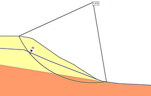
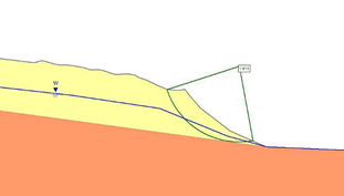
This study proposes a geotechnical evaluation of the waste rock dump of the Gaspar Simões Mine (Fig. 1), located in the municipality of Dom Feliciano/RS. The aim is to evaluate the geotechnical stability of the structure in its current state and consider its proposed capacity expansion. The Gaspar Simões Mine explores limestone in an open pit that covers an area of approximately 2.5 hectares and currently has three benches that are 12 meters high. In the deposit, the ore is distributed in lenses that are sometimes intercalated with gneisses and granites. On average the orebody has a cover varying from 4 to 10 meters, and the soil layers range in thickness from a few centimeters to less than 2 meters.
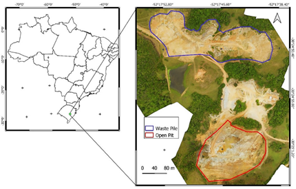
The WRD is located in the useful area of the enterprise and is made up of waste rock from mining, consisting predominantly of rocks fitting the calcitic marble ore, including granites, gneisses, and saprolite. In the studies previously presented for the environmental licensing of the project, a conservative geometry was proposed empirically, and, at the time, a reconfiguration of the WRD was considered. The original proposal foresaw a configuration with slopes of 10 meters high, 45° slope, and 4-meter berms. However, this plan would require extensive intervention and result in significant costs.
This study aims to certify the stability of the WRD in the current geometry conditions and to verify the feasibility of its expansion and final configuration, considering the need for mining advances.
2. Methodology
In order to evaluate the current situation of the WRD and the final configuration proposal, the methodology exposed in the flowchart of Fig. 2 is used. This methodology combines both quantitative and qualitative analysis. To perform the quantitative evaluation, a limit equilibrium analysis was chosen to determine the Safety Factor (SF), and the qualitative evaluation was used to classify the WRD and subsidize the project. Additionally, the qualitative analysis consisted in applying the methodology developed by Aragão [3].
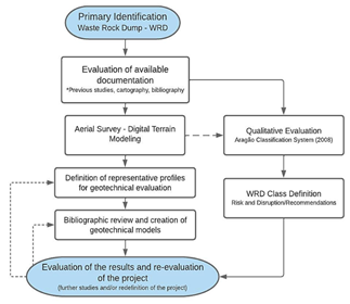
The methodology is partly based on defining representative profiles and evaluating geotechnical models based on them to enhance accuracy and validity. It is noteworthy that the utilization of Digital Terrain Models (DTM) allows the extraction of highly detailed profiles, and has been employed in several geotechnical works. Moreover, in this methodology, the use of Unmanned aerial vehicles (UAV) survey and DTM generation supports qualitative evaluation, by providing a more reliable and detailed interpretation of structural features. Thus, complementing the field inspections, the identification and mapping stages of the area are implicit. As a reference to the use of UAV and mapping methodology with application in geotechnical engineering, we can cite the works of Zekkos et al. [4], Fu-Hsuan et al. [5].
The results of the evaluation should be analyzed and, if necessary, further studies and/or design changes, such as geometry changes, should be defined. By conducting a qualitative analysis using the SF, it is possible to validate the parameters used in the models and gain insights into the need for additional studies or instrumentation. The flowchart of the applied methodology includes some optional flows, indicated by dashed arrows.
The initial phase consists of the preliminary identification of the WRD and the site to be evaluated, then evaluating existing and available documents, such as maps, plans, construction information, and characterizations of the materials of the pile and/or the deposit that is exploited. After that, the qualitative evaluation is started according to the classification system presented by Aragão (2008) based on technical information and geometric evaluations of the WRD. In parallel, mapping with UAV and image processing by digital photogrammetry allows both, to generate a DTM for the assessment of representative profiles for geotechnical evaluation, and information on geometric features and details for the qualitative evaluation. The final steps consist of evaluating the geotechnical models. Initially, it is recommended to evaluate the simpler models by equilibrium limits and parameter inference. However, in the final evaluation, if the results evaluated in conjunction with the qualitative evaluation are not satisfactory, the previous steps of the qualitative analysis should be reconsidered. Additional material characterization studies and stability evaluations can be performed using more robust methodologies such as the Finite Element Method (FEM) and/or the Discrete Element Method (DEM), among others.
The following goes through the steps of the applied methodology. First, a preliminary assessment and mapping of the area were performed with a UAV, which generated the images in Figs. 1 and 3. Next, quantitative and qualitative geotechnical assessments were performed. Finally, the results were evaluated together.
2.1. Waste dump situation and previous studies
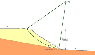
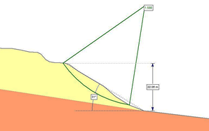
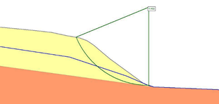
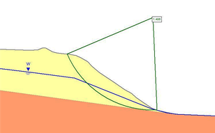
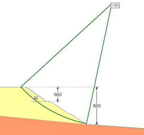
The Waste Rock Dump at Gaspar Simões Mine is in operation, and studies for environmental licensing purposes have been reviewed for 2021. Surveys were carried out and a proposal for reconfiguration to a more conservative geometry was made. Although a field test (SPT) was performed and used for parameter inference, it reached a depth of 0.80 meters in the WRD; reaching as expected the impenetrable - since the controlled WRD is composed of blocks of various sizes and compacted soil. As originally proposed, the project configuration was 45° slopes with a maximum height of 10 meters subdivided by 4-meter berms. Thus, an extensive redesign of the current WRD profiles with heights between 19 and 25 meters would be required. In such a proposal the SF would reach 3.29. In 2022 a new evaluation will be performed to verify the stability of the current situation and the new final profile proposal. As a basis for the study, the available documentation was used, and the structure was mapped with a UAV. Afterward, the images were processed in a GIS environment to verify the profiles and evaluate the geometries. Fig. 3 presents the DTM of the dump and the main profiles identified.
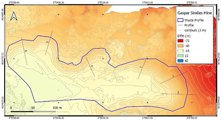
The WRD presents faces with an inclination limited to 35°, being in the east sector with a maximum height of 25 meters and an average height of 20 meters. The inclination of these faces is approximately 30°. On the west sector, the WRD presents a face angle between 34° and 38°, and its bench height ranges from 12 to 16 meters. An expansion is planned for the western sector, which in its final configuration intends to regularize the maximum slope up to 35°.
Based on the Digital Terrain Modeling (DTM), the slope primitive of the WRD area can be estimated. In the area of interest, there is a slight to moderate slope, on the order of 10% in the eastern portion of the WRD (area of profiles 1, 2 and 3) and on the order of 5-7% in the western portion (area of profiles 4, 5 and 6). No accumulation of water or humidity is observed around the WRD which would allow us to assume any degree of internal saturation. This information is relevant for qualitative and quantitative evaluation.
3. Geotechnical evaluation
Mining waste rock is naturally formed by the stripping of the ore, constituted mostly by rocky fragments in the saprolite matrix. The typical characteristic is the high grain size of the waste rock, due to the economy applied in the disassembly of the material from the blasting, reaching the grain size of boulders, chips, and blocks. Given the high granulometry, it is common to consider the angle of repose of the materials for projects since the deposition occurs by the launching of a sterile. However, for geotechnical stability assessment, it is pertinent to evaluate other parameters such as natural density, cohesion, and angle of friction.
Table 1 Summary of resistance parameters for waste rock material
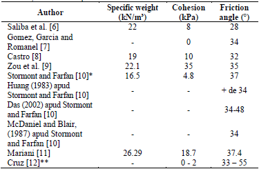
*Limestone waste rock material. **General rockfill.
Source: Author
Several methodologies are presented in the literature for evaluating the stability of waste rock dumps. This usually can be done by numerical methods (finite element, discrete, among others) and mainly by using the limit equilibrium method, with the Mohr - Coulomb failure criterion, for example, considering rupture by internal shear of the material, on a preferential circular surface.
Regarding the parameters of the model, waste rock dumps have great limitations regarding the direct determination/estimation of their strength properties, with limited access to data and publications regarding the results of field and/or laboratory tests. Therefore, strength estimates based on the observed angle of repose and/or theoretical data from literature are common for materials with similar grain sizes.
It is relevant to point out that divergence occurs regarding the value considered for cohesion, whose occurrence is related to the characteristics of the matrix where the larger fragments are embedded, and/or the scale of the structures. Table 1 presents a survey of resistance parameters considered in literature by the Mohr-Coulomb criterion.
The average parameters of friction angle higher than 35° and the recurrent value of 37° can be highlighted. As for cohesion, this presents a greater variation, being null in purely granular materials, but usually referenced with the value of 10 kPa in studies that consider granulometry variation, with emphasis on the work of Stormont and Farfan [10], also by Mariani [11] who evaluated material visually similar to the composition of the waste material matrix.
For specific weight, a tendency to scale on the order of 20 kN/m³ is observed, a value that is consistent with rock density (25-27 kN/m³) combined with voids and weathered soil/rock filling the voids. It is worth noting that the previous study, which estimated the parameters from the SPT value, used a cohesion value of 75 kPa and an angle of internal friction of 40.7°. It should be observed that these values, especially cohesion, present an extremely high value. Therefore, the geotechnical parameters for stability evaluation were reevaluated to reflect reality, resulting in a more conservative evaluation compared to the previous one. The evaluation considered a specific weight of 20 kN/m³, cohesion of 10 kPa, and angle of friction of 37°.
3.1. Stability analysis
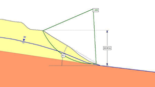
For the analyses, the software Slide 6 was used to create geotechnical models. For the stability analysis, the subdivision of the rupture surfaces into 25 lamellae was defined. For modeling the piezometric line, two hypotheses were considered, as recommended by NBR 13029 [13], with a real scenario (dry/drained) without the occurrence of a water level in the WRD and as a hypothetical scenario with the occurrence of a water level. As failure criterion, the Mohr-Coulomb criterion was used.
The Simplified Bishop Method, which takes into account circular surfaces, was used to determine the safety factors in this study due to its wide adoption in the literature as a rupture model. As a criterion of the critical water table level, saturation at the mid-height of the embankment was chosen. It is worth highlighting that this is a conservative estimate since the occurrence of saturation at this level is unlikely due to external drainage of the WRD, as well as its partially high-draining nature resulting from the variation in its granulometric composition. Thus, the hypothesis of saturation in the WRD is ruled out, although by regulation this should be considered in a hypothetical critical scenario. In the model results, the critical rupture surface and the piezometric line for the critical scenario are presented. Next, the results of both, the existing and the proposed WRD geometries are exposed, and the geotechnical models are considered.
Regarding Safety Factor recommendations, NBR 13029 [13], presents, according to Table 2 below, the Safety Factors recommended for waste rock piles. The height is limited to 200 meters, not specifying slope values and/or bench heights. However, to minimize environmental impact, it is emphasized that these should be observed regarding the SF of the structure, operability, and optimization.
Peck [14] comments that geotechnical studies can be divided into three levels of detailed investigation: (i) Based on limited geotechnical investigations and adopting conservative design approaches and high safety factors; (ii) Based on limited geotechnical investigations and evaluating recommendations based on regional practices; (iii) Carrying out detailed investigations.
This study is understood to be based on levels 1 and 2, presenting limited investigations and regional practices - given the investigations performed - and being based on regional practices (as to geometry and soil depths), both in inferring values and observing the stability of the existing structure in question and others in a similar situation.
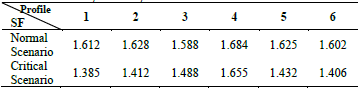
3.1.1. WRD current situation results
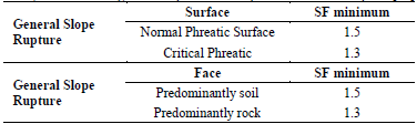
Figs. 4 to 15 present the results of the geotechnical models.
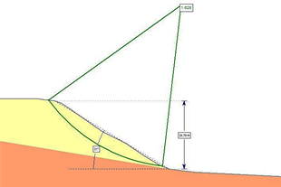
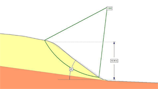
The Table 3 shows the safety factors obtained under the evaluation conditions.
3.1.2. WRD Final Configuration Results
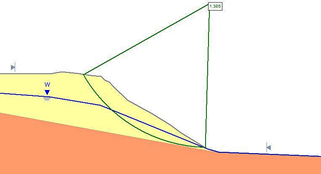
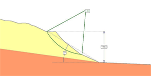
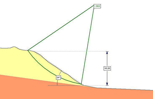
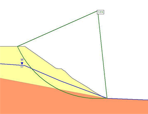
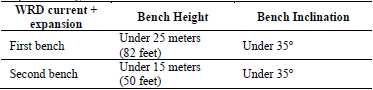
To expand the western sector of the current WRD, an additional bench is designed. The additional bench is 15 meters high, with a slope of 35° and a minimum berm of 5 meters (maintenance space). The stability evaluation showed an SF of 1.5 for the overall slope in the normal situation and 1.3 for the hypothetical situation with a water table occurring. The figures below (Figs. 16 to 19) refer to profiles 1 and 2 in their proposed final configurations.
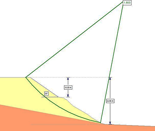
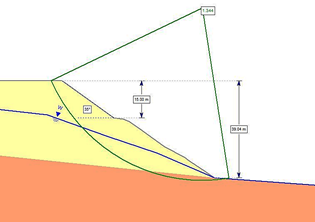
In areas where vertical advance had been delimited within the existing WRD and for the construction of a new one in the northern sector, the configuration of a first level with a 25-meter slope and 35° slope, and a second level with a 15-meter slope and 35° slope was proposed. Additionally, the use of a 5-meter berm was considered.
4. Qualitative evaluation
To conduct a WRD stability assessment on a qualitative basis, based on visual information, geomorphological features, WRD and terrain geometries, drainage, hydrology, and local and regional hydrography, Aragão [3] and Aragão e Oliveira Filho [15] presents a methodology-based stack classification system developed for the Canadian government based on the physical stability of a waste rock pile [16]. This methodology is recommended for evaluating WRD stability because it is useful and easy to apply, allowing the classification of WRD. Additionally, the system also presents, according to the classification, suggested monitoring measures. The complete tables can be found at Aragão [3].
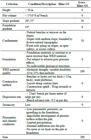
Tables 4, 5 and 6 present the application of the methodology for the WRD of the Gaspar Simões Mine, considering the current situation, projected expansion, and execution of the new pile projected for the northern area.
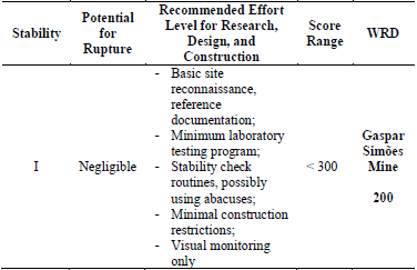
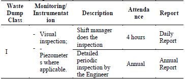
The current WRD is classified as Class I and the risk of rupture is negligible according to the method. Considering the expansions and final configuration of the WRD, it remains in Class I, highlighting that up to Class II, the risk attributed to potential rupture is low. For situations where applicable, visual monitoring, quantified evaluations by abacus, and instrumentation are recommended for these classes. In addition, even in the situation of expansion and final configuration, the WRD tends to maintain its classification based on geometry.
4.1. Geometric configuration
The Table 7 presents the geometric configuration proposed based on the evaluation performed. This configuration considered the qualitative and quantitative checks, which indicate feasibility for the implementation of the proposed configurations. It is noteworthy that the geometry proposition, besides geotechnical feasibility, is based on space optimization and impact minimization, reducing earth movement and impacts in a planned area; since it is understood that the stability is guaranteed in the updated proposed configuration (fitting the standard).
5. Conclusion
The methodology adopted proved to be adequate for the case in question. The results of the evaluations performed corroborated the understanding of the stability of the WRD in the current situation and its proposed expansion. The evaluation of limit equilibrium, performed on the profiles, presented SF consistent with that suggested in NBR 13029 [13]. This understanding is reinforced by the qualitative evaluation, which, due to the characteristics of the Stack/Storage, pointed to its stability - classifying it as low risk. Routine visual inspections are suggested to be conducted on a regular basis, and annually greater detailed inspections.
Considering that the geotechnical evaluation points to stability and low risk of the current situation and of the proposed expansion, we can conclude that the adoption of a more conservative geometry of the original project would represent an unnecessary financial and environmental cost. The current configuration already meets the stability and operational needs.
Regarding the methodology adopted, the potential for applications in the stability of other deposits or even other situations, such as excavated slopes and dams, is identified. However, the necessary adaptations regarding the qualitative evaluation must be observed. Following the example of this study, the geotechnical stability assessments can validate or point to configurations more economical for the enterprise and less impactful to the environment, by avoiding over-dimensioned structures.
In case the results of the evaluations are not satisfactory and or the qualitative evaluation points to the need for further monitoring and characterization, further material characterization studies should be carried out and/or other evaluation methods should be used. Among the possibilities of deepening are the realization of direct shear testing on the material to compose the embankment and the evaluation of stability via the finite element method (FEM) or discrete elements (DEM).

