


 English (pdf)
 Article in xml format
 Article references
 Send this article by e-mail
 Cited by SciELO
  Cited by Google
  Similars in
SciELO
Similars in
SciELO  Similars in Google
 Permalink
1. INTRODUCTION
The largest volume of sediment reaching the oceans is provided by rivers, with smaller additions associated with coastal erosion [1]. Thus, qualitative, and quantitative analyses of sedimentary accumulations in an ocean basin can help identify the relationship between deformation processes (dynamics and kinematics of key structures) and erosion of continental areas (Figure 1). Worldwide, part of these analyses have been focused on quantifying the volumes of classical flows in modern rivers, providing valuable information and models about erosion responding to different geological, climatic and even human activity effects [2]-[5], including the relationship with paleo seismological events [6]. However, this type of analysis represents short time scenarios - at most decades - showing the current state of tectonic regimes in continental areas, hindering the assessment of large changes to be observed on larger time scales [7]. Hence, another part of these analyses seeks to estimate volumes of sediment accumulated in ocean basins, which provide temporarily wider stratigraphic records (from millions to tens of millions of years) and to show the effects of the tectonic evolution of sedimentation margins [7]-[14]. In ocean basins with passive margins, these analyses have been useful for recognizing the effects of glacial erosion [15], [16], mantle like dynamics, and paleoclimatology [17]. On the other hand, the increase in geochronology and thermochronology data during the last decades has enabled the refinement of ages and magnitudes of regional and local orogenic events, supporting the quantitative analysis of sediment origins [18]-[21]. Thanks to these data sets, the analysis of sediment volumes accumulated in continental and marine basins have evidenced the relationships between tectonics, local erosion, climate change, mountain range exhumation, and evolution of continental margins [22]-[24].
In the northwestern Corner of South America (NWCSA), quantifications of clastic flow volumes derived from the Magdalena - Cauca River Basin (MCRB) have been performed, showing variable sedimentary load values between 144 to 184x106 Ton/year, close to those observed in rivers such as the Orinoco [25],[26]. The analysis of heavy minerals in sediments at MCRB shows a strong correlation with the geology of source areas, with predominance of heavy minerals such as zircon [27]. During the last three decades, numerous publications with geochronological and thermochronological data (U/Pb, AFTA), have allowed improved knowledge of ages of the crystalline basement rocks drained by the MCRB, as well as the age and rates of exhumation of the cordilleras in the NWCSA [28]-[33]. Despite this significant amount of data, there are no estimates of accumulated sediment volumes in Colombia's ocean basins, especially in the Caribbean, in the so-called Colombian Basin (CB), where the MCRB drains its sediments, forming the Magdalena Submarine Fan (MSF), which thickness can exceed 4,572 m, covering an area of 237,000 km2 and reaching distances of 450 km [34]. Neither is it known how much sediment has accumulated along the northern margin of South America since the late Oligocene, exceeding 3,657 m in thickness [35], [36], which gives rise to the so-called Southern Caribbean Deformed Belt (SCDB).
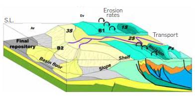
Figure 1 Conceptual sketch of a hypothetical sedimentary transport margins system from the source to sink by rivers in Converging modified from Grimaud [17]. Note how the eroded volumes (Ev) are stored in different parts (1S, 2S, 3S) until they reach their final repository, forming bypasses on the way (B1, B2) like underwater canyons on the slope or crossing mountain ranges.
This work is aimed at contributing to the geological knowledge of the Colombian Caribbean area with three main goals: a) to provide an updated chronostratigraphy of the CB and the SCDB for the interval covered between the Middle Miocene to the Holocene, based on the analysis of zircon provenances, integrating the data of regional seismic lines and stratigraphic wells drilled in the area; b) to show the variations in volumes of sediment accumulated in the CB - MSF and the SCDB during the Neogene - Quaternary (Figure 2), using regional 2D seismic programs (approximate area of 200,000 km2); c) to propose correlations between the volumetric variations of sediment accumulated in the CB-SCDB and the tectonic evolution in the NWCSA, taking into account published geochronological and thermochronological data, on an area of nearly 400,000 km2 (Figure 2), which covers the area of influence of the MCRB, the Sinu - San Jacinto mountain ranges, the Serranía del Perijá, and the Sierra Nevada de Santa Marta.
MORPHOLOGY OF THE NWCSA
The analyzed information allows the study of the Cenozoic tectonic evolution in the NWCSA and the CB (Figure 2). The NWCSA is morphologically characterized by the Western, Central and Eastern Cordilleras (including its northeastern extension known as the Serrania del Perija), which is bounded by two Longitudinal valleys of more than 400 km in Length, through which the Magdalena and Cauca rivers run (Figure 2). Both rivers join in the so-called Momposina Depression, then crossing the Serrania de San Jacinto and mouth into the Caribbean Sea, to the west of the Sierra Nevada de Santa Marta, giving rise to the MSF (Figure 2). Southwest of the San Jacinto Mountain range the Sinu River valley is Located, which mouth at north of the Sinu mountain range into the Caribbean Sea (Figure 2).
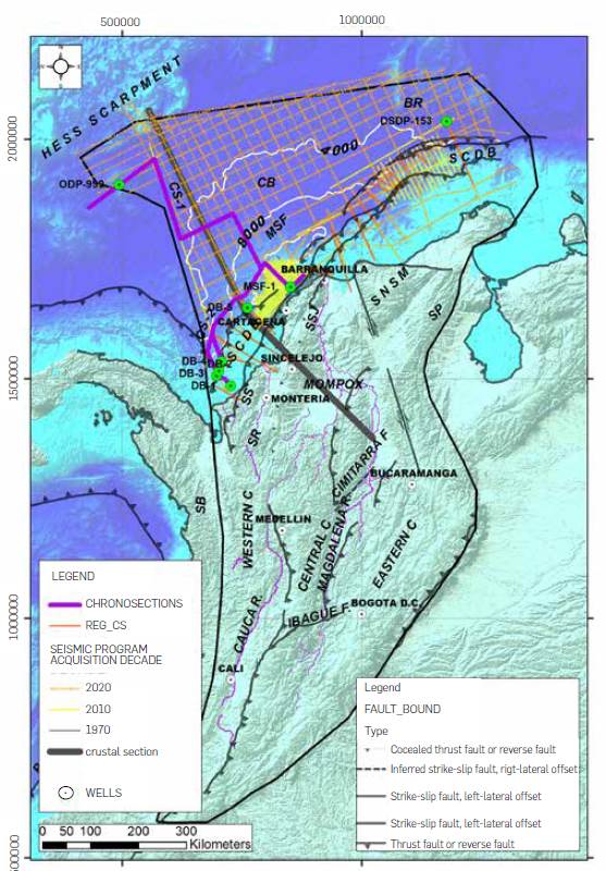
Figure 2 Generalized morphostructural map of the Northwestern Corner of South America (NWCSA) and the western Caribbean, highlighting the boundary between continental affinity crust of the South American Plate (Thick dark grey thrust fault in to the continent) and oceanic crust. The thick black line polygon delimits the analyzed area of the Western, Central, Eastern, Sierra Nevada de Santa Marta (SNSM), Serranía del Perijá (SP), Serranía de San Jacinto (SSJ), Serranía del Sinu (SS) mountain ranges and valleys drained by the Cauca-Magdalena (MCRB) and Sinu (SR River Basin), which flow into the Caribbean Sea. Note the expression of the Magdalena Submarine Fan (MSF - cone shape of white lines that represent the total thickness of sediments acumulated during the las 20 My) and the Southern Caribbean Deformed Belt (SCDB), which make up the southern limit of the Colombia Basin (CB), as well as the Hess Escarpment and the Beata Ridge (BR) which make up its northern and eastern limits. (MSF - cone shape of white lines that represent the total thickness of sediments acumulated during the las 20 My) It is also observed the distribution of the information of wells and lines used: a) Thick blue line: location of chronostratigraphic sections; b) Yellow points: location of stratigraphic and exploratory wells used; c) Decade: 2D seismic programs classified by decades from 1970 to 2020; 70:1970; 10: 2010; 20: 2020) d) Thick black lines: regional seismic sections of geometry control of the SCDB and the Sinu Lineament (Figure 11); e) The grey thick line shows the location of the crustal section (RCS) of Figure 3. f) white dots with black point in the center show the location of main cities
MORPHOLOGY OF THE CARIBBEAN COLOMBIA AREA
The northern Colombia offshore area is characterized by three major zones: continental shelf, continental slope, and ocean floor (Figure 2). The northern Colombia continental shelf zone shows Lateral variations in its width, from 50 km north of the Sinu River mouth and the Baja Guajira, to Less than 5 km on the northern flank of the Sierra Nevada de Santa Marta (Figure 2). Further, the continental slope zone has variable width, from more than 100 km west of the Serrania del Sinu and the Guajira, to Less than 50 km in the NW part of the Sierra Nevada de Santa Marta (Figure 2). A Large part of the slope zone forms the SCDB (Figure 2), characterized by dipping belts with a tectonic advance direction towards the NW [35], [37], except in the MSF area (Figure 2), where the high sedimentation rates seem to block the regional structural advance [38]. The sea floor area in the Colombian Caribbean has been referred to as the Colombian Basin, where depths exceed 3,500 mbsl, bounded to the south by the SCDB and the MSF, west and north by the Hess Escarpment, and east by the Beata Ridge (Figure 2).
GEOLOGY
From the Oligocene to the Holocene, the SCDB area and the Serranía del Sinu (Figure 3) have grown by structural stacking of sediment accumulated in the CB and the advance of MSF [35], [39]-[41]. The volcanic-sedimentary basement of the CB is covered locally by thin sequences of sediment, which do not exceed 800 m in thickness (Figure 3), accumulated in slope and outer shelf environments [42], from the Maastrichtian to Holocene times [43]-[45]. Sediment thicknesses tend to increase southwards, especially near the MSF and the SCDB, where they can reach 12,000 feet [36], [46]-[48].
The regional seismic interpretation controlled with wells drilled in the apex of the MFS and in the SCDB (Figure 3), show thicknesses that reach 4 km of sediment accumulated during the last 5 My, with the age of the lowest sequences found at more than 8 km depth remaining uncertain [49]-[51]. Tomographic inversion, GPS measurements, seismic reflection lines, and regional gravimetric models suggest that the Caribbean Plate currently subducts beneath the South American Plate (Figure 3), with low angle of the subduction plane near 5° [47], [52]-[54] and a convergence rate close to 2 cm/year [55], [56].
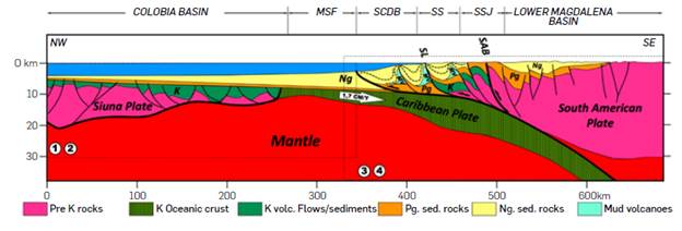
Figure 3 Crustal section through the Caribbean Plate and the NWCSA (See location on map in Figure 2). Note the thickness variations of the Caribbean Plate along the Colombia Basin and the volcanic-sedimentary (K) sequences that cover it towards the NW (especially in the area of the Siuna Plate), the thin sedimentary sequence of the Paleogene (Pg), as well as the increase in thickness of the sedimentary sequences accumulated from the mid-Miocene (Ng) towards the SW, in the area of the Magdalena Submarine Fan (MSF) and the Southern Caribbean Deformed Belt (SCDB), up to the Sinu Lineagment (SL). The area of the SCDB and the Serranía de San Jacinto (SS) present complex deformation, combined with mud volcanism (MV), extended to the limit with the South American Plate (SAB), product of the convergence with the Caribbean Plate. The numbers indicate the reference selected to build the section in the area limited by the dotted line polygons!) Ewing [46]; 2) Romito and Mann [47]; 3) Bernal-Olaya [52]. 4) López-Ramos [53]. The convergence rate of the Caribbean Plate is taken from Mora-Paéz [56].
Several works performed along the CB, in the lower part of the MSF and the lower slope of the SCDB, report the presence of several Mass Transport Complexes (MTC), with variable extensions, from less than 10 km to more than 100 km in length [40], [57], [58]. The 3D seismic data and high-resolution bathymetric information from MSF and SCDB, suggest that areas with Low sediment supply, high slope angle, and strong structural relief are capable of triggering mass movements of sediment [59]. It has also been possible to morphologically define the upper, middle and Lower part of the MSF, where submarine canyon systems, channel-Lobe systems, and turbidity currents are developed respectively [60]. Another geological element that characterizes the SCDB and part of the MSF is the presence of numerous mud volcanoes, with abundant manifestations of hydrocarbons of thermogenic origin [35], [39], [58], [61], [62].
MIOCENE - HOLOCENE CHRONOSTRATIGRAPHIC SETTING OF THE NWCSA - SCDB - MSF - CB AREA
During the Miocene - Holocene, the stratigraphic record of the NWCSA sedimentary basins shows that the sediments were mostly siliciclastic, accumulated from transitional to continental depositional environments (Figure 4). In sedimentary basins such as the middle and upper Magdalena Valley (Figure 4), the Honda and Real groups, as well as the Neiva, Mesa and Gigante formations, show that accumulation conditions were predominantly continental - meandering to braided rivers - with important volcanic and igneous-metamorphic contributions from the Central Cordillera [63]-[65]. West of the Central Cordillera, in the Cauca - Patía Basin, the sedimentation developed mainly in continental environments (Figure 4) - meandering and braided rivers - with important contributions coming from the denudation of volcanic formations [66], as well as rocks derived from the igneous and metamorphic basement of the Central and Western Cordilleras, as recorded by the Esmita, Ferreira, Amagá Superior, Cinta de Piedra, La Paila, Patía, Combia, Galeón, Popayán and Zarzal formations [30],[67],[68].
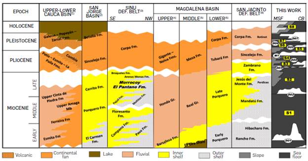
Figure 4 Chronostratigraphic correlation chart of sedimentary units accumulated during the Miocene - Holocene in the sedimentary basins of the NWCSA, MSF and CB. Note the predominance of continental and internal shelf depositional environments in the Magdalena and Cauca basins (with strong volcanic contribution during the Pliocene) and their transition to marine depositional environments in the Sinú, San Jorge, Magdalena Submarine Fan (MSF) and Colombia (CB) basins. The numbers refer to the selected author of the stratigraphic nomenclature of the basin: 1) Sierra and Marín - Cerón [67]; 2) Aguilera [72]; 3) Geotec [70]; 4) Ramon et al [101]; 5) ANH [102]; 6) Cardona et al [127]
To the north, in the Lower Magdalena Valley Basin, formations such as Mandatú, Jesús del Monte, Zambrano and Corpa (Figure 4), are interpreted as the product of siliciclastic accumulations in inner shelf environments [30],[39],[69], while in the area of the Serranía del Sinú, several formations (Campano, Floresanto, Moñitos, Pajuil, Morrocoy - El Pantano, Broqueles and Corpa) suggest a regional progradation of sediment accumulation in mangrove environments, developed in the upper deltaic plain [70], changing to deeper environments developed in continental slope zones [71]. Along the Serranía de San Jacinto, the vertical variation of facies between Rancho - Hibacharo and Mandatú - Perdices - Jesús del Monte formations suggest the gradual rise of a siliciclastic shelf with bioclastic contributions during the Miocene, while the transition between Zambrano, Sincelejo and Corpa formations suggests the advance of sediments accumulated in continental environments, during the Pliocene - Pleistocene [72],[73]. In the Caribbean offshore area, from the Sierra Nevada de Santa Marta to the Gulf of Urabá, some wells drilled predominantly in the shelf and upper slope zones showed the presence of sedimentary sequences accumulated from the late Miocene to the Holocene (Figure 4), predominantly in outer shelf and slope environments, prograding over the seafloor of the CB, as a result of the advance of the MSF, the sediments of which have been recorded in the ODP Site 999 [45],[48],[74]-[76]. To the west of the Sierra Nevada de Santa Marta, the wells drilled sedimentary sequences accumulated during the Mio-Pliocene, in siliciclastic shelf and upper slope environments [76].
DATA
This work integrated more than 28,000 km of 2D seismic reflection Lines, covering the entire Colombian portion of the CB, the MSF and the SCDB (Figure 2). The CB area is covered by seismic surveys acquired during the 2010 and 2020 decades, with recording times greater than 10 s twt, streamer Lengths greater than 9 km, and spacing between Lines of 25 km on average (Figure 2). These programs clearly show the geometry and distribution of sedimentary sequences, and their correlation with the underlying volcanic-sedimentary basement. The MSF area is covered with seismic programs, acquired in the 1970s and 2010s, with different acquisition parameters. The programs of the 1970s have recording times of Less than 7 sec and make the identification in some sectors of the seismic sequences at the base of the MSF difficult, while seismic data acquired in the 2010s have recording times greater than 12 sec and show the continuity of the seismic sequences identified in the CB up to the apex of the MSF (Figure 5). The geometry and thickness of sedimentary sequences in the SCDB area were controlled with regional seismic Lines acquired during 2004 (SPAN-2004 program), and some Lines of the 1994 regional program in the Sinu offshore area (Figure 2). These programs have acquisition parameters similar to those of the CB area, showing the regionally Large structures that make up the SCDB and its regional boundaries.
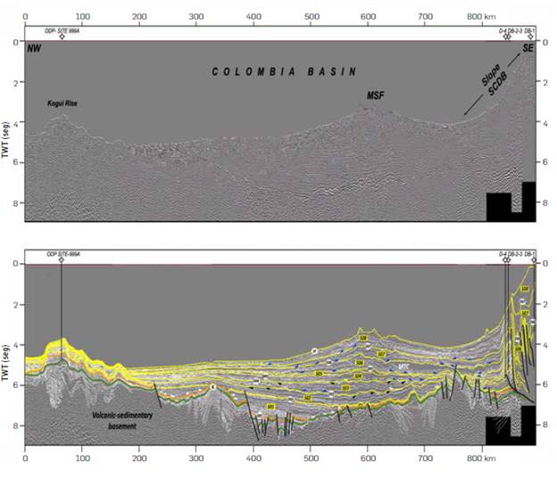
Figure 5 Above, uninterpreted CS-1 composite section (see location in Figure 2) and wells used for sequence age calibration from the northern margin of the Colombia Basin (Kogui Rise) to the South American continental slope, formed by the Southern Caribbean Deformed Belt (SCDB), through the middle of the Magdalena Submarine Fan (MSF). Below, section interpreted with: horizons used to build the Wheeler diagram of the basin (thin white lines), patterns of termination of seismic horizons marked with arrows (Black color: Truncations; Blue: Downlaps; White: Onlaps); Sequence limits in yellow color (white ovals indicate the sequence limit number from D01 to D07, M01 identifies the maximum flood surface); Delimited sequences (yellow boxes identify the sequence number from S01 to S08); Cretaceous volcanic-sedimentary basement limit (Green line identified with letter K); Paleogene sedimentary sequence limit (Orange line); MTC: Cartagena Mass Transport Complex from [114].
CHRONOSTRATIGRAPHY OF THE CB - SCDB - MSF
The age and composition of the seismic sequences interpreted during this work were calibrated with data from two stratigraphic wells (ODP Site 999A and DSDP Site 153), and 6 wells drilled mainly in the borders of the CB and MSF (Figure 2). The stratigraphic wells have a continuous biostratigraphic record, from the Cretaceous to the Holocene, as shown in charts of foraminiferous and calcareous nanofossils zones, as well as lithological and geochemical descriptions with great resolution and detail [43],[45]. In the remaining 6 wells, detailed biostratigraphic analyses were carried out, mainly from foraminifera and calcareous nanofossils recovered from cuttings. Ages obtained from micropaleontology were refined by integrating absolute data in detrital zircons extracted from 21 samples (recovered from 4 wells). Heavy minerals were separated by disaggregation, hydrauLic concentration, and gravitational separation, and selected zircons were measured with ICP - MS laser ablation (University of Washington). Additionally, absolute data was included on detrital zircons from 10 samples of Middle Miocene to Pleistocene sedimentary and volcanic rocks, recovered from outcrops located from the NW Antioquia up to Sierra Nevada de Santa Marta, to establish correlations with the sedimentary sequences drilled in the SCBD and MSF. Also, several published absolute data ages obtained by diverse methods in the Western, Central and Eastern cordilleras, were incorporated in this work, restricting the age of the radiometric data between 0 to 20 Ma. This information was especially useful in the identification of spatial and temporal regional volcanic and exhumation events. To use the U/Pb ages of the detrital zircons in the chronostratigraphic correlations, three conditions are required: a) the ages of the radiometric data obtained from zircon's must be less than 20 Ma; b) these zircons, with ages less than 20 Ma, were presumed to result from erosion of volcanic structures formed during the last 20 My in the NWCSA (mainly in the Central and Western Cordilleras); c) these products of the volcanic complexes were transported in relatively short times (>100 ky) by the MCRB to the SCDB - MSF - CB areas. Based on the foregoing conditions, it may be presumed that the zircons recovered from the offshore wells and outcrops of sedimentary units along the Sinu and San Jacinto mountain ranges accumulated more less at the same time along the SCBD - MSF - CB.
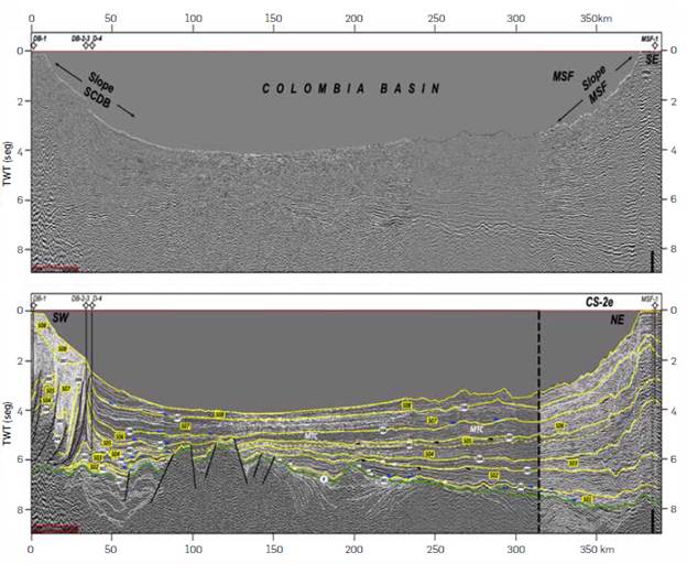
Figure 6 Above, uninterpreted CS-2 composite section (see location in Figure 2) and wells used for sequence age calibration along the North-South American margin, starting in the continental slope formed by the Southern Caribbean Deformed Belt (SCDB), passing through the southern part of the Colombia Basin and reaching the apex of the Magdalena Submarine Fan (MSF). Below, section interpreted with: horizons used to build the Wheeler diagram of the basin (thin white lines), patterns of termination of seismic horizons marked with arrows (Black color: Truncations; Blue: Downlaps; White: Onlaps); Sequence boundaries in yellow color (white ovals indicate the sequence boundary number from D01 to D07, M01 identifies the maximum flood surface); Delimited sequences (yellow boxes identify the sequence number from S01 to S08); Cretaceous volcanic-sedimentary basement boundary (Green line identified with letter K); MTC: Cartagena Mass Transport Complex [114]. The eastern part of the composite section (CS-2e), is part of the Wheeler diagram built in the sector of the Magdalena Submarine Fan (Figure 8).
To identify the stratigraphic sequences of regional extension in the area of the CB, the MSF and the SCDB, a chronostratigraphic correlation chart was built with existing seismic Lines and well data in the area, considering the methodological concepts proposed by Qayyum [77] and Snedden and Sarg [78] . The composite sections were defined by considering: a) the distribution of regional seismic reflection Lines, which cross the CB and the SCDB (Figures 5 and 6); b) proximity to wells with biostratigraphical and absolute U/ Pb ages (Figure 7); c) Location of areas with slight deformation (especially in the SCBD); d) sites with thick sediments (Figure 2), according to the Free Air Anomaly Satellite Map [79]. The composite sections were displayed with the conventional parameters for regional stratigraphic sequence interpretation defined by Snedden and Sarg [78].
Horizon ages were calibrated with wells projected onto the composite section and converted in time domain by Vertical Seismic Profiles or by the construction of check shots from other Logs. The tops of the ages defined by biostratigraphic or geochronological methods were pasted over these wells. The ages obtained by the micropaLeontological analysis were calibrated with radiometric data obtained from detrital zircons recovered from wells, which enabled assigning ages to horizon packages. The obtained ages were extrapolated to each seismic horizon and displayed in a Wheeler diagram plot that exhibits Large temporal hiatuses and their correlation with global eustatic sea Level variations (Figure 8). The identified hiatuses were used to define sequence boundaries, which were interpreted in the composite seismic section (Figures 5 and 6), mapped by undeformed sectors up to the apex of the MSF. Published data from zircon data by the U/Pb method were integrated into Wheeler diagrams (Figure 8) to establish possible correlations between source rocks drained by the Magdalena (MHRB) and Cauca (CHRB) river basins, as well as the Sinu and San Jacinto Mountain ranges (Figures 9 and 10).
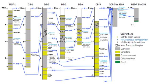
Figure 7 Correlation of wells used to calibrate ages of sedimentary sequences from the Miocene to the Holocene in the CB, the SCDB and the MSF (Wells location in Figure 5). The blue lines refer to the sequence boundaries defined in the Wheeler diagram constructed in the CS-1 and CS-2 (Figs. 5 and 6). The ages of the DSDP Site 153 and ODP Site 999A wells are taken from publications in the Caribbean [44], [129], [130]. Micro fauna in the wells accompanied by letter (R) suggests reworking processes.
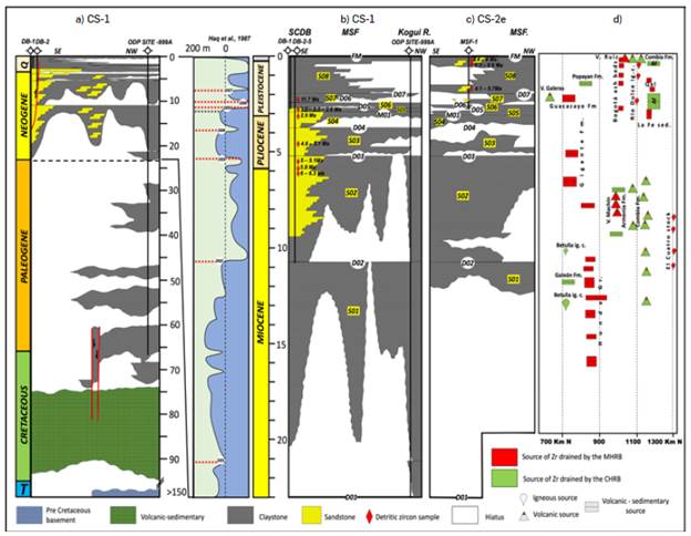
Figure 8 Regional Wheeler diagram (a) for the Colombia Basin (CB) and the Southern Caribbean Deformed Belt area (SCDB) and detail for the Miocene - Holocene interval (b) - CS-1 in Figure 5. On the right (c), - CS-2e in Figure 6 detail for the same time interval in the Magdalena Submarine Fan (MSF) area. Note the coincidence between the global eustatic curve [94] and the sequence boundaries during the last 20 My. D: Discordance; M: Maximum Flooding Surface; S: Sequence. South - North chronostratigraphic scheme (d), along the areas drained by the Magdalena (MRB) and Cauca (CRB) rivers, showing the chrono-spatial distribution of units with zircon contents with ages U/Pb lower than 20 Ma (location of selected samples in Figure 9). AF: Fluvial - volcanic Fans North of Combia.
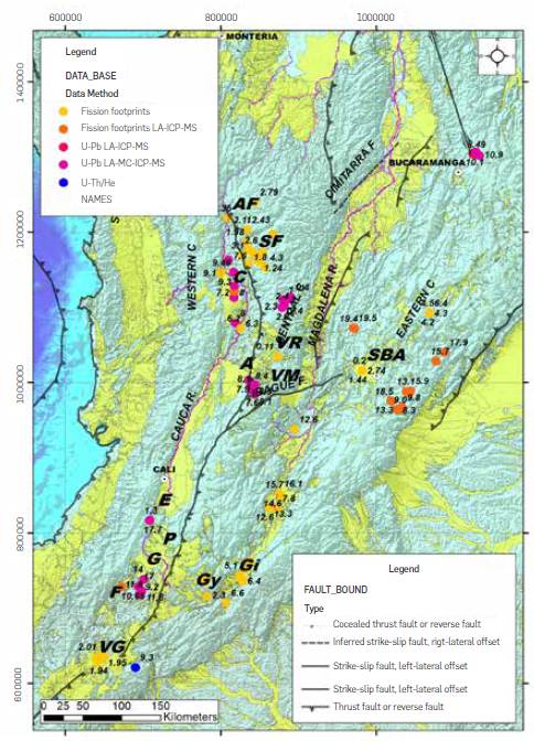
Figure 9 Map of Neogene - Quaternary age outcrops along the Magdalena (MRB) and Cauca (CRB) river basins. The points indicate the location of samples with detritic zircon recovery, analyzed by U/Pb method for radiometric age determination used in Figure 8d (Numbers indicate ages in Ma of the youngest zircon, taken from Gómez et al [33]. The letters in bold indicate the locations mentioned in the text: VG= Galeras Volcano; VM= Machín Volcano; VR= Ruiz Volcano; F= Ferreira Formation; Gy= Guacacayo Formation; Gi= Gigante Formation; G= Galeón Formation; P= Popayán Formation; E= Esmita Formation; A= Armenia Formation; SBA= Sabana de Bogotá Ash; C= Combia Formation; SF=Sedimentitas de la Fe; AF= Fluvial - volcanic fans.
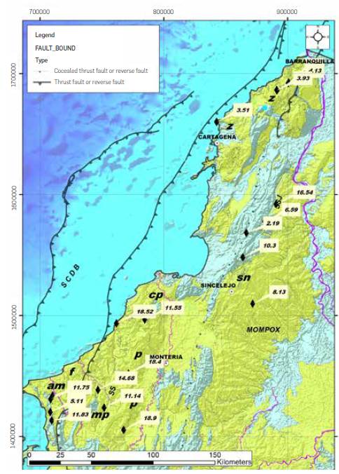
Figure 10 Map of Neogene - Quaternary age outcrops in northwest of Colombia, along the Sinu (SS) and San Jacinto (SSJ) moutain range taken from [33]. The black diamonds show the location of samples recovered during this study, with recovery of detritic zircons, analyzed by U/Pb method for radiometric ages (Numbers indicate ages in Ma of the youngest zircon). Bold letters refer to the locations and stratigraphic units mentioned in the text: mp= Morrocoy - El Pantano; am= Arenas Monas; p= Pajuil; cp= Campano; sn= Sincelejo; z= Zambrano; f= Floresanto; SS=Serranía del Sinú; SSJ= Serranía de San Jacinto.
ESTIMATION OF ACCUMULATED VOLUMES IN THE CB, MSF AND THE SCDB
To estimate the volume of sediment accumulated in the CB and MSF, the sequence boundaries defined during the construction of the Wheeler diagram in the time domain were followed in the different seismic surveys. Subsequently, time grids of each sequence boundary were constructed and converted to depth using a velocity model calibrated with the wells in the area. The construction of the velocity model used available data of seismic refraction in the area [46], to control the top of the volcanic-sedimentary basement in particular. Velocity uncertainty can be close to 5% in zones without well control (especially CB), and can be associated with lateral Lithological changes in areas with minor deformation. The uncertainty is greater in areas of the SCDB, where the presence of thrust faults and stratigraphic Levels submitted to overpressure can Locally affect the velocites. Although there is uncertainty about the age of the first sediments accumulated over the volcanic-sedimentary "basement" of the Caribbean Plate in the CB area, their thicknesses are considered minimal compared to thicknesses accumulated during the Last 20 My. Finally, the value of the current water column was subtracted from each grid, so that only the values of the sedimentary thicknesses are presented.
It is well known that the northern margin of the NWCSA is convergent, subject to subduction during the Paleogene [54], [80], [81]. However, the eastward rate of displacement of the Caribbean Plate seems to remain close or accelerated with respect to the current values of 2 cm/y [82], [83] measured by the GPS campaigns [56], with a very Low subduction angle [52]. These conditions have Led the northern margin of Colombia, especially the SCBD, to behave as a structural stacking zone [35], [37], [41], with lateral variation of shortening percentage, where the amount of sediments included in the subduction is very Low, Leaving a Large part of them involved in the SCDB. Consequently, regional cross sections and seismic sections were reviewed [34], [36], [84] to project the surfaces up to the Sinu Lineament [39], suggesting an average angle for the fault plane of 25°, with reverse movement, advancing structurally towards the NW (Figure 11). Near the trace of the Sinu Lineament, the depth of the CB and MSF sequential boundaries were projected horizontally up to the fault plane, as controlled by several points extracted along the seismic sections (Figure 11). In each extracted point, the hanging wall sedimentary thickness and the current water column (Figure 11) were removed. These values were interpolated along the footwall block of the Sinu Lineament, producing grids of each boundary surface. The resulting grids along the SCDB were merged with the grids constructed in the CB and MSF. The thickness values along the SCDB have an important uncertainty, which can reach up to 10% of the calculated value, directly Linked to the structural complexity that characterizes the area.
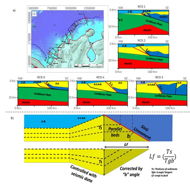
Figure 11 Regional geological sections used to estimate the angle b=25° of the Sinu lineament (L.S. panel a) and location map of Regional cross sections (RCS) 1 to 4 [34], [36]; RCS 5 [131. Below (b), explanatory diagram of thickness estimation from the limit of the Colombia Basin to the dipping fault between the recent and old deformed belts. The thicknesses of the sequences were taken from the engages of each sequence interpreted in the Colombia Basin (C.B.), while in the Southern Caribbean Deformed Belt (SCDB) and the Serrania del Sinu (S.S.), it was controlled with 2D regional seismic lines (sections 1 to 15 in the map). The thicknesses in the recumbent block of the S.L. were considered parallel to its intersection with the fault plane and were corrected to surface considering the b angle.
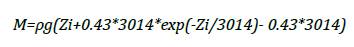
The resulting grids of the CB - MSF and the SCDB became points, with a 5 km spacing between them. Each grid of points in each sequence was used to calculate the weight of accumulated sediments at each point of the grid, using the equation developed by Metivier [85]. The reconstruction technique used to produce a conservative mass balance of the volumes accumulated in the CB - MSF basin implies studying compacted, rather than decompacted, strata to thus estimate the sediment mass. Calculating mass from sediment thickness implies knowing how densities vary with depth based on the equation:
Where:
M: Accumulated sediment mass in kg per unit area
pg: Grain density 2,700 kg/m3
Zi: DePth of the sequence to be decompacted
To estimate the total weight of accumulated sediments per unit area, the value obtained at each point was multiplied by the area of each cell, which in this case is 25 km2. Finally, the values obtained from each cell are added and the total accumulated weight is obtained from 0 m to the depth of each point. Applying this equation in each grid of points (boundaries between sequences), and calculating the total accumulated weight per unit area, the value between grids is subtracted, resulting from the value of the accumulated sedimentary weight between top and base of each sequence. Dividing this value by the average grain density yields the volume of sediments accumulated between surfaces. Finally, integrating data from wells in the Lower, Middle and Upper Magdalena Valley sub-basins, as well as in the Cauca - Patía sub-basins, total thickness grids of sedimentary sequences accumulated during the last 18 My were constructed. The grids obtained were recalculated with the procedure previously described for the offshore domain and allowed to estimate the total volume accumulated in the continental basins.
OROGRAPHIC UPLIFT OF THE NWCSA
To identify, both spatially and temporally, the uplift and volcanic events in the NWCSA, data published in the Catalogue of Radiometric Data of Colombia [33] were compiled, as well as data from recent articles (Figure 9), selected at ages of less than 20 Ma. These ages were classified in categories, depending on the mineral in which the dating was defined (Apatite, Zircon, Hornblende, Biotite) and the technique used (U/Pb, Hf, He, K/Ar). Apatite data were mainly used to detect areas exhumed during the last 20 Ma, using exhumation rates from 0.1 Km/My to 3Km/My, to define ages of surface exposure of the mineral earlier than the current age (0 Ma). The radiometric data from zircons, hornblendes, and biotite, as well as in intrusives (especially along the Central and Western Cordilleras), served to define periods and areas of volcanism, which are important to define probable sources of sediment and regional processes responsible for the volumes of sediment accumulated in the area of the CB -MSF - SCDB.
NEW CHRONOSTRATIGRAPHY OF THE CB - SCDB - MSF AREA
The seismic-stratigraphy work (Figures 5 and 6), combined with the micropaleontological and geochronological analyses (Figure 7) , enabled the definition of 8 seismic sequences accumulated during the Last 18 My in the area comprised by the CB, the SCDB and the MSF (Figure 8), named Neogene sequences 1 to 8 (S01 to S08). One of the sequences was subdivided, using the maximum flooding surface M01, given its Large extent and thickness (Figure 8) . Regionally, it is observed that these sequences cover discordantly and prograde onto the sequences of volcanic-sedimentary basement of the Caribbean Plate, of Pre-Maastrichtian age, and Paleogene sedimentary sequences (Figures 5 to 8). A general description of the identified sequences characteristics in seismic Lines, Lithology drilled, ages and origins are presented below.
S01: The base of this sequence is defined by the unconformity D01, with regional extent marked by truncation and onlap patterns (Figures 5 and 6), well defined in the area of the MSF, especially at the edges of partially reactivated grabens (Figures 5 and 6). On the axis of the grabens, in the front of the MSF, a concordant pattern is observed at the base of the sequence. Internally, the sequence is characterized by continuous, parallel, seismic reflections, with laterally variable amplitude that tend to be medium to high towards the MSF, and to decrease towards the Kogui Rise area. This sequence has been drilled in the distal part of the CB by the ODP Site 999A well in the Kogui Rise and by the DSDP Site 153 well in the Beata Ridge (Figure 8), which biostratigraphy suggests a depositional age from Burdingalian to Serravalian (Figures 7 and 8). In the Sinu and San Jacinto Mountain range area, U/Pb data in detrital zircons, recovered from Floresanto and Campano formations, show radiometric ages between 19 and 11 Ma (Figures 4 and 10). This age range is also observed in zircons recovered from formations such as Galeón, Esmita and Ferreira, as well as the Betulia igneous complex in the southern part of the Cauca River basin, while to the north of this basin, they are found in basal sections of the Combia Fm. In the MHRB, zircons of this age are reported in layers of the Honda Group (Figures 8 and 9).
S02: The sequence S02 rest discordantly over sequences of the CB basement and prograding on the S01, configuring downlap patterns in the distal part of the MSF and the SCDB that allow to define the unconformity D02 (Figures 5 and 6). Seismically, continuous parallel reflections patterns are observed in the CB that vary to wavy - discontinuous at the base of the MSF and the SCDB (Figures 5 and 6). The sequence has been drilled in the distal part of the CB, by the wells ODP-999A and DSDP-153, where the biostratigraphy suggests an age of accumulation from Tortonian to Messinian (Figures 7 and 8). In the southern part of the CB, along the SCDB, the DB-2 well drilled the top of this sequence, recording interfingered sandstones and mudstones (Figure 7). The U/Pb data in detritic zircons recovered by the DB-2 well show an age range of 5 to 6 My, similar to the micropaleontological ages estimated at the top of this sequence (Figures 7 and 8). In the southern part of the Sinu mountain range, samples recovered in the Arenas Monas, Morrocoy - El Pantano and Pajuil formations, contain detritic zircons with U/Pb ages of 5 to 7 My, as well as in the Sincelejo Fm. to the east of Sincelejo city (Figure 10). Throughout the CHRB, numerous samples obtained south and north of Cali show U/Pb ages between 10 and 5 My in zircons from formations such as Armenia and Lower Combia, while to the east, along the MHRB, similar ages are reported by the same method in outcrops of the Gigante Gr., and around the Machin Volcano (Figures 8 and 9).
S03: The base of this sequence is defined by the unconformity D03, distinguished by truncation and downlap patterns, with well expression in the MSF area (Figures 5 and 6). The sequence covers a large part of the offshore Caribbean Colombian area, internally characterized by parallel wavy seismic reflections that are predominant in the CB area, with variable amplitude, tending to be mounded to chaotic towards the MSF (Figures 5 and 6). This sequence has been drilled in the distal part of the CB, by the ODP Site 999A and DSDP Site 153 wells, as well as in the SCDB by the DB-2 and DB-5 wells (Figure 7), where sands interfingered with mudstones are reported, accumulated in deep sea floor depositional environments at the base of the slope. The biostratigraphy of the stratigraphic wells, drilled in the northern edge of the CB, as well as in wells drilled in the SCDB, suggest that this sequence was accumulated at the beginning of the Zanclean (Figures 7 and 8). The U/Pb ages obtained from detritic zircons recovered from DB - 2 and DB -5 wells, show ranges between 4.6 and 5.1 Ma, confirming a minimum Lower Pliocene age for this sequence (Figures 7 and 8). In the southern part of the Sinu mountain range, detritic zircons recovered in the middle part of the Arenas Monas Formation show ages of younger zircon with values of nearly 5.1 Ma, close to the ages reported in samples with zircons recovered from the wells drilled in the SCDB (Figure 10).
S04: The base of this sequence is defined by the regional unconformity D04, marked by truncation seismic patterns and down Laps (Figures 5 and 6). Internally, the sequence is characterized by mound-shaped seismic reflections, with variable amplitude, concentrated in the MSF area, which vary Laterally towards the CB to continuous, parallel, variable amplitude, slightly wavy seismic reflections. Like the oldest sequences, this sequence has also been drilled by the ODP Site 999A in the northern edge of the CB, over the Kogui Rise and Beata Ridge (Figure 8), where mudstones, accumulated in deep water environments are reported, while towards the SCDB, the DB-2 and DB-5, wells report Levels with sandstones interfingered with Laminated mudstones (Figure 7). The biostratigraphy suggests a Piazencian age for the accumulation of this sequence (Figures 7 and 8). The ages obtained by U/Pb method in detritic zircons show variable ranges between 11.3 Ma towards the base and 12.1 Ma towards the top of the sequence (Figures 7 and 8). In the Sinu mountain range and the southern part of the San Jacinto Mountain range, formations such as Sincelejo, Pajuil, FLoresanto, Morrocoy - EL Pantano and Arenas Monas, contain sediments with detritic zircons with U/Pb ages between 18 to 10 Ma, with predominance of ages between 11 and 15 Ma, similar to those recovered in the wells DB-4 and 5 in the offshore in sequence S04 (Figures 8 and 10). To the north, near Barranquilla, detritic zircons with U/Pb ages of 4.1 to 3.5 Ma have been recovered in numerous Locations of the Zambrano Formation (Figure 10), very close to the ages of the younger zircons recovered from wells drilling the S04 sediments in the offshore domain. Along the MHRB, samples taken south of Medellin, in outcrops of the Sedimentitas de La Fe Fm, contain detritic zircons aged between 3.5 and 2.5 Ma (Figures 8 and 9).
S05: The S05 sequence concordantly overlies the S04 sequence; this sequence is split by the M01 marine flooding surface (Figures 5 and 6). This sequence is characterized by parallel continuous seismic reflection patterns in the CB, which change to discontinuous seismic reflector, wavy patterns, at the base of the MSF and the SCDB (Figures 5 and 6). The sequence has been drilled in the northern border of the CB, by the ODP Site 999A and DSDP Site 153 stratigraphic wells, where mainly mudstones accumulated in deep marine depositional environments (Figure 7) are reported, while towards the area of the SCDB and the MSF it has been drilled by DB-2 and DB-5 wells, where Levels of fine-grained sands interfingered with claystone are reported. The biostratigraphy suggests that sediments of this sequence were accumulated between Late Piacencian to early Gelasian (Figures 7 and 8). Samples with zircons recovered in DB - 02, DB - 03, DB - 04 and DB - 05 wells (Figures 7 and 8), show U/Pb ages of: 9 My; 8.7 My; 3.2 My; 2.6 My and 2.3 Ma. Considering these, the oldest ages, they are interpreted as the product of erosion of pre-Pliocene units and the population of younger zircons, as the closest to the age of deposition of the sequence. Several samples with U/Pb ages in detritic zircons between 2 and 3 Ma are Located north of Cali - along the Cauca River - in rocks of the Combia Fm (Figure 9). The U/Pb ages obtained from zircons recovered from samples of the Sedimentitas de La Fe and Quaternary Alluvial Fans north of Combia, show ages between 3 and 2.5 Ma (Figures 8 and 9). Petrographic analyses developed from sandy Levels recovered from the middle and upper parts of the S05 sequence, drilled by the DB-5 well, show zeolite type cement, which tend to increase from 5% to over 15%. This significant content of zeolite is closely related with tuffaceous and porous volcanic rocks, mainly andesitic, rich in calcic plagioclases.
S06: The unconformity D05 defines the base of the sequence S06, marked by bidirectional downlap patterns under the MSF area (Figure 5). Internally, this sequence is characterized by continuous parallel seismic reflections, with variable amplitude, mainly towards the front of the SCDB to mounded in the area of the MSF (Figure 6). Between the MSF and the SCDB, this sequence presents chaotic seismic reflection patterns, with frequent erosive Levels at the base, facies interpreted as the expression of Mass Transport Complexes MTCs (Figure 6). This sequence has been drilled by the wells Located along the SCBD, reporting predominantly mudstones, accumulated in sedimentary environments of continental slope and basin plain. In several wells Located between the SCDB and the CB there are numerous slump structures (Figure 7), which confirm the occurrence of the MTCs observed in the seismic Lines. The micropaleontological analyses suggest that this sequence was accumulated during the Late Gelasian (Figures 7 and 8). From this sequence, no zircons were recovered in the analyzed wells; however, the petrographic analyses show contents higher than 10% of zeoLites as the cementing material. The U/Pb ages obtained from zircons recovered from samples of the Sedimentitas de La Fe and alluvial fans north of Combia, show ages between 2.5 and 1.8 Ma, as well as in volcanic ash in the Sabana de Bogota area (Figures 8 and 9).
S07: This sequence is bounded at the base by the unconformity D06, defined by downlap termination patterns, bi-directional under the MSF area and progradation in the SCDB area (Figures 5 and 6). Internally, the sequence is characterized seismically by reflections with shapes of mounds extended by tens of kiLometers, with variable seismic amplitude, concentrated in the MSF area, which vary Laterally towards the CB to continuous, parallel, very Low amplitude, slightly wavy seismic reflections. This sequence has been drilled in the northern part of the CB, in the Kogui Rise and the Beata Ridge areas (Figure 7), where mudstones accumulated in deep water depositional environments are reported, whiLe towards the SCDB, all analyzed wells that drill this sequence, report mainly mudstones with very fine grain sand intercalations, which towards the MSF tend to be coarse grained (Figure 7). The biostratigraphy suggests that this sequence was accumulated from middle to Late Calabrian (Figures 7 and 8).
The U/Pb ages of detritic zircons recovered from MSF-1 and DB-2 wells indicate a range from 4.1 to 11.7 Ma for the S07 sequence sediment sources (Figures 7 and 8), which is older than the ranges of age recovered from underlying sequences. In the Sinu mountain range and the southern part of the San Jacinto Mountain range, formations such as Sincelejo, Pajuil, FLoresanto, Morrocoy - EL Pantano and Arenas Monas, contain detritic zircons that yield U/Pb ages in ranges between 4 to 5 Ma. Some parts in the north of the San Jacinto Mountain range- South of Barranquilla - Layers of the Zambrano Fm. - contain detritic zircons with U/Pb ages between 4.1 to 3.5 Ma (Figure 10). In the southern part of the MHRB, Layers of the Guacacayo Fm. contain detritic zircons with ages of 2.5 to 1.8 Ma, while south of the CHRB, Lavas from the Galeras voLcano contain zircons of this age, alike the alluvial fans north of Combia (Figures 8 and 9).
S08: This sequence represents the Last episode of sedimentation in the Caribbean offshore of Colombia, bounded at the base by the unconformity D07, defined by patterns of downlap seismic reflections, bidirectional in the area of the MSF and progradation towards the CB in the SCDB, with variable amplitude. Internally, it is characterized by mounded seismic reflections in the MSF and SCBD area, varying to slightly wavy parallel seismic patterns towards CB, with variable to Low amplitude (Figures 5 and 6). This sequence is present in all the wells studied - except in DB-05 well - showing a predominance of mudstones interfingered with some Levels of sandstones, accumulated in slope and basin floor depositional environments in the SCDB and CB, while in the MSF, the sandstones tend to be coarse-grained, accumulated in outer shelf depositional environments (Figure 7). The biostratigraphy suggests an age of deposition for this sequence between late Calabrian to Holocene (Figures 7 and 8). In this sequence, it was possible to recover detritic zircons whose U/Pb ages tend to be very young towards the base of the sequence, with values between 0.3 and 0.6 Ma, while they tend to be older towards the top, with ranges between 2.4 and 5 Ma(Figure 7). There are no reports of so young ages in the Sinu and San Jacinto mountain ranges as those found at the base of sequence D08 in the MSF-1 well (Figure 10), but they are regionally extended along the CHRB and MHRB (Figure 10), as a result of the activity of the Nevado del Ruiz volcano in the Central Cordillera, and the final phase of volcanism of the Combia Fm. in western Antioquia (Figures 8 and 9).
ANALYSIS OF ACCUMULATED SEDIMENTARY VOLUMES
The isochore maps constructed for each of the 8 sequences (SOI to S08), mapping along the CB, the MSF and the SCDB area, lead to estimate that a total of 2.06x10¹⁵ Tons were accumulated equivalent to 761,111 km3 during the last 17.9 My (Figure 12). The minimum accumulation time span estimated for the sedimentary sequences, as defined from the chronostratigraphic analysis, is 0.15 My, while the major time span of accumulation being 6.61 My (ratio > 40 between the minimum and maximum value), with an average duration of 2.23 My. The rates of sedimentary accumulation vary from 54 MTons/y, to 802 MTons/y (ratio > 14 between the maximum and minimum value), with an average of 235 MTons/y. The relationship between the accumulation time of each sedimentary sequence and their sedimentary rate indicates that, at a short accumulation time span, the sedimentary rates tend to increase, while the total sediments accumulated per sedimentary sequence tend to be greater as the accumulation time span increases (Table 1).
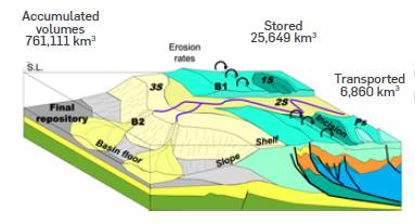
Figure 12 Sketch of a hypothetical sedimentary transport system from the source to sink by rivers in converging margins and the values of retained and accumulated volumes of sediments calculated during this study.
Table 1 Summary of results obtained during the calculation of accumulated sediment volumes (decompacted) in the area of the CB, SCDB and MSF for each sedimentary sequence, the accumulation time period (BEGIN and END columns in millions of years), area covered by the sequence (Km2), weight (TONS= Tons), volumes (Km3) and accumulation rates (TONS/My= Tons per million years; MTONS/Y= Millions of tons per year and Km3/My= Cubic kilometers per million years)
| Sequence | Begin Ma | End Ma | Covered Area km2 | Total ACC Tons | Volume km3 | Tons/Ma | Mtons/y | km3/Ma |
|---|---|---|---|---|---|---|---|---|
| S01 | 17.91 | 11.62 | 275,400 | 8.44E+14 | 312,594 | 1.34E+14 | 134 | 49,697 |
| S02 | 11.62 | 5.01 | 260,400 | 3.61E+14 | 133,565 | 5.46E+13 | 55 | 20,206 |
| S03 | 5.01 | 3.52 | 255,100 | 2.31E+14 | 85,619 | 1.55E+14 | 155 | 57,463 |
| S04 | 3.52 | 2.70 | 252,050 | 1.43E+14 | 52,912 | 1.74E+14 | 174 | 64,526 |
| S05 | 2.70 | 2.36 | 249,200 | 1.00E+14 | 37,107 | 2.95E+14 | 295 | 109,138 |
| S06 | 2.36 | 2.21 | 24,525 | 1.20E+14 | 44,588 | 8.03E+14 | 803 | 297,251 |
| S07 | 2.21 | 1.69 | 245,825 | 8.57E+13 | 31,737 | 1.65E+14 | 165 | 61,033 |
| S08 | 1.69 | 0.00 | 243,325 | 1.70E+14 | 62,991 | 1..01E+14 | 101 | 37,273 |
The total thickness maps constructed for the Magdalena and Cauca sedimentary basins, allow us to estimate that about 7.16x10¹³ Tons have been captured during the last 20 My, equivalent to 25,649 km3 (Figures 12 and 13), of which: 7.64x10¹³ Tons (2,830 km3) are captured in the Valle del Cauca Basin; 1.72x10¹³ Tons (6,380 km3) in the Lower Magdalena Valley Basin; 4.67x10¹³ Tons (17,300 km3) in the Middle and Upper Magdalena Valley Basins. Thus, the total amount of sediments accumulated in the CB, the MSF, the SCDB and the Magdalena and Cauca basins during the last 20 My would be 2.13x10¹⁵ Tons, equivalent to 786,760 km3. These results show that 96.6% of the sediments accumulated during the last 17.9 My are found in the CB, the SCDB and the MSF, while only 3.4% of the sediment volume is confined in the Magdalena and Cauca sedimentary basins. A detail of the results achieved in the estimation of sediment volumes in each sedimentary sequence identified in the CB, SCDB and MSF is summarized in Table 1. Each sequence defined along the CB, SCDB and MSF, presents particular thicknesses, volumes and geometries produced during its accumulation, response mostly to the accommodation space, the sedimentary supply, and the location of the entry points from major rivers.
S01: This sequence marks the beginning of the great sedimentary contributions in the CB area, provided by the South American continent, extending over an area of 275,000 km2 (Figure 14) accumulating 8.44x10¹⁴ Tons, equivalent to 312,594 km3 (Table 1) Considering the time during which this sequence was accumulated (6.92 Ma), it is estimated that the accumulation rates reached 1.34x10¹⁴ Tons/My (-134 MTons/year) or 49,697 km3/My (Table 1 and Figure 15). The greatest thicknesses in this sequence, greater than 2,000 m, were concentrated in an elongated strip, heading east to west, nearly 200 km wide, and over 300 km long. The axis of this strip is parallel to the direction of regional magnetic anomalies observed in the CB area [47],[86],[87], a zone characterized by east-west strike normal fault systems, which mainly affected the basin's basement and preserve remnants of Mesozoic sediments (Figure 5). Another area with thicknesses greater than 2,000 m, although less extensive, is observed to the west of the Sinu mountain range, involved in the deformation of the SCDB (Figure 14).
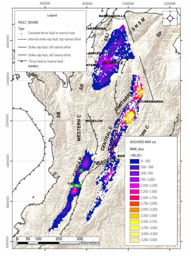
Figure 13 Isochore map of sediments accumulated during the last 18 My in the sub-basins of the Cauca - Patia, Upper, Middle and Lower Magdalena Valley, built from the information of exploratory wells (white points) and geophysical surveys (yellow points).
Figure 14 Isochore map in meters of sediments of the sequence SOI (not decompacted), accumulated during the Burdingalian to Serravalian time in the CB, SCDB and MSF. Note the orientation of E - W of the largest thicknesses of the sequence, similar to the orientation of magnetic anomalies recorded by Christofferson [86]
Figure 15 On the left graph of sedimentation rates in Millions of tons per year (upper axis) and in cubic kilometers per million years (lower axis), in the Colombia Basin during the last 17.9 My, as well as the chronological position in each sequence (named in yellow rectangle), of the zircons recovered in the studied wells (yellow rhombuses). Note the low sedimentary rates in the interval from 11.6 to 5.01 Ma in the study area, similar to the current ones and the extremely high ones developed between 2.36 and 2.21 Ma. In red the trend of global surface temperature [131], in black the global eustatic change curve [93] and the age of the MTCs previously identified [59],[115],[126] . On the right, relative frequency graph of the ages obtained by fission analysis in apatite's (thick black dotted line) and phases of magmatism from other dating methods (blue to red degraded polygons called phases 1 to 4) in the NWCSA, based on the age compilation [33] and the temporal position of the detritic zircons recovered during this study (yellow rhombuses) in the Sinu and San Jacinto mountain ranges (see sample locations in Figs. 9 and 10). It is possible to differentiate regional exhumation phases, phases of magmatism (1 to 4) and groups of detritic zircons in the Caribbean of Colombia (3 major and one minor).
S02: During the time span since 11.6 Ma to 5.01 Ma (6.5 My), sediments of the S02 sequence accumuLated, covering an area of approximately 260,000 km2 (Figure 16). During this time interval, 3.61x10¹⁴ Tons were accumulated, equivalent to 133,565 km3 (Table 1). Considering the volumes and time in which the sedimentation of this sequence developed, the estimated accumulation rates reached 5.46x10¹³ Tons/My (-55 Mtons/y) or 20,200 km3/My, thus being the period with the lowest sediment accumulation rates in the area during the Cenozoic (Table 1 and Figure 15). The isochore map of this sequence shows that thicknesses greater than 1,500 m are concentrated in the SCDB area, configuring a symmetrical lobe shape, more than 400 km wide and long, with ejection direction towards the NW (Figure 16), while in the area of the CB the average thicknesses is close to 500 m.
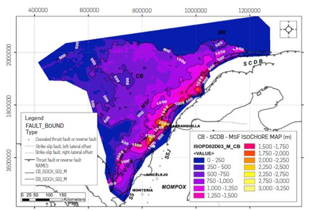
Figure 16 Isochore map in meters of S02 sequence sediments (not decompacted), accumulated during the Tortonian to Messinian in the CB, SCDB and MSF. Note the concentration of thicknesses greater than 1,000 m along the SCDB and the shape of the lobe with NW ejection trend.
S03: The S03 sequence, accumulated in the CB from 5.01 My to 3.52 Ma (1.49 My), covers an area of 255,100 km2 (Figure 17), which corresponds to a volume of 2.31x10¹⁴ Tons of sediments, equivalent to 85,619 km3 (Table 1). The accumulated sediment volumes during this time interval, lead to estimate a rate of 1.55 x 10¹⁴ Tons/My (-155 MTons/year) or 57,463 km3/My (Table 1), three times greater than the values of the accumulation rates calculated for the underlying sequence S02 (Figure 15). Alike the S02 sequence, it is observed that thicknesses greater than 1,000 m are concentrated in the central part of the SCDB, decreasing to an average of 500 m thickness in the CB (Figure 17). The isochore map for this sequence, suggests a fan shape, with less than 100 km wide, less than 200 km long, and NW direction of ejection (Figure 17).
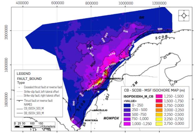
Figure 17 Isochore map in meters of sediments of sequence S03 (not decompacted), accumulated at the beginning of Zanclean in the CB, SCDB and MSF. The map shows a distribution of areas with greater thicknesses at 1,000 m, concentrated in the central part of the SCDB and of 500 m predominantly in the CB.
S04: The sediments in this sequence were accumulated between 3.52 My to 2.70 My (0.82 My), covering an area of 252,050 km2 (Table 1). The total volume of sediments accumulated for this sequence was 1.43x10¹⁴ Tons, equivalent to 52,912 km3 (Table 1). This sedimentary volume was accumulated in the area of the CB and the SCBD at rates of 1.74x10¹⁴ Tons/My (~174 Mtons/y) or 64,526 km3/My, exhibiting a slight increase with respect to those recorded in the underlying sequence S03 (Figure 15). The isochore map of this sequence shows an average of 500 m in the area of the CB, the SCDB and the MSF, with thickness close to 1,000 m in dispersed areas (Figure 18), which have an elongated lobe shape, more than 300 km wide and less than 200 km long, arranged along the SCDB (Figure 18).
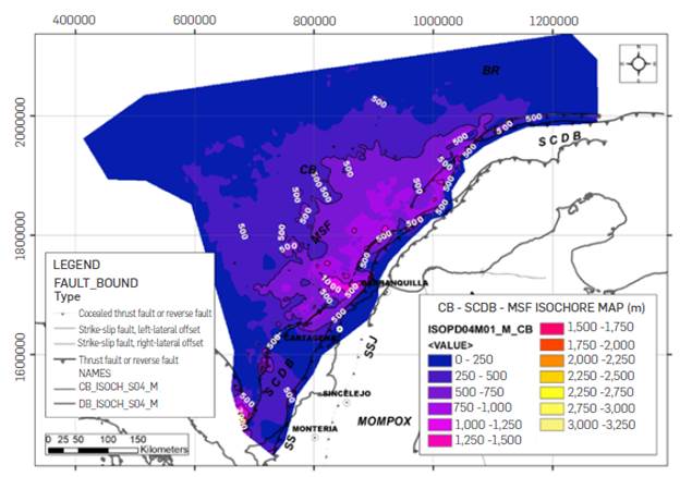
Figure 18 Isochore map in meters of S04 sequence sediments (not decompacted), accumulated during the Piazencian in the CB, SCDB and MSF. The map shows an important reduction in the thickness of sediments accumulated along the SCDB and a smaller extension towards the CB.
S05: This sequence was accumulated between 2.70 to 2.36 Ma (0.34 My), covering an area of 249,000 km2, accumulating 1.00x10¹⁴ Tons, equivalent to 37,106 Km3 (Table 1). This sedimentary volume accumulated at rates of 2.95x10¹⁴ Tons/My (~295 MTons/year) or 109,137 km3/My, almost doubling the sedimentary rates of the underlying S04 and S03 sequences (Figure 15), marking an important increase in the volumes of sediments that reached the Colombia Basin from the South American continent. On average, 500 m thick sediments were accumulated in the area, concentrating the largest thicknesses in the SCDB and the MSF, suggesting a slight lobular elongated shape, which decreases towards the CB area (Figure 19).
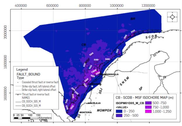
Figure 19 Isochore map in meters of S05 sequence sediments (not decompacted), accumulated from the end of Piazencian to the beginning of Gelasian in the CB, SCDB and MSF. The map shows an important reduction in the thickness of sediments accumulated along the SCDB and a smaller extension towards the CB.
S06: This sequence accumulated between 2.36 My to 2.21 My (0.15 My), over an area of 247,525 km2, a sediment volume of 1.20x10¹⁴ Tons, equivalent to 44,588 km3 (Table 1), reaching an accumulation rate of 8.03x10¹⁴ Ton/My (-803 MTons/year) or 297,251 km3/My, it being the period with the highest sediment accumulation rates in the basin during the Cenozoic (Figure 15). Seismic and some well data suggest the presence of MTC's with regional extension in this sequence (Figures 5 to 7). This sequence records an average thickness of 500 m over the entire area, increasing locally to more than 1,500 m into the west of the Sinu mountain range, and up to 1,000 m northwest of Cartagena, showing in this area, a slightly elongated lobe shape, less than 100 km wide and about 200 km long (Figure 20).
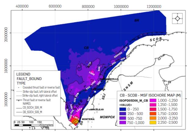
Figure 20 Isochore map in meters of sediments of sequence S06 (not decompacted), accumulated at the end of the Gelasian in the CB, SCDB and MSF. The map shows an important local extension depocenter in the west of the Sinu mountain range and a lobe of more than 100 km northwest of Cartagena.
S07: During the time span between 2.21 to 1.69 Ma, an area of 245,825 km2 was covered by sediments in the CB, the SCDB and the MSF, accumulating a volume of 8.57x10¹³ Tons of sediments, equivalent to 31,737 km3, with rates of 1.65 x 10¹⁴ Tons/My (~165 Tons/year) or 61,033 km3/My, decreasing to one fifth of the accumulation rates recorded in the underlying sequence (Figure 15). The greatest thicknesses of this sequence are concentrated to the west of Barranquilla, where they reach more than 1,000 m, forming a small, slightly elongated lobe, less than 100 km wide and long, which towards the central part of the CB and the SCDB decrease to 500 m, and less to the north (Figure 21).
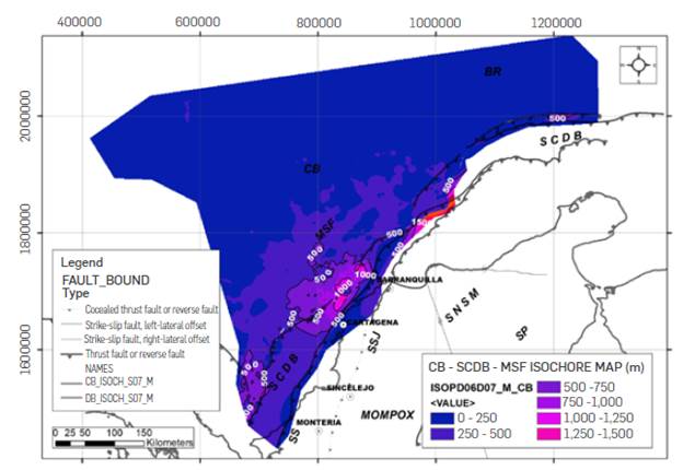
Figure 21 Isochore map in meters of S07 sequence sediments (not decompacted), accumulated from mid to end of Calabrian CB, SCDB and MSF. The map shows a concentration of thicknesses greater than 1000 m northwest of Cartagena, with a slightly elongated lobe shape.
S08: This sequence marks the end of the great sedimentary contributions to the CB from the South American continent during the Cenozoic. During the last 1.69 My, 243,000 km2 of the CB, the MSF and the SCDB were covered with sediments, accumulating 1.70x10¹⁴ Tons, equivalent to 62,991 km3 (Table 1). The sediments of this sequence were accumulated at rates of 1.01x10¹⁴ Tons/My (~101 MTons/year) or 37,272 km3/My, constituting the second period with the lowest sedimentary rate in the basin during the Cenozoic, following that occurred between 11.6 My and 5.01 My (Figure 15). The greatest thicknesses in this sequence, over 1000 m, are concentrated in the northwestern part of Cartagena, showing an elongated lobe shape and depocenters included in the SCDB, to the west of the Sinu mountain range (Figure 22).
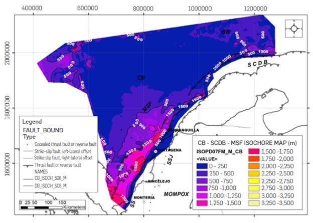
Figure 22 Isochore map in meters of S08 sequence sediments (not decompacted), accumulated during the last 1.6 My in the CB, SCDB and MSF The map shows a concentration of thicknesses greater than 1000 m northwest of Cartagena, with elongated lobe shape and retained in the SCDB west of the Sinu mountain range.
EXHUMATION EVENTS AND VOLCANIC ACTIVITY AT THE NWCSA DURING THE NEOGENE
The ages obtained in apatites (by fission tracks), Ar - Ar, K - Ar, U -Pb (especially in zircon) and U - Th/He in the NWCSA, compiled in the Colombian Radiometric Catalog [33], allow making a selection of those with ages lower than 20 Ma, with wide geographical distribution and density (Figures 2 and 9). This information, added to the ages of the detritic zircons obtained during this study in wells and outcrops of the Caribbean of Colombia, allows to define ages and regions subjected to exhumation or volcanic activity, along the Colombian mountain ranges, as well as their correlation with the volumes of sediments accumulated in the CB, SCDB and the MSF (Figure 15).
The relative frequency of ages obtained by fission tracks in apatites (Figure 15), suggests that during the interval between 20 My and 13 Ma, the central zone of the Eastern Cordillera presents a progressive exhumation pulse, as proposed by several works [31], [88]-[90]. A new exhumation pulse occurs between 12 and 8 Ma, prior to exhumation pulses in the Central and Western Cordilleras occurring at 6 and 4 Ma (Figure 15). This second pulse was recorded in palynological studies and paleo-gemorphological studies along the NWCSA [28],[73],[91],[92]. The relative frequency of ages obtained by other methods (Ar - Ar, K - Ar, U/Pb in zircons and U/ Th-He), shows 4 distinct phases (Figure 15). The first phase occurs between 20 and 15 Ma, with a maximum number of reported ages in 17 Ma, corresponding with samples concentrated in the southern part of the Cauca Basin - Patia and central-southern part of the Central Cordillera (Figures 8, 9 and 15). The second phase occurs between 14 and 6 My, with a maximum relative frequency of ages in 8 My, geographically concentrated in samples obtained from the Machin volcanic complex and the Combia volcanic complex (Figures 8, 9 and 15). The third and fourth phases occur during the last 3 My, showing the fluctuation between the volcanic activity in the southern part of the Cauca-Patia basin and the volcanic activity of the Nevado del Ruiz volcano and the Combia area in the central and northern part of the Central Cordillera (Figures 8, 9 and 15).
The U/Pb ages in detritic zircons recovered from layers of the Morrocoy - El Pantano, Corpa and Sincelejo formations along the Sinu and San Jacinto mountain ranges (Figures 4 and 10), can be divided into 3 major temporal groups, one basal from 20 to 16 Ma, another from 12 to 10 Ma and another between 4 and 2 Ma, as well as a smaller one between 8 and 6 My (Figure 15). The group of detritic zircons with ages between 20 and 16 Ma, has a good correlation with the first phase of volcanism, concentrated mainly in the southern Cauca-Patia Basin (Figure 9). The next group of zircons, aged 12-10 Ma, appears to correspond with the beginning of the second phase of volcanism, concentrated in the Machin and Combia area, as well as a strong exhumation period in the Eastern Cordillera (Figure 15). The less relative frequency of zircons group, with ages between 8 and 6 My, coincides with the ages associated with the maximum activity of the volcanic complexes in the Machin and Combia areas (Figures 9 and 15). Finally, the group of zircons aged between 4 and 2 Ma, shows agreement with the ages reported for the volcanic activity of the southern Cauca Basin and the most recent period of exhumation of the Eastern Cordillera (Figures 9 and 15).
The wells analyzed along the SCDB and MSF show U/Pb ages in detritic zircons that are consistent with the last three phases defined in the relative frequency analysis described above (Figures 7 and 15). The age of the zircons between 6 and 5 Ma in the S02 sequence is very similar to that of the detritic zircons reported in sedimentary sequences of the Sinu and San Jacinto mountain ranges between groups 2 and 3 (Figure 15). This occurs, similarly, with the ages of sequences S03 to S07, very close to those of Group 3 zircons analyzed herein, mixed with Group 2 zircons. Lastly, the sequence S08 show zircons with ages close to the ages of the high relative frequency in Group 4 (Figure 15).
SEDIMENTARY EVOLUTION DURING THE LAST 20 MY IN THE CB, THE SCDB, THE MSF AND THE TECTONIC EVOLUTION OF THE NWCSA:
The sedimentary evolution described in this study shows that the CB area, the SCDB and the MSF have a dynamic and continuous stratigraphic record for the last 20 My, as suggested by previous works in the marginal areas [43]-[45],[48]. However, analysis supported on the construction of detailed Wheeler diagrams, controlled with biostratigraphic analysis and geochronology from detritic zircons, allows to define sequence boundaries and regional maximum flooding surfaces. The sequence boundaries identified and calibrated in a chronostratigraphic manner (D01 to D07) are consistent with 3rd and 4th order global eustatic sea level changes defined by Haq [93]. Only the D05 and D06 boundaries are part of a large eustatic fall at the beginning of the Pleistocene (Figure 8). It is also noted that the maximum flooding surface M01 has a well correlation with a 3rd order global eustatic sea level rise (Figure 8). Although the validity of the eustatic cycles described by Haq [93] is debated because its low resolution [94], or because it is felt that sequence stratigraphy is rather an artifact than an empirical data-based method [95], does not imply that the origin of the sequences described during this work can be considered purely glacio-eustatic, since. In a tectonically active area, such as the NWCSA, signs related to volcanic events, mountain range exhumations, collisions and climatic changes are observed, as will be discussed hereunder.
The sedimentation rates in the CB - MSF - SCDB area, show an important dispersion between the minimum and maximum values, reaching a ratio of 14, as well as a great dispersion between minimum and maximum times of accumulation, reaching a ratio of 40. Additionally, it is observed that as the temporary interval of the studied sequence is smaller, the sedimentation rate tends to increase (Table 1). The wide distribution in the accumulation times and sedimentary rates ratio, raise uncertainty about the continuity of the stratigraphic record in the basin. This lack of continuity in the stratigraphic record is observed in the chronostratigraphic analysis, where a great number of hiatuses between the identified sedimentary sequences are shown, suggesting that the sedimentation process was not equal in the whole area at the same time (Figure 8). The seismic reflection patterns at the base of these sequences indicate a gradual progradation of sediments from the NWCSA to the CB (Figures 5 and 6). This leads to conclude that in the sedimentary sequences (especially those that accumulated in time intervals greater than the average, during the Miocene - Early Pliocene), their areal distribution is limited and close to the continental supply area, which tends to increase towards the top, where the CB is widely covered. On the other hand, it should be considered that during the Miocene, the Caribbean Plate was located at approximately 400 km to the east of its current position, as deduced from the current rates of relative movement estimated by GPS [56] and paleogeographic restorations [96]. This paleogeographic position moves the NWCSA sedimentary source away from the Colombia Basin, decreasing its sedimentary accumulation rates to values close to those estimated for distal ocean floors. In this scenario, it can be stated that sedimentation rates in sedimentary sequences with large span of times are variable, tending to be low towards the base of the sequence (beginning of the progradation's over the basin) and increasing towards the top (maximum progradation of the sequences), in a paleogeographic position far from the NWCS sedimentary source during the Miocene. The opposite behavior is observed in the sedimentary sequences accumulated during the last 5 My, characterized by short periods of sedimentation, low total accumulated volumes, and high sedimentation rates. This increase in the sedimentary rates in sequences accumulated in short time spans, can be the result of a combination of greater temporal discrimination of sequences and a gradual approach of the Caribbean Plate to the sedimentary source of the NWCSA. Additionally, during this period of increased sedimentary rates, the global surface temperature tends to decrease, from 18°C to 13°C on average. Hence, the results obtained from the sedimentary rates, their variation, and possible links with events in the NWCSA, are discussed in two groups of sequences: a first group of sequences accumulated before the union of the Cauca and Magdalena rivers hydrographic basins (Sequences S01 and 02) and a second group of sequences accumulated after the union of both hydrographic basins (S03 to 08).
SEDIMENTARY SEQUENCES ACCUMULATED IN THE CB BEFORE THE UNION OF THE CAUCA - MAGDALENA RIVERS
As it can be deduced from its extension and seismic expression, the SO1 sequence covers a paleo-topography resulting from normal faults, which dislocated mainly rocks of the Cretaceous volcanic-sedimentary basement of the CB (Figures 5 and 6). Although there are several published works that show this type of normal faults in the Cretaceous basement [47], [97], it is generally described as the top of a rough basement. The S01 sequence isochore map suggests a linear filling, with an E-W heading, following the magnetic lines initially described by Christofferson [87]. The origin of these magnetic lineaments has not been discussed in depth, and only some authors consider them as the product of regional extension processes [87]. Taking into account the geometry shown in the isochore map of the S01 sequence, consistent with the magnetic lineament (Figure 14), it is possible to consider, from 17.91 Ma to 11.62 Ma, sediments from NWCSA progressively covered from east to west, a rift formed during the Cretaceous, approximately 200 km wide by 400 km long, at a rate of 134 MTon/y (Table 1 and Figure 15), slightly lower than the current sedimentary transport rate recorded for the Magdalena River of 144 MTon/y [25]. The relationship between sedimentary rates calculated for the sequence S01 (134 MTons/y) and the area of drainage transporting sediments to the basin (supposing a similar area to that currently drained by the Magdalena and Cauca river basins of 227,000 km2), is very similar to the current relationship and trend defined for watersheds draining mountainous areas in Asia or Oceania (Figure 23).
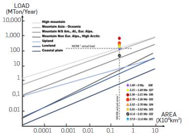
Figure 23 Global load relationship (vertical axis) vs. river basin area (horizontal axis) in different topographic areas [5] and the position occupied in this relationship by the current area and load of the Magdalena - Cauca River Basins -MCRB - according to the values calculated in previous works [25]. Note the variation in the sedimentary load for each sedimentary sequence (S01 to S08), estimated from the analysis of accumulated sedimentary volumes in the CB, SCDB and MSF during the last 18 My.
During this time span, in the Eastern Pacific Basin, the Cocos Plateau and the Malpelo Ridge are separated by the Sandra Rift [98], a period during which there is an incipient uprising of the Eastern Cordillera according to Apatite fission-track data [90], [91], under tropical- neotropical conditions based on fossil plant assemblages [92]. Along the course of some regional structures such as the Itsmina Deformation Zone in the Pacific Coast and the Sinu Lineament, basic- ultrabasic intrusive complexes suggest an important lithospheric adjustment during the Miocene in the NWCSA [71], [99], which constrain the development of sedimentation along the CPRB [67]. Towards the south of the Cauca - Patía basin, extensive igneous and volcanic-sedimentary complexes were developed [100], which were the source of sediments that fed an intramountainous basin formed between the Central and Western cordilleras [30]. Between the Central and Eastern Cordilleras, important sedimentary sequences were accumulated in continental environments, with strong volcanic contributions along the Upper and Middle Magdalena Valley basins [64],[101],[102].
Some paleogeographic reconstructions for the early Miocene show a deltaic development over 500 km long and 300 km wide, along the current San Jorge Basin, the Sinu mountains, and the southern part of the SCDB, suggesting that the course of the Cauca was directed to the Caribbean Sea during this time, while the Magdalena River would restrict its outlet to the Plato Basin [73], [84]. The proposed mouth of the Cauca River to the Caribbean Sea through the San Jorge Basin would explain the presence of detrital zircons recovered along the Sinu mountains (Figure 10), considered in this paper as Group 1 (Figure 15). This group of zircons is very close to the phase 1 of magmatism (Figure 15), which was concentrated in the southern part of the Cauca River Basin - Patía, giving rise to the Galeón Fm [101] or the Betulia - Cerro Gordo - Dominical Igneous Complex [103]. The current position of the area with the greatest accumulated thickness in sequence S01 is located to the north of the SNSM, about 400 km to the West of what could be a mouth of the Cauca River, into the CB through the area of the Serranía del Sinú. Taking into account that the current rate of relative movement between the Caribbean and South America plates is approximately 1.8 cm/year [56], it is possible to consider that at 20 Ma the area of greatest thickness of the S01 sequence in the CB and the SCDB would be 360 km west of NWCSA [96], very close to the mouth proposed by Flinch [85] for the deltaic system associated with the Cauca River. Therefore, it can be considered that the rift and graben system with a general east-west direction present in the CB was predominantly covered by sediments transported by the Cauca river, coming from the inter-mountainous basin formed between the Central and Western cordilleras, with a topography to similar to the existing one (Figure 24).
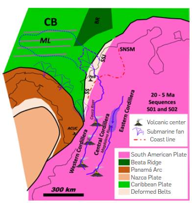
Figure 24 Paleogeographic sketch of the NWCSA and the Caribbean for the Miocene (accumulation time of the S01 and S02 sequences). Note the direct exit of the Cauca River to the Caribbean, transporting sediments derived from active volcanic centers, filling rift and graben structures with E-W orientation, which show magnetic linings (ML), while the Magdalena River seems to form a lake system in the central part [90]. During this time, intrusive and basaltic lava flows develop in the Pacific such as the Alto Condoto Ultramafic Complex (ACUC) and in the Sinu mountain range the Puerto Escondido Basalts (PeB), probably linked to cortical fractures with a strong course component. Position of the Panama Arch modified from [56]
During the interval between 11.62 and 5.01 Ma, sediments corresponding to the S02 sequence were accumulated, extending over a large part of the CB, the SCDB and the MSF, covering the previous sedimentary sequence (Figure 16) with thin thicknesses. The isochore map suggests that the structural fabric of the CB base still controlled the distribution of sediments in the basin during this time, although with less expression than that observed in the preceding S01 sequence. This sequence accumulated at an average rate of 55 MTons/year, it being one of the lowest estimated for the area during this study, with half of the sedimentation rate currently recorded by the Magdalena River (Figure 15). The relationship between the sediment load and the drainage area (assuming an area similar to that of the MCRB), would show topographic conditions very similar to the current ones, being lower than those interpreted for the preceding sequence (Figure 23). The relative frequency of ages obtained from ages of apatites published in several Papers (Figure 15), suggests a regional uplift phase in the Eastern Cordillera area between 14 to 8 Ma, while the relative frequency of ages obtained by other methods suggests the development of a second phase of concentrated volcanism in the Machin and Combia areas in the central and northern part of the Central Cordillera (Figures 9 and 15). The increase in the regional uplift in the Eastern Cordillera and the decrease in the volcanic activity in the Central Cordillera, reflecting the transition from a normal subduction to a flat subduction [104].
The U/Pb ages obtained in detritic zircons of Group 2 in formations such as Cerrito, Morrocoy - El Pantano, Pajuil and Corpa (Figures 3 and 10), show ranges very similar to this second phase of volcanism, indicating that they possibly acted as sediment source areas for the SCDB and CB zones. In the wells studied in the SCDB and MSF, zircons with Group 2 ages in the S02 sequence were not recovered, probably because this sequence has not been drilled entirely (Figure 7). However, the subgroup of detritic zircons, with ages between 8 and 6 My, recovered in the Sinu mountain range and South of the San Jacinto Mountain range, are also found in much of the S02 sequence drilled by the SCDB wells (Figures 10 and 15). This range of ages obtained from zircon's is very close to the maximum relative frequency of ages obtained by methods such as fission track in apatites [33], during the second phase of volcanism, developed mainly in the central and northern part of the Central Cordillera, evidencing that this was the main sediment contribution area for the S02 sequence. At the same time, changes in the floral composition from tropical lowland to subandean forest suggest local uplift of the Eastern Cordillera [92].
Despite the exhumation phase of the Eastern Cordillera and volcanism in the central and northern part of the Central Cordillera, the rates of sedimentary contributions to the CB-SCDB area were very low between 12 to 5 Ma (Figure 15), even lower than those in the Niger Delta, which drains a passive margin [17]. This type of lag between orogeny - volcanism and denudation - sedimentation rates, can be related to humid climatic conditions, which can decrease erosion and sedimentary transport rates [105], although experimental models suggest that the climatic signature in the fluctuations of sedimentary flows will be close to the value associated with the rate of uplift [106]. Current analyses of sedimentary discharges suggest that the greatest control in the sedimentation rate in ocean basins is given by the area of watersheds that transport the sediments [5]; nonetheless, it is possible that large hydrographic basins do not simultaneously respond to changing conditions [12], [107] or that drainage reorganization processes in sediment-source areas exert additional control [108]. This enabled us to consider that a river basin like the MCRB has not responded synchronously to regional uplift or climate changes, as reflected in the low rates of accumulation in the area of the CB - SCBD - MSF. It is also likely that local uplifts or obstructions along the MCRB have formed areas of sediment capture, preventing effective transport of sediments and decreasing the rates of accumulation in the CB-SCDB-MSF area [90].
Along the Magdalena Valley Basin, the sedimentary sequences accumulated during the last 20 My tend to show discontinuous depocenters with more than 2,000 m, interrupted by regional faults such as Ibague and Cimitarra (Figure 13). In the Cauca-Patia basin, the depocenters are disconnected by a developed overhang to the northwest of the Ibague Fault. The Ibague and Cimitarra faults are currently active [109],[110] and their age of formation is not clear, although they seem to be linked to the process of the Panama Arc's collision with the NWCSA [111], which began in the mid-Miocene [56], [112]. Consequently, the action of regional faults during the accumulation time of the S02 sequence, was able to control the passage of sediments from the source zones to the CB and the SCDB. It seems that the tectonic control in the basins of the NWCSA was so important during the accumulation of the S02 sequence, that it overshadowed the effect of the relative sea level drop occurred between 10 and 6 Ma (Figure 15), retaining great volumes of sediments in the continental area. However, during this time, the best sand thicknesses were recorded in wells and outcrops in the area (Figure 8), suggesting that, despite the sedimentary retention in the continent, the relative sea level drop may have helped to transfer some of the eroded material from the Eastern (in process of exhumation) and Central cordilleras (affected by elevated volcanic activity).
SEDIMENTARY SEQUENCES ACCUMULATED IN THE CB AFTER THE UNION OF THE CAUCA - MAGDALENA RIVERS
The sedimentary sequences S03 and S04 were accumulated during the time interval from 5.01 to 2.7 Ma, concentrating in the SCDB and the MSF, decreasing their thicknesses towards the CB area. The isochore maps suggest an elongated lobular shape in both sequences, aligned to the general course of the SCDB, but with out-of-phase depocenters with more than 250 km distance between them, proposing a change in the entry point to the CB at 3.5 Ma (Figures 17 and 18). The S03 sequence accumulated at a rate of 155 MTons/year, while the S04 sequence registers a slight increase, reaching 174 MTon/year (Table 1). These rates exceed the current rate of sedimentary flow of the Magdalena River, and are three times greater than the previous sequence S02 (Figure 15), and occur during a period of relative sea level rise (Figures 8 and 15). It has been conventionally considered that during periods of relative sea level rise, excess accommodation in the coastal zone traps fluvial sediments [95]. However, in areas such as the Bengal River submarine range, sedimentary rates have been observed to remain unchanged over the past 3 My, despite global eustatic changes [113]. Although the mechanism between relative sea level rise and increased sedimentation rates is not clear, as mentioned before, adjustments due to climate or morphological changes are not instantaneous in large river basins. In this regard, it is observed that in the NWCSA area, an important volcano-magmatic activity concentrated to the south and north of the Cauca - Patia basin ends (Phase 3 of volcanism), with the development of important volcanic and volcanic-sedimentary sequences of formations such as Combia, Irra and Popayan [103], which explains the increase in the relative frequency of ages obtained by other methods (Phase 3 of volcanism), concentrated in the southern part of the Cauca - Patia Basin and Magdalena Valley (Figures 9 and 15).
The U/Pb ages obtained in detritic zircons of Group 3 in the Sinu and San Jacinto Mountain ranges, show close ranges to this third phase of volcanism, suggesting that the Cauca River probably provided sediments to the SCDB, the CB, and the MSF during accumulation of sequences S03 and S04. In the wells studied in the SCDB, these sequences contain detritic zircons with ages very similar to those of Group 3 of detritic zircons recovered along the Sinu and San Jacinto Mountain range (Figures 7 and 10), mixed with detritic zircons of Group 2, especially in sediments of sequence S04, suggesting reworking of sediments of older sequences (S01 or S02) and accumulation of sediments transported by the Cauca River from the north and center of the Central Mountain Range (Figures 8 and 15). The jump of the entry point deduced by the change in the position of the depocenter between sequences S03 and S04, can mean the change in the Cauca River course and its mouth into the Magdalena River, forming the lake system of the Depresion Momposina (Figure 25), as well as mound shapes in the area of the current MSF (Figures 5 and 6). It would also explain the mixing of detritic zircons with ages of groups 2 and 3. Additionally, the confluence of both rivers augments the total area of the MCRB, increasing the rates of sediments transported to the CB, as suggested by the global relationships of sedimentation rates and current drainage areas [5]. These similar relationships suggest that for the estimated sedimentary rate of the S03 and S04 sequences, the topographic conditions would be more pronounced than the current ones, close to the existing conditions in high mountain areas (Figure 23). This more abrupt topography would reflect the volcanic-magmatic evolution along the Central Cordillera, added to the generalized uplift of the Andes in the NWCS by the increasingly strong collision of the Panama Arch. The approach of the Panama Arc to the north of Antioquia, was able to control the uplift of the Paramillo Massif, compressing the sediments transported by the Cauca River into the CB, exhuming the Sinu mountain range. The uplifting of the Sinu mountain range constrains the course of the Cauca River and allowed its diverting to the Magdalena River. Seismic data of the north of MSF suggests the presence of an MTC more than 100 km long, named Barranquilla [114], formed during the accumulation of the S04 sequence. This event may be linked to the progressive deformation of the SCDB, as well as to the increase in sedimentation rates, and relative sea level rises (Figure 15). The influence of MTC Barranquilla in the increased sedimentation rate of S04 sequence is considered minimal, as it is immersed in the same sedimentary sequence, so the total volume of sediments calculated includes the sediments removed by this MTC.
Locally, along the Cauca - Patia Basin, accumulated sediments are reported in lake environments, which are interpreted as the result of temporary closures in the course of the Cauca River, associated with the collision of the Panama Arc against the NWCSA [115]. Recently, some works suggest that the Cauca - Patia Basin was impacted by an asteroid at 3.28 Ma [116]. Due to the estimated size of the crater, which is more than 36 km in diameter, it could have contributed to the formation of large lake zones. These lacustrine zones (formed by tectonic processes or asteroid impact), trapped sediments with thicknesses greater than 500 m, while in the Cauca River, it reestablished its course and reconnected to the Magdalena River basin. The reestablishment of the Cauca River running into the Magdalena River, increased the sedimentation rates, which added to the gradual communication between the sediment capture zones formed during the accumulation of the S02 sequence along the Magdalena basins (Upper, Middle and Lower), gradually increased the sedimentary rates that reached the CB, giving rise to the MSF. In addition, relative fourth order sea level fall during this time increased the incision of rivers along the valleys and the volume of sediments transported to the CB.
The S05 sequence is one of the most remarkable events resulting from this study. Accumulated between 2.7 and 2.36 Ma, it is one of the sequences, along with the S06 sequence, which have accumulation intervals of less than 1 My (Table 1), and despite its short duration, the calculated sedimentary rate reached 295 MTons/year, almost twice the estimated sedimentation rates for the previous sequences, doubling the current sedimentation rate (Figure 15). An important increase in the content of lithic minerals of igneous and volcanic origin is also observed in the DB-5 well, along with an increase in zeolite cementation that reaches up to 15% in this sequence. Further, the high occurrence of calcareous nanoplankton and plaktonic foraminifera show ages concordant with U/Pb ages near 2.48+/-0.19 Ma obtained from detritic zircons, recovered in sediments of this sequence (Figures 7 and 15), which place them within the age range of Group 3 for detritic zircons recovered in the Sinu and San Jacinto Mountain ranges, as well as zircons of 8 and 9 Ma, which suggest older contribution areas (Figures 8 and 10). The southern part of the Magdalena Valley also presents eruptive activity during this sequence accumulation period, followed by erosion and dissection [117]. The ages of the Group 3 of zircons and the youngest recovered in the SCDB wells are very close to the ages of phase 3 of volcanism, which was concentrated in the southern part of the Cauca Basin (Figures 9 and 15). The oldest zircons 8 to 9 Ma, recovered in the same sequence, seem to correspond to sediments derived from the second volcanic phase, which was concentrated in the central and northern part of the Central Cordillera (Figures 9 and 15). Consequently, it may be suggested that the MCRB transported sediments from the southern part of the Cauca-Patia and Magdalena Basins, without blockages in its route, managing to accumulate them in the MSF area with high sedimentary rates. Additionally, the S05 sequence accumulates in a period in which the relative sea level is high and begins a significant decrease, conditions that probably increased the incision along the MCRB area (Figure 15).
The relationship between sedimentation rate and drainage area [5] suggests that the relief developed during the S05 sequence accumulation period was more pronounced than the current one (Figure 23). This increase in relief is consistent with regional paleogeographic reconstructions [56], which show the Panama Arc colliding with North Andes (Figure 25), raising the relief of the Western and Central Cordilleras, increasing the volumes of sediments eroded and transported by the Cauca and Magdalena rivers to the MSF area. In addition to the regional process of raising the Central and Western Cordilleras, this process could be extended to the Eastern Cordillera, providing the conditions for the accumulation of glacial deposits at 2.6 Ma [118],[119], coincident with the transition between the maximum relative sea level rise and the beginning of a major sea level fall that marks the top of the S05 sequence (Figures 8 and 15).
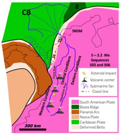
Figure 25 Paleogeographic sketch of the NWCSA and the Caribbean for the Pliocene to Early Pleistocene (accumulation time of sequences S03 to S06). Note the direct exit of the Magdalena River to the Caribbean, about 300 km NE of the sedimentary exit interpreted for sequence S02 and the change in the course of the Cauca River towards the NE. This change may have occurred at 3.5 Ma as inferred from the change in position of the depocenter between the isochore maps of S03 and S04 sequences (Figs. 18 and 19), during which time western Colombia is impacted by an asteroid [116]. Position of the Panama Arch according to GPS restorations [56].
The maximum sedimentation rate calculated in this study for the CB-SCDB-MSF area ranged between 2.36 and 2.21 Ma, period in which the S06 sequence accumulated, reaching 803 MTons/year (Table 1), six times greater than the current sedimentary rate of the MCRB (Figure 15). Such a drastic increase in sedimentation rates raises questions about the impact of time resolution on the estimation of accumulated volumes. Comparatively, it appears that with short time of accumulation, sedimentary rates tend to increase, giving rise to questions related to the continuity of the stratigraphic record and the continuity of sedimentary processes. In this scenario, it is likely that the sedimentation rate of S06 is not as high and that it may eventually be similar or slightly higher than the rate reported in the S05 sequence.
The wells drilled in the SCDB show slumps in this sequence (Figure 7), which coincide with a zone of MTC, with regional extension (Figures 5 and 6). This MTC seems to correspond with the Cartagena event [114], with a length of less than 90 km, and a width of more than 100 km. During the time of accumulation of the S06 sequence, the global eustatic sea level curve suggests a great relative sea fall (Figure 15), while the relationship between sedimentation rate and river drainage area, imply a topographic scenario much higher than that of high mountains (Figure 23). The influence of the Cartagena MTC on the increase of the sedimentation rate of the S06 sequence is probably not significant, as it is immersed in the same sedimentary sequence, so the total volume of sediments calculated includes the sediments removed by the MTC.
It is likely that during this time, the regional exhumation of the Northern Andes will increase, given the low angle subduction of the Nazca Plate under South America [89]. Additionally, the volcanic activity of phase 3 seems to be at its maximum development (Figure 16), changing from the southern Cauca Basin and central-northern Central Cordillera to the current Ruiz and Galeras volcanic centers, as well as the beginning of volcanic activity in the Eastern Cordillera [103]. The isochore map shows that a large part of the sediments in this sequence were concentrated in an intermediate zone between Barranquilla and Cartagena, exceeding 1,000 m in thickness, and forming the shape of a fan apex perpendicular to the South American continental margin (Figure 20), associated with an important increase in the sediment discharge from the MCRB, established in the region 0.5 Ma before. At the same time, sediments transported by the Atrato River to the southwest of the MSF are accumulated south of the Sinu mountain range, where they are gradually enveloped in the deformation in the Southern part of the Atrato basin, thus increasing the sedimentary rate in the CB (Figure 20). Sediments of this sequence drilled in the Kogui Rise, suggest that the source area of sediments at this time was located in the NWCSA, more than 500 km away, resulting from the advance of the MSF over the CB [45].
It is common to presume that, in the periods of major relative sea level fall, significant events of MTC become evident, especially in their initial state [95], [120], as a result of the instability of platform and slope areas [121]. However, it has been observed that MTC's can occur at any time during the evolution of the margin [122], and in the SCDB area, the origin of MTC's has been linked mainly to the structural evolution of the anticlines during the Plio-Pleistocene [40], [59], [76]. Considering the high sedimentation rates estimated during the accumulation of sequence S06, added to the major global sea level fall at this time, as well as the important volcanic activity recorded in the Central Cordillera, it may be considered that, the formation of the Cartagena MTC was governed not only by the structural evolution of the margin. Furthermore, the large extension covering the sediments of this sequence in the CB (more than 500 km in length), in such a reduced interval (150,000 years), leads to presume that the MTC's played an important role in the distribution of sediments in the area.
After the great event of sedimentary discharge of the NWCSA in the CB - SCDB - MSF, the S07 sequence accumulated between 2.21 to 1.69 Ma, at a rate of 165 MTons/year (Table 1), very similar to the rates registered during the accumulation of sequences S03 and S04. During this time, a minor global sea level rise event is recorded, as well as some volcanic events in the south and center of the Central Cordillera (Figures 8, 9 and 26). The isochore map of the sequence suggests that much of the sedimentation was concentrated on the continental margin, between Barranquilla and Cartagena, exceeding 1,000 m in thickness, at the apex of the MSF (Figure 21). To the northeast of the MSF, previous work interprets a giant MTC called Santa Marta, with a radius greater than 200 km, formed from the Pliocene to the recent one [114]. Thanks to the chronostratigraphic correlation made during this work, it is possible to consider that the Santa Marta MTC is part of the S07 sequence, specifying its age of formation between 2.21 and 1.69 Ma. The influence of the Santa Marta MTC on the increase of the sedimentation rate of the S07 sequence is considered minimal, as it is immersed in the same sedimentary sequence, so the total volume of sediments calculated includes the sediments removed by the MTC. Thicknesses less than 500 m along the southwestern border of the CB suggest that the sedimentary input from the Atrato River and the southern part of the MSF were not retained in the piggy-back basins formed in to the SCDB. The relationship between the sedimentation rate and the drainage basin area suggests a moderate topographic relief. During the sedimentation of sequence S07, in the Cauca - Patia Basin, sediments of the Zarzal Fm. were accumulated in lacustrine environments, with thicknesses greater than the subsidence rate, suggesting sediment retention, by local uplifts in the course of the Cauca River or by the advance of fans related to the Quindio Glacis [115]. Sediment retention along the course of the Cauca River may have decreased sedimentary inputs from source areas along the Western and Central cordilleras, leaving the total sedimentary load of the NWCSA towards the MSF area in the Magdalena River basin. The increase in the deformation along the SCDB could produce large MTC during this time, such as the Santa Marta MTC.
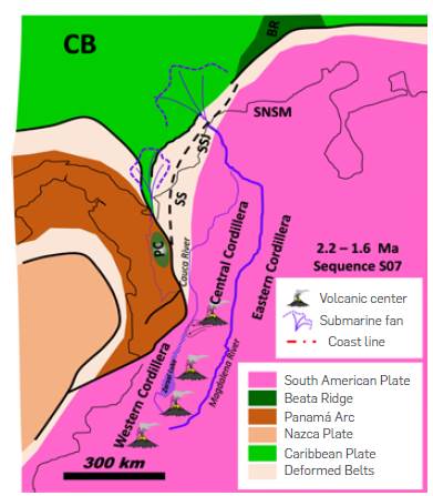
Figure 26 Paleogeographic sketch of the NWCSA and the Caribbean for the Early to Middle Pleistocene (accumulation time of sequence S07). Note the blockage of the Cauca River by the collision of the Panama Arch (Zarzal Lake), exhuming the Paramillo Complex (PC) and the arrival of flows from the Quindio Glacis [115], as well as the direct exit of the Magdalena River to the Caribbean, and the distribution of sediments in the CB restricted to the nearest area of the MSF. Position of the Panama Arch from GPS restorations [56].
During the last 1.6 My, sediments corresponding to the S08 sequence accumulated at a rate of 101 MTons/year, showing 43 MTons/year less than the rate measured during the recent one for the MCRB [25] and 64 MTons/year less than the sedimentation rate calculated for sequence S07 (Table 1). During this time, the largest thicknesses of the S08 sequence were concentrated in the MSF and along the SCDB (Figure 22) and some local depocenters in the northwest, at the base of the Hess Escarpment. The isochore map of the S08 sequence shows that the greatest thicknesses are located 70 km southwest of the current mouth of the Magdalena River into the Caribbean Sea, and suggest that the existing river mouth was established at the end of the accumulation of the S08 sequence. In the Cartagena area, limestones from the La Popa Formation accumulated in very shallow marine environments during the Pleistocene [123], indicating that much of the current coastal zone was submerged under the sea, facilitating the exit of the Magdalena River through the Canal del Dique area, migrating from the late Pleistocene [124], northward up to their current position (Figure 28). The change of course and the active deformation of the SCDB, during the accumulation of the S08 sequence, led to the formation of numerous MTCs [125], some of which have affected the underwater cable infrastructure in the last century [58],[59].
Figure 27 Topographical cross sections of the Western, Central and Eastern cordilleras (Location on the map on the right). Note how a large part of the Cauca River course presents a local base level of more than 0.5 km of difference with respect to the base level of the Magdalena River, decreasing to the west of Medellin to 0.35 km of difference, suggesting an unbalanced profile for the rivers that drain the Cauca River Basin.
In the MSF, detritic zircons recovered in exploratory wells at the base of sequence S08 show U/Pb ages from 0.3 to 0.6 Ma, ages that could suggest sources of sediments derived from the Ruiz and Galeras volcanic complexes, which record activity during the last 2 My (Figure 15), or even in the southern part of the Magdalena, where volcanic flows accumulated in the Paez zone less than 1 Ma ago [117]. Towards the top of the sequence at MSF, the recovered zircons show ages of 2.4 and 4 Ma, a similar range to the ages of detritic zircons recovered in the San Jacinto mountain range, in formations accumulated during the Plio-Pleistocene (Figure 10), suggesting that the source areas for the onshore and offshore sequences were similar during this time, probably from volcanic sources formed during phase 3 of volcanism in the NWCSA (Figure 15).
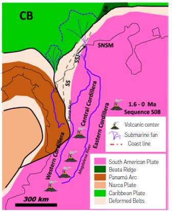
Figure 28 Paleogeographic scheme of the NWCSA and the Caribbean for the Middle Pleistocene to Holocene (accumulation time of sequence S08). Note the distribution of current volcanism, including the Paipa area in the Eastern Cordillera, as well as the direct outlet of the Magdalena River to the Caribbean, about 70 km SW of its current outlet, and the distribution of sediments in the CB restricted to the nearest area of the MSF. Position of the Panama Arc from GPS restorations [56].
Comparatively, it is to be noted that the sedimentary rate calculated for the S08 sequence decreases with respect to the previous sequences, while globally they tend to increase, except in the continental margins of the North Sea, Norway and Angola [11]. It is suggested that in the margins of the North Sea and Norway, the sedimentation rates decrease during the last 5 My given the exposure of crystalline rocks resistant to erosion, but it is still not clear what was the process that controlled the decrease in sedimentation rates in the margin of Angola [11]. In the NWCSA, the decrease in sedimentary rates occurs at times when there is an important incision along the Magdalena Valley, by sectors over 200 m [117] and the capture of drainage from the Sogamoso, Negro and Bogotá rivers [127]. However, the Cauca River Valley does not show these degrees of incision and capture of drains, showing an average difference of 500 m in its base level as compared with the Magdalena (Figure 27). Additionally, terraces with sediments accumulated in lake environments are reported on the western bank of the Cauca River, which accumulated during the Holocene to the west of Medellin [127] and to the south, in an interrupted manner during the Plio-Pleistocene [115]. The spatial and temporary discontinuous lake record along the Cauca River Valley, as well as its high base level compared to the Magdalena River Valley, suggest that the sediments of the Cauca - Patía Basin have been periodically retained by closures in the Cauca River course. Consequently, the total sedimentary rate of the MCRB decreases during the accumulation of the S08 sequence, despite the regional exhumation of the mountain ranges in the NWCSA and the dynamic processes of drainage capture in the Eastern Cordillera.
It has been considered conventionally that the SCDB is blocked by the MSF, because of high sedimentation rates recorded in this area [38]. Nonetheless, the evolution of drainage proposed in this analysis in the NWCSA suggests that, the Cauca River supplied sediments directly to the CB area between 18 and 3.5 Ma, while the Magdalena River has only contributed with sediments during the last 3.5 Ma. Considering the displacement rates between the South American and Caribbean plates of 2 cm/year [56], the total displacement in 18 My is 360 km, while for 3.5 My it is only 70 km (less than a fifth of the total displacement). This relationship of total displacement between the Caribbean and South American plates as a function of the time of arrival of sediments to the CB, allows us to suggest that the MSF area only represents one fifth of the deformation developed in the SCDB, creating the apparent structural blockage towards the northeast of this belt.
CONCLUSIONS
The seismic stratigraphic analysis integrated with the micropaleontological and geochronological analyses suggests 8 seismic sequences (S01 to S08), accumulated during the last 17.9 My in the area comprised by the CB, the SCDB and the MSF, showing coherence with global 3rd and 4th order-eustatic sea level changes of 3rd and 4th order. The thickness maps constructed for the eight sequences in the area of the CB, the SCDB and the MSF, enabled us to estimate that a total of 2.06x10¹⁵ Tons was accumulated, equivalent to 761,111 km3 during the last 17.9 My. Considering that the total volume accumulated for sedimentary sequences during this time in the Cauca - Patia and Magdalena basins represents 3.4% of the total volume of sediments accumulated in the area comprised by the NWCSA, CB, SCDB and MSF, it can be considered that the variations of the accumulation rates in the marine domain reflect processes occurred in the continental domain.
Isochore maps indicate that, from 19.9 to 5.01 Ma (time of accumulation of the S01 and S02 sequences), a rift and graben system with general east-west direction present in the CB, were covered predominantly by sediments coming from the intermountain basin formed between the Central and Western cordilleras (with a similar topography to the present one), thanks to the direct discharge of the Cauca River into the Caribbean Sea. During this time, sedimentation rates changed between 134 MTon/year and 55 MTons/year, despite the record of two volcanic phases to the south and north of the Cauca - Patia Basin, and the generalized exhumation process of the Eastern Cordillera, suggesting that much of the MCRB does not respond in a synchronous manner to topographic or climatic changes in the NWCSA. Furthermore, the relative sea level rise and the action of regional faults that dislocated the Magdalena Valley and Cauca-Patia basins, buffered sedimentation rates towards the Caribbean maritime domain.
From 5.01 to 2.7 Ma (accumulation of S03 to S05 sequences), the accumulation rates show a significant increase from 155 MTons/ year to 295 MTons/year, consistent with the change of the Cauca River course to the Magdalena River, a progressive increase in the topographic relief of the mountain ranges in the NWCSA, and the closure of volcanic phase 3 that extended along the western flank of the Central Cordillera. Along the Cauca- Patia Basin, closures and openings of the Cauca River channel as well as the impact of an asteroid, conditioned cycles of retention and contribution of sediments from the Cauca River to the Caribbean and, finally, to the Magdalena River. The diversity of processes occurred during this time interval reflect the progressive impact of Panama Arch's collision with the NWCSA and the advance of flat subduction beneath the South American Plate, as well as the beginning of glacial activity in the Eastern Cordillera.
Between 2.36 and 2.21 Ma (time during which the S06 Sequence accumulated), the maximum sedimentation rate (803 MTons/year) is recorded in the study area, a period in which there is a strong global seal level fall, an increase in exhumation in the Northern Andes, and maximum development of phase 3 of volcanism. Under such conditions, the MSF is shot on the CB in a radius of over 500 km, accompanied by regional MTC's, which took off from the northern part of the SCDB. Lastly, during the last 2.21 My, the sedimentary rates have decreased (from 165 MTons/year to 101 Mtons/year), as a consequence of periodic retention of sediments along the Cauca-Patia Basin, caused by the collision of the Panama Arch against the south of the SCDB and the northwest of the Central Mountain range.
The relationship of total displacement between the Caribbean and South American plates as a function of the time of arrival of sediments to the CB proposed in this paper, implies that the MSF area only represents one fifth of the deformation developed in the SCDB, generating the apparent structural obstruction towards the northeast of this belt.

